
Our high yesterday in Otsego was 54° with mostly sunny skies. High temperatures in the 40s and 50s will be common through Thursday. It will be mostly dry except for sprinkles in Central Michigan today and a chance of rain south of I96 on Thursday. More typical February temperatures return Friday into Saturday along with a slight chance of light snow showers.
NWS Forecast
Weather History
1986: Lake Michigan water levels are near record highs. Coastal flooding and erosion are a concern during winter storms along the shore.
On February 21, 2018, a 3-day period of heavy rain came to a close. Total rainfall from the period ranged from 1 to 3 inches with a peak measurement of 3.36″ in Livingston County. Combined with melting snowpack, this caused the Clinton River near Mount Clemens to reach moderate flood stage while the Tittabawassee at Midland fell just short of reaching major flood.
Also on February 21, 2014, the same storm that brought a round of thundersnow the day before moved off to the northeast. As this occurred, widespread wind gusts of 40 to 50 mph spread into Southeast Michigan with gusts up to 56 mph at Detroit Metro Airport and in Saginaw.
Also on February 21, 1930, the temperature rose to a record high of 63 in Detroit. This day was one of a three-day record-high streak from the 20th with 61 degrees to the 22nd with 65 degrees. Saginaw also experienced this three-day streak with temperatures of 62 degrees on the 20th, 64 degrees on the 21st, and 67 degrees on the 22nd.
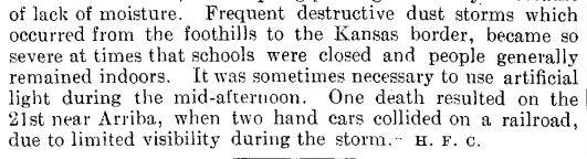
1935: Frequent dust storms occurred in eastern Colorado during the month, forcing schools to close and people to stay indoors. A fatality happened on this date when two section cars collided on the railroad near Arriba Colorado due to poor visibility.

1971: A tornado outbreak struck portions of the Lower Mississippi River Valley and the Southeastern United States on February 21–22nd. The two-day tornado outbreak produced at least 19 tornadoes, probably several more, primarily brief events in rural areas, and killed 123 people across three states. The tornadoes “virtually leveled” entire communities in the state of Mississippi.

In Mississippi, the storms killed 107 people, injured 1,060, and hospitalized 454 others. On March 23, 1971, the Mississippi Civil Defense Council estimated 17 million dollars in property damages. In addition, 131,308 individuals received disaster service from the Salvation Army in nine areas. As of 1971, in terms of fatalities, the outbreak produced the fourth-highest number of deaths in Mississippi from tornadoes on one day. The top five tornado events include 317 deaths on May 7, 1840, in Natchez, 216 deaths on April 5, 1936, in Tupelo, 160 deaths on April 20, 1920, in the northeast and east-central Mississippi, 107 deaths from the Mississippi Delta outbreak on February 21, 1971, and 100 deaths on April 24, 1908, in Lamar to Wayne Counties.
Aerial surveys showed that most storm reports from various sources fit into three main tracks. The surveys also found three principal tornadoes contributed to over 300 miles of tornado track, varying in width from 1/4 miles to more than 1/2 mile. One track extended 159 miles as a continuous storm, beginning southwest of Cary, passing west of Belzoni, Greenwood, and Oxford, with the tornado lifting near Abbeville. After passing over Abbeville, the tornado redeveloped to the southwest of Bethlehem in Marshall County and continued northeast to Selmer, Tennessee. Another tornado first developed near Delhi, Louisiana, and continued 102 miles to near Schlater, Mississippi. The tornado struck the towns of Delta City, Inverness, and Moorhead. A third major storm began south-southwest of Bovina, passed through Little Yazoo, and ended near Lexington for a path length of 69 miles. Although much shorter, about eight miles, a fourth track extended from north of Drew to near Rome.
The three significant tornadoes traveled at speeds of 50 to 60 mph. The speed was determined from a selected set of more reliable checks at various locations. All the death occurred along these three tornado tracks. Between 11:56 am and 9:00 pm, the Jackson, Mississippi River radar showed hook echoes in 28 observations. Some of the hooks were as far away as 90 miles. At one time, as many as four hook echoes were observed on the radar.
The Mississippi State Department of Education indicates more than $1.2 million in damages to schools and their contents. At nine canteen sites established by the Salvation Army, there were 94,337 food servings through March 8, 1971. The Mississippi Power and Light Company reported its most significant wind damage in company history. A total of 68 115,000 volt transmission line structures were downed at 14 different locations, with damage that exceeded $290,000, with about 50 percent in Humphrey County and 40 percent in Sharkey County. The South Central Bell Telephone Company’s losses exceeded $300,000. They lost 4,600 telephones, 3,250 long-distance circuits were affected, and 205 telephone poles were destroyed. Ten exchanges were on emergency power. The American Telephone and Telegraph Long Lines department lost its microwave tower adjacent to Bentonia, and 1,800 circuits were affected.
At Inverness, at about 4:40 pm, a powerful tornado destroyed 90 percent of the small business district, and 75 percent of the homes were damaged. The storm caused 21 fatalities. Officials noted 153 homes destroyed, 52 had major damage, and 90 received minor damage. The businesses destroyed or damaged in Inverness totaled 61, and farm buildings destroyed was 30. In and near Inverness reports that some people sought shelter from the oncoming tornado by getting in bathtubs, curling up in mattresses, and crawling into haystacks. The tornado was reported to have struck for about 2 minutes, and all electrical powerlines, telephone, and water lines were destroyed. A man who resides on the north edge of Inverness told the newspaper, “At first, just before the storm, it was very quiet and calm…Then I heard (the tornado) for about 3 minutes before I saw it. It was a big funnel cloud…” The Indianola newspaper noted that along the path of the tornado, there was “lots of debris, that is visible on cropland, especially warped tin and larger pieces of lumber.”

A tornado struck south-southwest of Bovina at about 5:06 pm and, during a 3-mile track, killed a man and his wife. A man to the south of Bovina “went out on the porch and looked down the road and saw the storm coming.: It was a “half mile down the road.” There was “an unnatural calm” just ahead of the storm. “We could hear it coming through and could see lumber and debris flying in the air. It was yellow in the center.”
A tornado struck Holmes County at about 6:10 pm. The Lexington newspaper noted, “A tornado touch down in the southwest corner of Holmes County in the Bronzville community. The damage in the Brozville area was not extremely heavy but caused extensive damage to barns, chicken houses, sheds, and a few homes.” The tornado apparently lifted afterward and rose above Lexington as the storm continued to the northeast.
Another tornado crossed Yalobusha County from 5:53 pm to 6:23 pm. The cooperative weather observer at Water Valley wrote, “The damaged area, Cascilla (Tallahatchie County) to Tillatoba (Yalobusha County) was about 200 yards wide, but as it moved across Yalobusha County, it began to narrow and tip along, just bumping here and there.” As the tornado crossed Highway 315, four miles northeast at the north end of the Yacona River bridge, it was no more than 150 feet wide. The timbered Yacona River bottom areas had roofing material, wallpaper, and insulation from least as far away as Tillatoba. The winds carried many items for some distances. A report was received that checks and/or portions of checks from the Bank of Anguilla, Sharkey County, were found in Panola County, around 140 miles away.

2013: An astonishing 515 cm (202.8″ or almost 17′) level of snow depth was measured at Sukayu Onsen, Aomori on Honshu Island in Japan, on February 21, 2013, the deepest snow measured at an official weather site in Japan records. (Last Updated in 2020). Click HERE for more information from Weather Underground.
Forecast Discussion
- Mild Today and Thursday with limited chances for rain

The warmest low-level air of the week, associated with a
southern stream ridge, will advect into Lower Michigan today.
Temperatures in the 50s are good bet over much of the area
especially south of Holland-Alma. Virga is likely and possibly
sprinkles or passing light rain showers in Central Michigan
during the day. Subtle height falls and PVA associated with
northern stream troughing around 500 mb should provide lift for
moisture/clouds streaming through at 10,000 feet, while there
remains a fair amount of dry air beneath those clouds.

Low pressure tracking through the Ohio river valley region on
Thursday is likely to keep any meaningful rain amounts contained
to far southern Michigan and areas south of there. The
constituency of global ensemble members -- and now also the
members of the HREF -- which produce 0.2 to 0.5 inch rainfall
for the I-94 area remains a minority. Still a little too close
to rule out completely, but unlikely to see a good soaking.
PoPs are decreased to chance for I-94 and closer to slight
chance for I-96.

- Low chances for snow showers Friday and Friday night

Upper Low centered over James Bay with cyclonic flow and trough
axis swinging through will bring a chance of lake-enhanced snow
showers or flurries from Friday morning into Saturday morning.
A limiting factor is very shallow moisture with model soundings
showing the inversion heights below 5 kft and dry profiles. We
have added slight chance POPs for this period. Northwest to
north flow would limit activity to near the coast.

- Medium Confidence in rain moving in by Tuesday

Surface high moves east over the weekend with quickly
moderating temperatures in quasi-zonal flow regime, then we wait
for moisture return early next week along with warm
advection/isentropic lift bringing increasing chances for rain
breaking out by Tuesday. The NBM likely POPs for Tuesday
afternoon were not changed, although there are still some model
differences with the details of a shortwave trough minoring out
across Lower Michigan that could affect the placement of the
higher POPs in future forecast updates.
Hot summer = Hell on Earth, especially if the dew points are high! Absolutely horrible.
60’s all over the state! Keep the warmth coming!
61 here. Clouds have moved in but still getting some peeks of sunshine.
Record high temps next week?
https://www.mlive.com/weather/2024/02/record-heat-coming-again-next-week-for-michigan-60s-look-likely.html
Is it too early to start thinking about summer? I think not:
https://www.mlive.com/weather/2024/02/summer-forecast-el-nino-switching-to-la-nina-points-toward-a-warm-summer.html
Oh great? That’s all we need is a hot summer! Pathetic and I hope that outlook is dead wrong! Give me cool summer, all day every day!
Warm Winter+Hot Summer=Heaven on Earth!!
60 at my location currently. I was outside and was thinking I could easily just wear a short sleeve and be fine. Heck half tempted to break out my shorts
Fun fact one year ago we had Winter Storm Warnings and Ice Storm Warnings being issued in our viewing area. What a difference a year makes.
It does! Just hit 61 here Kyle. Temps over performing today!
Yep I have rose 1 more degree now to 61
The day started off dark and gray. The sun is now out and the temp has jumped to 50 already. I see that 62 is in the forecast for next week.
Anyone see any robins yet? I heard one chirping yesterday morning but never actually saw it. Whether or not it’s one that stayed all winter or migrated back I’m not sure but I’m sure we will start seeing more of them.
I have seen a ton of them. Even a few weeks ago I saw them.
I’ve seen several. Then again, not all robins migrate. Some stay here for the winter.
Interesting. I guess I’ll have to keep my eye out for them. I haven’t actually seen one yet. Hopefully soon.
I saw a mosquito two weeks ago during one of the 60-degree days.
Noooo!!!!
Hey Kyle, I heard them too, but I have not seen them yet.
The 1st 20 days of February are now in the history books and at Grand Rapids the mean is 33.7 that is a departure of +7.6 at this point this February is the 4th warmest of record for GR. The high for the month so far is 59 and the low so far is 12 there has been 0.53” of participation and just 5.5” of snowfall. Several of the next 9 days look to be well above average so we shall see how this February ends up. The current warmer years are 34.7 in 2017, 34.1 in 1998 and 34.0… Read more »
And essentially all of that snow fell during one calendar day
The official H/L yesterday was 50/21 there was no rain/snowfall. The sun was out 85% of the possible time. The highest wind speed was 20 MPH out of the S. It was a nice day to be outside and the maple trees have their sap running. For today the average H/L is 35/21 the record high of 66 was set in 1930 and the record low of -8 was set in 1968. The wettest was in 1997 with 2.96” of that 3.0” fell as snow. The most snowfall is 6.0” in 1898. The most on the ground was 20” in… Read more »
One of the largest maple syrup farms in Michigan started collecting sap the earliest date in 45 years. They started in early feb. I have 25 taps out right now, and I think I missed the best flow, the night time temps look very warm.
https://www.mlive.com/weather/2024/02/maple-syrup-season-off-to-early-start-with-michigans-record-warmth.html?outputType=amp
20,000 gallons of sap per day? That’s a bunch!