We are starting Tuesday with temperatures in the teens and 20s but will warm up close to 50 with plenty of sunshine. This is about 10 to 15 degrees warmer than the average high for this time of year. Tomorrow and Thursday will be the same, with a chance of rain Wednesday night into Thursday. Temperatures will cool closer to normal into the weekend.
NWS Forecast
Weather History
1898: A snowstorm dumps over a foot of snow on parts of Lower Michigan on the 20th to the 21st. Grand Rapids has 11 inches from this storm and almost 30 inches for the month of February.
1951: Ice jam flooding along the Grand River in Portland damages several buildings and forces the evacuation of some neighborhoods near the river.
2015: This is the coldest morning of one of the coldest months on record at Grand Rapids as the temperature falls to a record-cold 13 degrees below zero. The monthly mean temperature of 13.3 degrees makes this the coldest February on record and the fourth coldest month ever.
On February 20, 2015, another calm and clear night during this frigid month allowed the temperature to fall to -25 in Flint, tying January 18, 1976, for the coldest temperature ever recorded there. The NWS office in White Lake also set a new all-time low of -25 degrees, albeit with a much shorter climate record. The temperature in Saginaw and Detroit reached -15 and -12 degrees respectively, also both records for the date. As temperatures struggled to rebound from cold early-morning lows, the average temperature for the day in Flint and Saginaw only reached -5 and -1, both records for the date.
Also on February 20, 2014, A brief burst of heavy snow led to minor accumulations of 1 to 2 inches across the metro area. There were numerous reports of thunder accompanying the snowfall.
February 20, 2011, a winter storm impacted southeast Michigan, with 5 to 10 inches of snow falling across the majority of the area. Snow turned to ice near the Ohio border, where a major ice storm occurred. Downed trees and powerlines occurred over Lenawee and Monroe counties due to ice accumulations from half an inch to one inch. Power outages lasted 4 to 5 days.
Much of Southeast Michigan was hit with a snowstorm with generally 6 to 9 inches of snow. The Tri-Cities area was the hardest hit with many locations reporting 12 inches of snow.
1912: A strong area of low pressure produced snow in Amarillo and high winds to Austin, Texas. In the warm sector of the low, severe storms developed and produced an estimated F3 tornado in Shreveport, Louisiana. The tornado killed nine people and injured 50 others. The tornado passed near Centenary College, where windows were damaged, and the grandstand at the ballpark was partially damaged. In addition, significant damage occurred in the Freewater section, where an estimated 75 to 100 houses were demolished. Click HERE for more information on the Austin, Texas wind storm from the Monthly Weather Review.
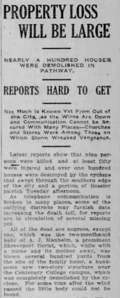 February 20th, 1912: Shreveport, LA Tornado February 21st 1912, Wed The Shreveport Journal (Shreveport, Louisiana) Newspapers.com
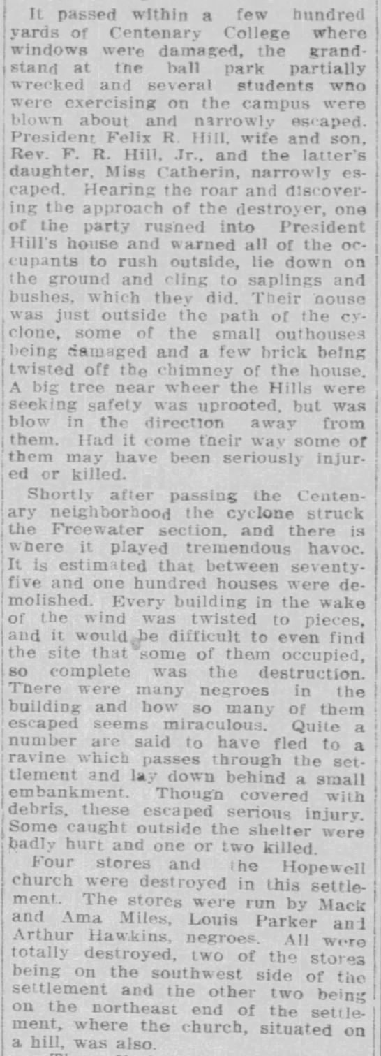
1912: During the 20th and 21st, a severe snowstorm attended by high winds lasting from 34 to 30 hours swept over Illinois, Indiana, and Ohio. The amount of snow that fell in this storm was not only large, but it drifted severely. In many places, snowbanks 5 feet and higher were formed, railroad cuts were filled, highways in many places were impassable, electric service wires of all kinds were temporarily put out of commission, all trade and traffic generally demoralized. This snowstorm was part of a general disturbance that developed over the southwest on the 20th and moved northeastward over the Central and Eastern States, increasing in strength during the 21st and 22nd, and which proved to be one of the most severe and most extensive general disturbances that have passed over this section of the country for several years past. Besides the heavy snow in the northern part of the storm, heavy rains, gales, and destructive thunderstorms attended over most of the southern and eastern portions. Wind velocities of 50 to 75 miles per hour were reported at many places during the passage of this storm. Some wind blew steadily at high velocities for several hours. Click HERE for more information from the Monthly Weather Review.
1995: The temperature at the Civic Center in Los Angeles, California, soared to 95 degrees, the highest ever recorded at the location during February.
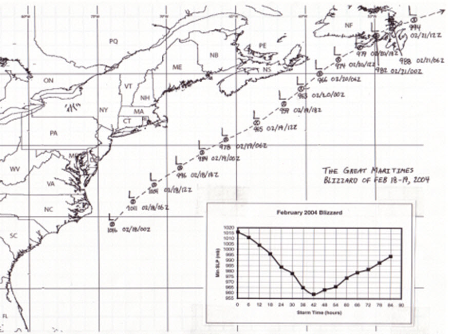
2004: A nor’easter brought heavy snow and strong winds to Nova Scotia and Prince Edwards Island from February 17th through 20th, 2004. The Maritimers called this storm White Juan, a hurricane disguised as a blizzard. Halifax, Yarmouth, and Charlottetown broke all-time 24-hour snowfall records, receiving about 3 feet of snow. The 34.8 inches of snow on February 19th nearly doubled its previous record for a single day for Halifax. The map below is from “The Great Maritimes Blizzard of February 18-19, 2004” by Chris Fogarty from the Atlantic Storm Prediction Centre, Dartmouth, Nova Scotia.
Forecast Discussion
- Mostly Sunny and Mild Today

High temperatures will climb to about 15 degrees warmer than
normal today with a gentle breeze from the south and plenty of
sunshine. Bumped up the forecast high temperature today 1 to 2
degrees above the NBM, as highs exceeded the NBM yesterday and
much of the day will have full sunshine until patches of
mid/high-level clouds move through later in the afternoon.

- Warm Wednesday With Some Clouds and Chance Sprinkles

Warmer temperatures will be advected in on Wednesday along with
some patchy mid and high altitude clouds. Most models are
showing clouds around 10,000 feet poised to precipitate during
part of the day, but it will likely only result in virga or
sprinkles given fairly dry air beneath. Dew points climbing
above 32 degrees along with a breeze on Wednesday should inflict
extra hostility to whatever snowpack remains.

- Chance of Rain Wednesday Night to Thursday, Amounts Not Settled

A southern stream shortwave trough and associated surface low
is likely to track over the Ohio valley region Thursday. Will
maintain chance for rain showers over the southern third of the
lower peninsula Wednesday night and Thursday. Our precip amount
forecast for Kalamazoo-Jackson is up to 0.10 inch, however,
there remains quite a wide range of possibilities in the ECMWF
and GFS ensembles, depending on where the low-pressure system
tracks. There are still about 15-20 percent of members that are
dry and also 15-20 percent of members that produce 0.5 to 1 inch
of rain. So confidence is not high at this time. The wave
responsible for this is currently west of California.

- Briefly Colder With Light Snow Possible Late Friday to Saturday

A northern stream trough with polar air is likely to dig into
Ontario and the Great Lakes Friday to Saturday. There remain
subtle differences in the amplitude of the trough and the
southward extent of coldest temperatures among the ensembles,
but ultimately this will likely be a quick visit of air that is
near or somewhat colder than normal. Light snow showers are
possible with the cold front late Friday and perhaps some lake-
effect into Saturday. Any snow should be rather limited due to
dry air and a tendency for low-level ridging under the upper-
level trough.

- Another Warmup Early Next Week

Still a reasonably strong signal in the ensembles for much
above normal temperatures returning from Sunday to Tuesday, as
the longwave pattern supports troughing in the western CONUS and
ridging in the central-east. There has been at least some
signal for this pattern for about a week now. Also there is a
better-than-average signal for precipitation at some point
between Monday night and Wednesday, though ensembles do diverge
somewhat in the evolution of this pattern. A fair number of
solutions develop a low pressure system in the Midwest and also
have enough instability for thunderstorms.
50 degrees and nothing but blue sky here. 18 days in February above average and just two days below average. This will end up being one of the warmest Februarys on record.
“This weekend may turn out to be the coldest weekend we’ll see until next winter.”
Even Bill Steffen is saying winter is pretty much dead already. I love it!
When Bill throws in the towel on winter, you know it’s dead!
After all the talk of a cold and snowy February, the month looks like it will end up being super mild and below average snowfall.
Oh you mean this wasn’t true??
Rocky (Rockford)
All long range models show a major cool down and about 6 more weeks of winter weather! WOW! Winter Weather Warning continues! Incredible! Get ready to rock!
February 7, 2024 10:59 am
Oh and the pattern change that lasted for a few days!
Rocky (Rockford)
We sure have seen some horrible winter weather lately! Temps in the upper 30’s and no snow! Now for the good news – the pattern will be changing to colder and snowier around the middle of this month! The AO will be tanking and that means colder temps! GREAT NEWS – we still have 7 plus weeks of winter left! Bring it on!!
February 3, 2024 9:36 am
Even WOOD and Bill’s Blog kept mentioning a cold and snowy back half of February! Whoops!
Too funny! Just more Kirkwood wishcasting as usual!
This looks more like a late March (even early April) type of pattern. I have no complaints… maybe I can get some tennis or golfing in
The official H/L yesterday at Grand Rapids was 42/12 there was no rain/snowfall and there was 89% of possible sunshine. For today the average H/L is now up to 35/20 the record high of 63 was set in 2018 that day also had the record rainfall of 2.53” the record low of -13 was set in 1966 and 2015. The record snowfall of 7.0” fell in 2011 the most on the ground was 21” in 1936. Last year the H/L was 41/26.
Slim
There was a nice red sunset last night. It was once again a rather cold night with a low of 19 here in MBY. With clear skis I now have 20.
Slim
Winter is dying. I will call this the 3 week winter. I love it!
What?!?!? I thought we were going to get hammered and pummeled by endless snowstorms and highs in the teens from November through April??? I was told to prepare in October for it.