Today we remember and honor those who have passed in service to their country. Every year I write about my father in law who passed away 12 years ago, he served his country in the Army during WWII as a Staff Sergeant in the 126th Infantry and 32nd Red Arrow Division and was involved in campaigns in Papua, New Guinea, the Southern Philippines and Owen Stanley Mountain Conflict. Merle was wounded at Leyte Island in the Philippines on November 28, 1944, and was awarded the Purple Heart, Bronze Star, and many other honors of distinction. He was a member of the Ghost Mountain boys.
He liked talking about his time in the service to his country though he never talked about the horrors of battles he experienced. A book was written by James Campbell who served in the same division which is for sale on Amazon. It talks of the horrible battle conditions they had to deal with. Most WW2 vets don’t talk about it, they were mostly tough farm boys who went to war when Japan woke the sleeping giant that is our country. Take time to remember those who fought and died for their country whom we owe our freedoms.
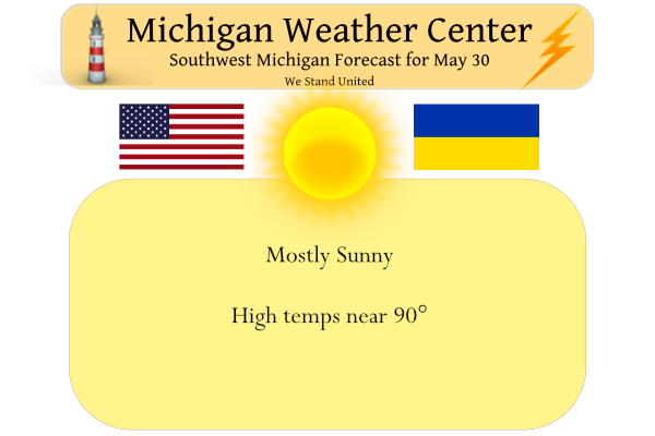
We expect a warm day today with highs near 90°. Yesterday our high was 82° and the morning low was 54.5°. We have 64° at 6 a.m.
Storms will stay to our west today:
[columns] [span6]

Numerous severe thunderstorms are forecast across parts of the Northern Plains and Upper Mississippi Valley southward into the central Plains today into tonight. Large to giant hail, 60-80 mph gusts, and tornadoes are probable, including the possibility for a couple of intense long-track tornadoes.
[/span6][span6]
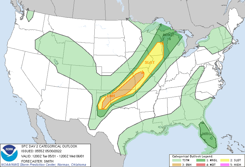
Widely scattered to scattered severe thunderstorms are likely from Wisconsin southwestward into the lower Missouri Valley and into parts of the southern High Plains mainly Tuesday afternoon and Tuesday night. There is a risk for large to very large hail, severe gusts 60-80 mph, and a couple of tornadoes.
[/span6][/columns]
Forecast Discussion
--Continued warm today and Tue--

Sustained southerly low-level flow will keep warm air in place today
and into Tue. An upper ridge over eastern North America will
continue to amplify today--a downstream response to the digging
western CONUS trough on Sun. Highs today and Tue are expected to
climb into the mid 80s to near 90F away from Lake Michigan, with
breezy conditions during the daytime periods.

--Showers/thunderstorms Tue evening; risk of severe storms--

A surface low over western KS this morning will propagate
northeastward today and tonight, reaching the vicinity of northern
MN by 12z Tue, then into central ON by 00z Wed. The trailing cold
front is expected to be positioned west of the area at 00z Wed,
likely extending from eastern Lake Superior, to near Milwaukee, to
near the Quad Cities. Aloft, guidance suggests that a 70-kt
500-mb jet streak will be situated northwest of the area at 00z
Wed--likely arcing from southern WI into the eastern U.P.--and
associated with a strong shortwave trough lifting toward the
northern Great Lakes.

By 21z Tue, warm surface temps, combined with dewpoints in the
low/mid 60s F, should yield MLCAPE of 1000-2000 J/kg across
portions of the CWA (away from the lake-modified boundary layer),
along with weakening inhibition. Lift accompanying the midlevel
trough/jet streak--perhaps aided locally by lake-breeze
convergence--may result in isolated thunderstorms prior to 00z,
mainly across the western/northern CWA. However, deterministic
CAMs and HREF suggest that convective initiation prior to 00z is
questionable. Nevertheless, if surface-based storms develop
before 00z Wed, the presence of 30+ kts of effective bulk shear
suggests that storm organization is possible, with the main risks
of damaging gusts and large hail.

Storms will likely become more numerous after 00z, aided by
convergence/lift along the cold front. These storms may pose a risk
of damaging gusts and large hail, particularly if updrafts can
remain at least partially surface based. However, a trend toward
elevated storms is expected with the onset of boundary-layer
cooling, limiting the window of the damaging-wind threat.

--Showers possible Wed into Thu--

Recent ensemble guidance (EPS and GEFS) has trended the frontal
position southward for Wed and Thu. Correspondingly, QPF exceedance
probs have shifted southward on both days, and PoPs with this
forecast package reflect this trend. Still, low PoPs (chance) are
maintained on Thu for most of the CWA, when QG forcing for ascent
ahead of a midlevel shortwave trough should foster at least
widely scattered showers.

--Dry on Fri/Sat, rain chances return for Sat night/Sun--

Guidance remains consistent in depicting surface high pressure
building into the region on Fri, maintaining pleasantly cool and
settled conditions into Sat. A shortwave disturbance approaching in
WNW flow aloft may bring rain for Sat night into Sun.
The long range CFSv2 guess continues to hint at cooler than average temperatures for much of June with a dryer start and then maybe a wet week and then a chance of a warm end. We shall see how that plays out.
https://www.cpc.ncep.noaa.gov/products/people/mchen/CFSv2FCST/weekly/
Slim
Bring it baby!
The official H/L at Grand Rapids yesterday was 81/55. There was no rain fall and there was 68% of possible sunshine. The overnight low here at my house was 66 and the official low looks to have been 67. If it stays above 66 until midnight it will be one of the warmest minimums for any May 30th. At The current time it is 67 here at my house. The average H/L for today is 75/54. The record high for today is 92 set in 1919 and the record low is 34 set in 1996 and 1965. If it makes… Read more »