
We received .14 of an inch of rain overnight which brings our total for the month to 4.70 inches. Our high for yesterday reached 81.1° and our low was 64.8° this morning.
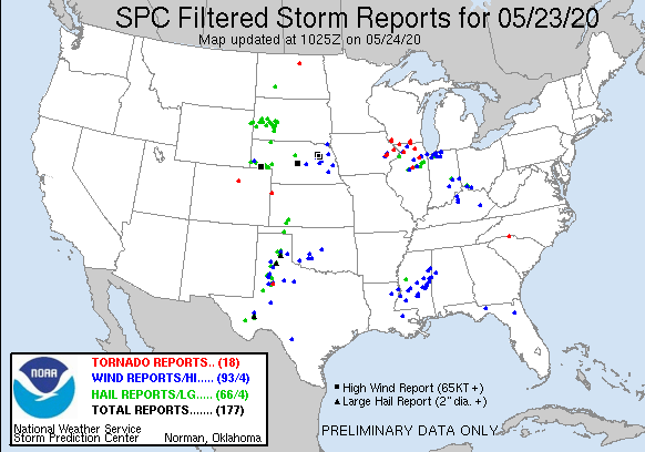
There were 18 tornado reports last night. The severe weather was knocked down by Lake Michigan giving us mainly rain.
| Time | Location | County | State | Lat | Lon | Comments | |
|---|---|---|---|---|---|---|---|
| 1743 | SUTIFF | JOHNSON | IA | 4183 | 9138 | THE LISBON FIRE CHIEF REPORTED A TORNADO ON THE GROUND SOUTH OF SUTLIFF. THERE ARE MULTIPLE REPORTS AND PHOTOS FROM THE SAME AREA. TIME ESTIMATED BASED ON RADAR. (DVN) | |
| 1803 | MECHANICSVILLE | CEDAR | IA | 4190 | 9125 | RELAYED BY CEDAR RAPIDS WARNING POINT OF TORNADO ON THE GROUND AND MOVING NORTH. TIME ESTIMATED USING RADAR. (DVN) | |
| 1856 | 2 E PANOLA | WOODFORD | IL | 4079 | 8898 | TORNADO REPORTED ON THE GROUND (ILX) | |
| 1925 | 1 NNE ANDREW | JACKSON | IA | 4217 | 9058 | A TRAINED SPOTTER REPORTED A TORNADO ON THE GROUND 1 MILE NORTH NORTHEAST OF ANDREW. (DVN) | |
| 1936 | 2 W KINGS MOUNTAIN NP | YORK | SC | 3514 | 8140 | NWS STORM SURVEY REPORTED AN EF1 TORNADO THAT BEGAN IN CHEROKEE COUNTY PASSED THROUGH KINGS MOUNTAIN NATIONAL MILITARY PARK IN YORK COUNTY. THE TORNADO CONTINUED EAST/N (GSP) | |
| 1949 | 3 SE MILLEDGEVILLE | CARROLL | IL | 4194 | 8973 | BRIEF TORNADO TOUCHDOWN SOUTHEAST OF MILLEDGEVILLE … HAS SINCE LIFTED. HAVE HAD SEVERAL REPORTS OF BRIEF TOUCHDOWNS. (DVN) | |
| 2002 | 1 NW MINOOKA | KENDALL | IL | 4146 | 8827 | TRAINED SPOTTER REPORTED A TORNADO LOOKING NORTH FROM I-80 AND RIDGE RD. BEFORE IT BECAME RAIN-WRAPPED. (LOT) | |
| 2010 | 2 S LANCASTER | GRANT | WI | 4282 | 9071 | LOCATION ESTIMATED. TORNADO HAS LIFTED. (ARX) | |
| 2035 | 4 NW LANCASTER | GRANT | WI | 4289 | 9077 | SEEN BY 4 SPOTTERS. (ARX) | |
| 2120 | WARREN | JO DAVIESS | IL | 4250 | 8999 | REPORT OF A TORNADO JUST NORTH OF WARREN BY A TRAINED SPOTTER … RELAYED FROM COUNTY 911. (DVN) | |
| 2121 | 1 NNE WARREN | JO DAVIESS | IL | 4250 | 8999 | TREE BRANCHES DOWN. (DVN) | |
| 2130 | 4 SSW DACONO | WELD | CO | 4002 | 10496 | BRIEF LANDSPOUT ON THE GROUND FOR 2 TO 3 MINUTES. (BOU) | |
| 2200 | 2 E BELOIT | ROCK | WI | 4253 | 8897 | MULTIPLE REPORTS BY STATE PATROL OF AN ONGOING TORNADO NEAR THE I-90/I-43 INTERCHANGE. (MKX) | |
| 2205 | 4 W CLINTON | ROCK | WI | 4256 | 8894 | BRIEF TOUCHDOWN 4 MILES WEST OF CLINTON. (MKX) | |
| 2215 | 9 ESE DRAW | GARZA | TX | 3299 | 10151 | (LUB) | |
| 2226 | 4 SE JANESVILLE | ROCK | WI | 4264 | 8898 | (MKX) | |
| 2312 | 5 NE GENOA | DE KALB | IL | 4214 | 8862 | 40 X 20 BARN DAMAGES WITH DEBRIS BLOWN DOWNSTREAM INTO A FIELD … POWER LINES DOWN ABOUT A MILE DOWNSTREAM … LIKELY TORNADO PATH BASED ON SPOTTER REPORTS AND RADAR. (LOT) | |
| 2352 | 2 N YORK | Benson | ND | 4834 | 9957 | PUBLIC REPORT OF A LANDSPOUT RECIEVED VIA LOCAL PSAP (FGF) | |
| 0009 | 3 W RULETON | SHERMAN | KS | 3934 | 10193 | BRIEF LANDSPOUT. (GLD) |
We remain in the general thunderstorm outlook area for the next three days. If we see any rain or storms they will be of the popup variety. Temps will become tropical in the 80s with dewpoints in the 60s. Overnight low temps will be in the mid-60s.
Whew!!! Had to fire up the AC!!! Temps in the 80’s, hot for this time of year! More like July out there!! Stay cool everyone!!
Loving all these days that feel like mid summer in May! I love long summers!
Currently, it is sunny and 75 here. Now what happened to last nights rain? The storms to the SW just did not make it here at all. Not that we need any rain at this time, but I was not expecting to receive no rain at all.
Slim
Enjoying coffee whilst overlooking the lake this morning. Wear sunscreen today. It’s going to feel Independence Day rather be than Memorial Day.
Nothing new what a cooler lake Michigan can do storm sherrrder once called by a former Bills blogger back in the day…Today’s weather perfect get outside and enjoy our freedom as being a American on this holiday weekend, sprites will be going down right as I should be with my 350 thousand race fans getting ready for the greatest spectacle in racing the INDY 500!! Cheers to you have a great day …JNDY …