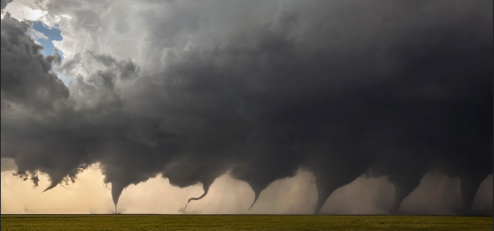
Tornadogenesis is the process by which a tornado forms (feature image). There are many types of tornadoes and these vary in methods of formation.
There are various forms and sub-forms of tornadoes. Although each tornado is unique, most kinds of tornadoes go through a life cycle of formation, maturation, and dissipation.
Mesocyclones
Classical tornadoes are supercellular tornadoes, which have a recognizable pattern of formation. The cycle begins when a strong thunderstorm develops a rotating mesocyclone a few miles up in the atmosphere. As rainfall in the storm increases, it drags with it an area of quickly descending air known as the rear flank downdraft (RFD). This downdraft accelerates as it approaches the ground, and drags the rotating mesocyclone towards the ground with it. Storm relative helicity (SRH) has been shown to play a role in tornado development and strength. SRH is horizontal vorticity that is parallel to the Inflow of the storm and is tilted upwards when it is taken up by the updraft, thus creating vertical vorticity.
Misocyclones
Waterspouts
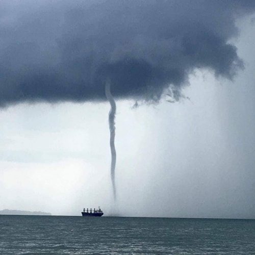
Waterspouts are defined as tornadoes over water. However, while some waterspouts are supercellular (also known as “tornadic waterspouts”), forming in a process similar to that of their land-based counterparts, most are much weaker and caused by different processes of atmospheric dynamics. They normally develop in moisture-laden environments with little vertical wind shear in areas where wind comes together (convergence), such as land breezes, lake effect bands, lines of frictional convergence from nearby landmasses, or surface troughs.
Waterspouts normally develop as their parent clouds are in the process of development. It is theorized that they spin upward as they move up the surface boundary from the horizontal shear near the surface, and then stretch upward to the cloud once the low level shear vortex aligns with a developing cumulus or thunderstorm. Their parent cloud can be as innocuous as a moderate cumulus, or as significant as a supercell.
Landspouts
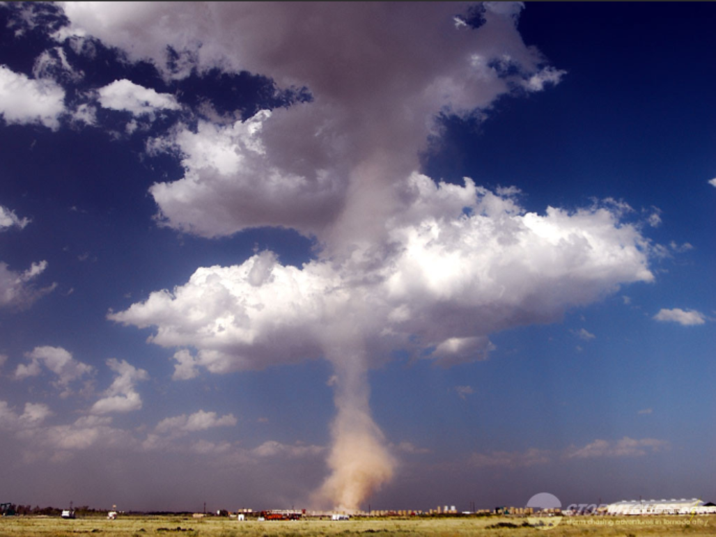
Landspouts are tornadoes that do not form from supercells and are similar in appearance and structure to fair-weather waterspouts with the exception that they form over land instead of water. They are thought to form in a manner similar to that of weaker waterspouts in that they form during the growth stage of convective clouds by the ingestion and tightening of boundary layer vorticity by the cumuliform tower’s updraft.
Mesovortices
QLCS
Tornadoes sometimes form with mesovortices within squall lines, most often in middle latitudes regions. Mesocyclonic tornadoes may also form with embedded supercells within squall lines.
Tropical cyclones
Mesovortices or mini-swirls within intense tropical cyclones, particularly within eyewalls, may lead to tornadoes. Embedded supercells may produce mesocyclonic tornadoes in the right front quadrant or particularly in certain situations with outer rainbands.
Fire whirls and pyro-tornadogenesis
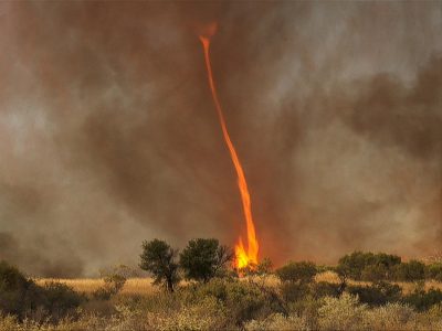
Most fire or volcanic eruption induced whirlwinds are not tornadic vortices, however, on rare occasion circulations with large wildfires, conflagrations, or ejecta do reach an ambient cloud base, and in extremely rare cases pyrocumulonimbus with tornadic mesocyclones have been observed.
Seven Day Forecast
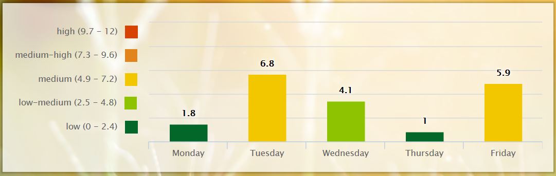
Pollen Forecast
Great post MV. Lots of info on tornadoes. As an adult I have been camping and dealt with them when the kids were all very young. I also have seen them come down and go back up. It is amazing the technology we have to forecast them. I always remember what I learned from a meteorologist (back in the 70’s) say that by the time they see it on radar to notify us it has to already hit somewhere. Is that true today?
It’s no wonder why we had flooding: ..TIME… …EVENT… …CITY LOCATION… …LAT.LON… ..DATE… ….MAG…. ..COUNTY LOCATION..ST.. …SOURCE…. ..REMARKS.. 0354 PM HEAVY RAIN 2 NE LANSING 42.73N 84.53W 06/10/2019 M3.98 INCH INGHAM MI MESONET 2 DAY RAINFALL TOTAL.
One two-day total about 8 miles north of here was 4.75″.
Wow what a cool pattern! Will June make it 6 months in a row?
Will this be the year of no summer ? Could we see more 60s into July ?? As one would say . “Stay Tuned”
It could be the year of no summer and no 90’s Who would have thought?
Beginning to think the same .. I will take 70s all day .. Wouldnt hurt my feelings if there were no 90s this year.
I agree give me 70’s and low 80’s all summer long!
Great fire weather if the wind will die down for this time of year .. Hopefully the cool weather keeps the sketo’s at Bay …INDY!!
Got my first mosquito bite of the season this past weekend.
Slim we maybe racking leaves around the end of August it’s stays this cool …INDY!
This is a cloudy and very cool June day across Michigan. While the official high today will be 67 that occurred overnight and now the temperature here at my house is a cool 59° Across Michigan the range is from 69 at Detroit to the low 50’s at several locations in northern Michigan.
Slim
54* degrees now temps are falling getting chilly outside time to build a fire lol..INDY!
2.88″ of rain overnight and this morning. Several roads flooded. I even saw a vehicle stranded in the road at the end of our neighborhood with water up to his bumper. Come to find out, it was a high schooler. Needless to say, he was late to his final exams.
Wow! I thought we had a lot with about an inch and a quarter. When it came down, it was hard and fast.
61* degrees out at thee YARDofBRICKS I’m thinking it’s October not June and I love how Slim said it no “REAL” heat anytime soon it’s been a year now since we have had any “REAL” heat around here with that thought we are about 2 and a half weeks from summer’s longest day of the year then we know after that what comes!!! Have a great Monday, MV my continue prayers for you and your family through this difficult time ..INDY!
Be fine with me if it stayed like this year around. Saturday was miserable working 14 hours in heat over 100 degrees. And it hasn’t been a year since our last heat since September into early October was still hitting 90 degrees last year. More like 9 months.
Talking summer months not Fall..Carry On! INDY!!
September is two thirds a Summer month. Get your facts straight.
Great band called Kansas probably before your time check out the song Carry On wayward son it’s a classic lol…INDY!
So far the month of June is running at -0.5° and looking at the next 7 days it sure looks very cool for mid June. The average H/L is now in the upper 70’s with the average low in the mid to upper 58’s we look to be 8 to 10 degrees below average for highs thru this week and there is no real “heat” in the long range. So there is a good chance that June will be the 6th month in a row of below average temperatures here in Grand Rapids. Here at my house I recorded 1.01”… Read more »
I will be out tomorrow for my mothers funeral – Slim will be filling in (thanks Slim). Been a rough week as with the passing of anyone who is family. I was able to be with her in her final hour. She was able to release herself to our Lord to go on to a better place in peace and comfort. Thanks to those at Hospice in Allegan for helping out – they are a great organization. She was born April 17, 1934 in Allegan the daughter of Ivor and Ruth (Coppock) Coburn. Mary was a bookkeeper at several area… Read more »
Hang in there, brother. Your family here is with you.
Take care MV My prayers are with you and your loved ones.
Sli
Continued prayers for you & yours Michael. I read her obit… She seemed like a really nice lady.
Hospice is a great organization.