Strange weather indeed for SW Michigan last night. A tornado on the ground was reported at 19 Mile and L Drive in Lee Township around 12:37 a.m. this morning. Law enforcement confirmed a tornado on the ground at 26 Mile and F Drive North in Sheridan Township around the same time.
In Van Buren County a tornado warning was issued, and damage was confirmed southwest of Lawton, which saw an area of tight rotation. A tornado touch-down was not confirmed so it may be the result of straight-line winds.
Lots of thunder and lightning here in Otsego. Quite a light show off to the south where the more severe storms moved through. Multiple reports of tornadoes and funnel clouds were reported around the Chicagoland area along with golfball-sized hail and strong winds.
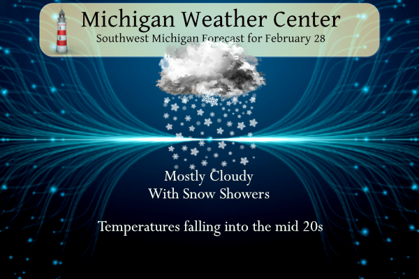
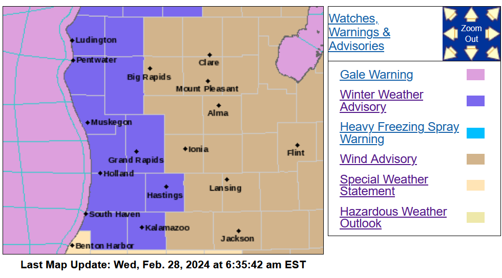
Our high temperature yesterday was a record 75° with a morning low of 55°. Our high today occurred at midnight at 56°. It is currently 32° with light snow falling at 7 am. Temperatures will continue to fall to the low to mid-20s. We have a winter weather advisory for the lakeshore counties and one county to the east. The entire state also has a wind advisory in place.
NWS Forecast
Weather History
1998: Record warm temperatures include the high of 53 degrees at Muskegon and 54 at Grand Rapids, helping to make this the warmest February on record at those sites.
On February 28, 2015, residents of Southeast Michigan woke up to low temperatures of -2 degrees in Detroit, -4 in Flint, and 3 in Saginaw. The low in Detroit was a record for the date, which also rounded out the coldest February on record for Flint (11.3 degrees monthly average temperature) and Saginaw (11.5 degrees). The average in Detroit was 14.1, good enough for its 2nd coldest February on record behind 1875.
Also on February 28, 1974, a tornado hit Wayne County at 5:25 PM. Although the strength of the tornado was not recorded, this is still an impressive event to have happened in Michigan during the winter and is the earliest date of a recorded tornado in southeast Michigan.
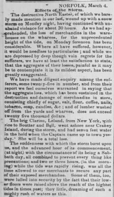
1846: William S. Forrest, in “Historical and Descriptive Sketches of Norfolk and Vicinity” in 1853, recorded the Great Gust of 1846. The Great Gust was a severe coastal storm that produced 5 feet waves in Norfolk. You can read his account of the storm by clicking HERE. The storm is at the bottom of pages 225 to 226.
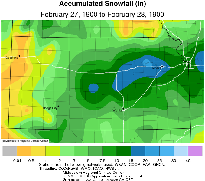
1900: A massive storm produced record snow from Kansas to northwest Ohio and southern Michigan from February 27 to March 01. The observation at the University of Kansas in Lawrence reported 15 inches of snow on the 27th was “phenomenal; only one heavier snowfall has been recorded for any month, a depth of 16 inches on February 11th and 12th, 1894.” (CD). The Coop near Wamego, KS, in the northeast part of Kansas, a record-breaking 24 inches fell in just 12 hours! Other snowfall amounts in Kansas include 19.0″ in Abilene, 18.7″ in Topeka, 18.0″ in McPherson, and 18.0″ in Ellinwood. Topeka saw 17.3″ on February 27, the most recorded in 24 hours.
In Missouri, heavy snow fell over a considerable portion of the state on the 27th and 28th. From Bates, Cass, Jackson, and Platte counties in the west, to St. Charles, Lincoln, Pike, Ralls, Marion, Lewis, and Clark counties to the east, snowfall ranged from 10 to over 20 inches. The snow drifted severely in many places, and where the fall of snow exceeded 10 inches, railroads were blocked, and county roads rendered impassable for several days. A Coop in Darksville, in northern Randolph County, reported drifts from 6 to 8 feet deep in many places. Houstonia Pettis County’s drifts were the worst for more than 30 years. Snowfall amounts in Missouri include 22″ in Miami, 20″ in Richmond, 13.9″ in Columbia, and 13″ in Kansas City and Jefferson City.
The storm probably gave central and northern parts of Illinois some of the highest snowfall totals since 1830-1831. (CD) The Coop in Astoria measured an astonishing 37.8 inches with this storm! Coatsburg saw 26 inches. Other snowfall amounts include 21″ near Normal, 17.5″ in Springfield, and 13″ near Jacksonville.
Heavy snow, freezing rain, and sleet occurred in Indiana from February 28 to March 01. In South Bend, 16″ of snow fell, prompting street-car employees to work all night to keep the tracks open. As a result, railroad traffic was delayed on all lines. Fairmount and Greensburg reported ice and sleet covered the ground on the 28th. Marion, in Grant County, observed the heaviest sleet storm in many years. Some snowfall amounts include 21″ at Valparaiso Waterworks, 18″ in Syracuse, Angola, and Fort Wayne, and 16″ in South Bend and Huntington.
Northwestern Ohio and southern Michigan saw heavy snowfall from February 27 to March 01. The Coop in Wauseon Water Plant recorded 20.5″ of snow. Toledo received 20.2 inches. Grape, Michigan, west-northwest of Monroe, said the heavy snow made all roads impassable. Mail could not be delivered from Grape to Monroe due to badly drifted snow. Some snowfall amounts from southern Michigan include 18″ in Hillsdale, Grape, and Somerset, 14″ in Detroit, 13″ in Lancing, and 12″ in Kalamazoo.
1952: A powerful Nor’easter hit Cape Cod with winds of 70-80 mph and snowfall amounts of 12-20 inches. These conditions created 12-foot drifts.
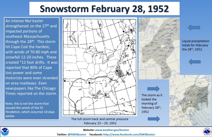
The image above is from a tweet by the NWS Office in Boston, Massachusetts.
1959: In early December 1958, temperatures fell below freezing and remained there until late February. Over 49 inches of snow fell in that time, with very little in the way of melting. The snow absorbed some rain in February and added to the weight on the roof of the Listowel Arena in Ontario, Canada. As a result, the roof collapsed on February 28, 1959, during a hockey game. Seven young players, a referee, and a recreation director (Reginald Kenneth McLeod) were killed in the tragic collapse. Click HERE for more information.

1962: Wilmington, North Carolina, reached a high temperature of 85 degrees. This is the warmest temperature on record during February.
2007: A severe storm named Xynthia blows into France, Portugal, and Spain, smashing sea walls, destroying homes, polluting farmland with salt water, and devastating the Atlantic coast’s oyster farms. Winds reach about 125 mph on the summits of the Pyrenees and up to nearly 100 mph along the Atlantic Coast. Wind speeds of 106 mph are measured atop the Eiffel Tower in Paris. The hardest-hit area was in the Vendee and Charente-Maritime regions in southwestern France. The storm is blamed for 52 deaths in France. In addition, a Napoleonic sea wall collapsed off the coastal town of La’Aiguillon-Sur-Mer. A mobile home park close to the sea wall was particularly hard hit. Click HERE for more information from the BBC.
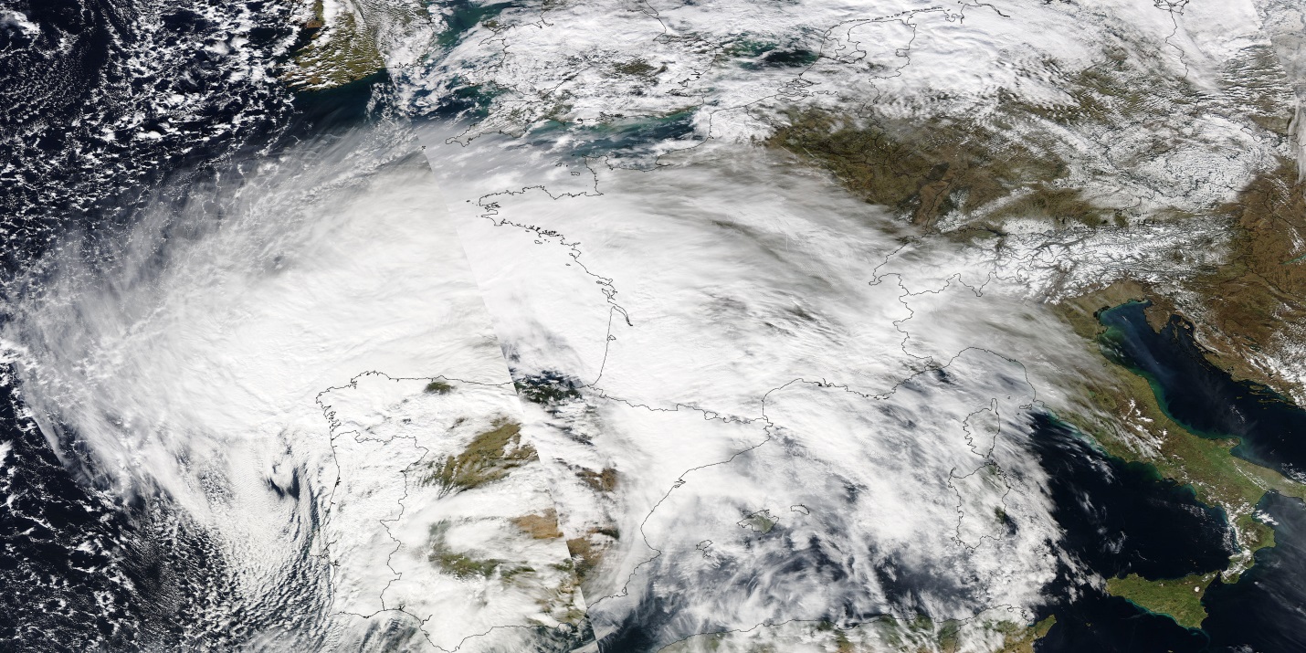
The image above is courtesy of NASA’s Earth Observatory.
2018: A waterspout was seen off the coast of Brixham, in southwestern England.
Forecast Discussion
- Cold front pushing through early this morning

As of 230 am, the cold front stretched from Mount Pleasant,
through Grand Rapids to just west of Kalamazoo. There was still
some instability out ahead of this feature with MU CAPE values
500-1000 J/kg. Effective shear was up over 45 knots so a few
severe storms are possible. Radar does show a few cells tracking
east through Barry County. High Res models show little or no
further convective development through the remainder of the night.
We will keep the severe thunderstorm watch going for where it is
still in effect through 5 am given the recent radar trend of a few
cells developing with along the front. This was coordinated with
SPC.

- Travel Impacts Today

Temperatures drop sharply through the rest of the morning. It was
approaching the freezing mark already near Ludington. Guidance
continues to show snow spreading in through mid morning. Wind
gusts will be ramping up as well as the mixing height deepens. The
combination of falling snow snow and gusty winds will support an
increased potential for low visibilities at times. The HRRR vsby
values shows we could go down to well under a mile at times. This
will add to the travel impacts today. As the temperature falls
through the 20s during the day, roads are likely to transition
from being wet, to icy. Bridges and overpasses will be the first
to cool down and become icy. Model qpf/snow forecasts support the
western parts of the CWA for the most snow, mainly 2 inches or
less. This is where we currently have the winter weather advisory
out and no changes are planned.

- Warming up over the Weekend

Deep warm air advection occurs through the weekend. The
temperature at 925 mb is progged to climb from 6 deg C Saturday to
9 deg C Sunday. Mixing to this level supports max temps in the 50s
for Saturday and 60s for Sunday. The thermal ridge arrives Monday
and that will be another day in the 60s.
It’s a good thing that this winter has been so nice and warm and snow free, that I’ve been able to spend 90% of it outside in the snow free warmth!! I love 2 week winters!!
Just think some people hibernated indoors because they thought it was too cold! Dress for the weather and go take a hike! Wow!
Breaking News!!!!! We just set a record for the largest one day temp drop in history!! Wow just wow, Wow!!!!!!!!!!!!!!!!!!!!!!!
I had a great day in my nice warm office at work today! Beautiful 70 degree weather in there! Looking forward to getting out to the golf course this weekend for a round!! WOW!!
Get ready for highs in the 60’s again this weekend!! Rock on baby!
Get ready for lows in the teens! Rock n roll will never die baby!
What a great winter day! The only thing better would have been more snow, but a 50 degree temp
drop is incredibly amazing! Factor in the wind chill and nearly 70 degrees colder than yesterday!!!!!!!! Wow!!!!!!!!!!!
Currently 22 degrees windchill below 0 end of February crazy 🤪… LETS GO INDY!!
Crazy cold!
Preliminary tornado rating in Calhoun County was high end EF-1
Preliminary tornado rating in Grand Blanc (Near Flint) rated EF-2
At one point yesterday both Van Buren and Kalamazoo Counties had a Tornado Warning, Winter Weather Advisory, Severe Thunderstorm Watch, Severe Thunderstorm Warning in place all at the same time. Hardly ever see that here.
I brought that up to our family we are under a severe thunderstorm watch and winter weather advisory at the same time. LOL!!!
Yeah crazy weather!
For those that weren’t aware I was storm chasing last night. I followed the tornado warned storm from Van Buren County through Kalamazoo County into Calhoun County. It was hailing so hard along I-94 at Battle Creek it accumulated on the freeway. I was on scene of tornado damage just north of the small community of Marengo (Northeast of Marshall). Easily the wildest February severe day I’ve ever seen.
Stay safe out there! I am sure there will be some impressive storms this season!
I want to send a shout out to the SPC and NWS Grand Rapids for handling yesterday’s severe weather event very well!
And according to GRR NWS, the warmth will keep on coming!! Who wouldn’t love 60’s and 70’s this time of year?!?! Golfing at Moss Ridge Sunday sounds like a great plan!!
Deep warm air advection occurs through the weekend. The temperature at 925 mb is progged to climb from 6 deg C Saturday to 9 deg C Sunday. Mixing to this level supports max temps in the 50s for Saturday and 60s for Sunday. The thermal ridge arrives Monday and that will be another day in the 60s.
Yesterday was one of the more notable weather days in history. Warmest meteorological winter day, earliest 70, warmest February day. All historic.
Much colder! Fantastic, because yesterday was way too hot! It should never be 70 degrees in February! Ridiculous!
As Slim mentioned below, February 27, 2024 was a historic day. Both GR and Lansing ended up +32 for the day. The storm that spawned the tornado in Calhoun County caused a tornado warning to be issued for Ingham and Jackson counties about 12:45a. The lightning was brilliant and continuous. Amazing light show. Incredible storm, without question.
The temp has dropped 20 degrees in the past two hours here. It is blustery outside.
Here in MBY there was not much lightning at all. Just a few flashes to the south. So Grand Rapids was north of the big storms last night.
Slim
New record highs were set across Michigan yesterday. All major locations in Michigan set new record highs. The highs were not only the record for the date but also the new record for the month of February and new records for the warmest for any date in meteorological winter. All in all a very historic day.
Slim
There were a few flashes of lightning last night but just 0.17” of rainfall. While most of the night was around 50 it has now fallen to 28 here in MBY.
Slim
The official H/L at Grand Rapids yesterday was 73/50 both were records for the day. There was 0.11” of rainfall the highest wind speed was 38MPH out of the S. The sun was out 71% of the time. For today the average H/L is 38/22 the record high of 60 was set in 2018 and the record low of -12 was set in 2014 the most rainfall of 1.30” fell in 1902 the most snowfall of 9.0” fell in 1900 the most snow on the ground was 18” in 2014. Last year the H/L was 43/33.
Slim