I know a lot of people do not like the time change but none the less tonight is the night we change the time to what I like to call “Winter Time” so don’t forget to change clocks that do not change by themselves one hour back.
MV does a weather history post each week. I will do one with a little different weather history. This is for the week of November 4th to the 10th
Weather History For November 4
1927 – A great Vermont flood occurred. Tropical rains deluged the Green Mountain area of Vermont causing the worst flood in the history of the state. Torrential rains, up to 15 inches in the higher elevations, sent streams on a rampage devastating the Winooski Valley. Flooding claimed 200 lives and caused 40 million dollars damage. The town of Vernon reported 84 deaths. Flooding left up to eight to ten feet of water in downtown Montpelier VT. (2nd-4th) (David Ludlum) (The Weather Channel)
1987 – Thirty-two cities in the eastern and south central U.S. reported record high temperatures for the date. Highs of 74 degrees at Portland ME and 86 degrees at Fort Smith AR equaled November records. It was the fourth day of record warmth for Beckley WV, Memphis TN and Paducah KY. A cold front ushered much colder air into the north central U.S. Gale force winds lashed all five Great Lakes. (The National Weather Summary) It reached 73 in Grand Rapids on November 3rd
1988 – Thunderstorms developing ahead of a fast moving cold front produced severe weather over the Tennessee Valley and the Central Gulf Coast States during the afternoon and evening hours, and into the next morning. Thunderstorms spawned nineteen tornadoes, including eleven in Mississippi. The last of the nineteen tornadoes killed a woman in her mobile home in Lee FL. A tornado in Culbert AL injured sixteen people, and caused two million dollars damage. Thunderstorms also produced baseball size hail in Alabama. Unseasonably hot air prevailed south of the cold front. McAllen TX was the hot spot in the nation with a high of 102 degrees. (The National Weather Summary) (Storm Data)
Weather History For November 5
1894 – The famous Election Day snowstorm occurred in Connecticut. As much as a foot of wet snow fell, and the snow and high winds caused great damage to wires and trees. Winds gusted to 60 mph at Block Island RI. (David Ludlum)
1961 – Strong Santa Ana winds fanned the flames of the Bel Air and Brentwood fires in southern California destroying many homes. At 10 PM the Los Angeles Civic Center reported a temperature of 74 degrees along with a dew point of 5 degrees. On the 6th, Burbank reported a relative humidity of three percent. (The Weather Channel)
Weather History For November 6
1951 – Snow fell from the Texas panhandle to the Lower Great Lakes, leaving record totals of 12.5 inches at Saint Louis MO, and 14.1 inches at Springfield MO. Other heavier snowfall totals included 20 inches at Nevada MO, 13.5 inches at Sedan KS, 13 inches at Decatur IL, and 10 inches at Alva OK. In the Saint Louis area, up to 20 inches was reported in Washington County. (5th- 6th) (David Ludlum) (The Weather Channel)
1987 – High winds in the northeastern U.S., turning a recent warm spell into a distant memory, gusted to 63 mph at Rhode Island. Squalls resulting from the high winds produced five inches of snow at Marquette MI and seven inches at Rome NY. A storm in the southwestern U.S. brought heavy snow to some of the higher elevations of Arizona, Colorado and Utah. (Storm Data) (The National Weather Summary)
1988 – A powerful low-pressure system over the Great Lakes Region continued to produce snow across parts of the Ohio Valley and the Great Lakes Region. Snowfall totals along the shore of Lake Superior reached 24 inches, with three feet of snow reported in the Porcupine Mountain area of Upper Michigan. Marquette MI established a November record with 17.3 inches of snow in 24 hours. (The National Weather Summary) (Storm Data)
Weather History For November 7
1940 – The Galloping Gertie bridge at Tacoma, WA, collapsed in strong winds resulting in a six million dollar loss, just four months after the grand opening of the new bridge. The winds caused the evenly sized spans of the bridge to begin to vibrate until the central one finally collapsed. From that point on bridges were constructed with spans of varying size. (David Ludlum)
1951 – At 7 AM a blinding flash, a huge ball of fire, and a terrific roar occurred over parts of Texas, Oklahoma and Kansas, caused by a disintegrating meteor. Windows were broken in and near Hinton OK by the concussion. (The Weather Channel)
1986 – An early season blizzard struck the Northern Plains Region. North Dakota took the brunt of the storm with wind gusts to 70 mph, and snowfall totals ranged up to 25 inches at Devils Lake. (Storm Data)
1987 – Heavy snow fell across parts of eastern New York State overnight, with twelve inches reported at the town of Piseco, located in the Mohawk Valley. A storm in the southwestern U.S. left nine inches of snow at the Winter Park ski resort in Colorado. Smoke from forest fires reduced visibilities to less than a mile at some locations from North Carolina to Ohio and Pennsylvania. (The National Weather Summary) (Storm Data)
Weather History For November 8
1943 – An early season snowstorm raged across eastern South Dakota and Minnesota into northern Wisconsin. The storm produced 22 inches of snow at Fairbult and Marshall MN, 20 inches at Redwood Falls MN, and 10.1 inches at Minneapolis. Drifts fifteen feet high were reported in Cottonwood County MN. The storm produced up to two feet of snow in South Dakota smothering a million Thanksgiving day turkeys. (6th-8th) (David Ludlum) (The Weather Channel)
1953 – Residents of New York City suffered through ten days of smog resulting in 200 deaths. (The Weather Channel)
1966 – The temperature in downtown San Francisco reached a November record of 86 degrees. (The Weather Channel)
1989 – Afternoon and evening thunderstorms developing along and ahead of a cold front produced severe weather from northern Louisiana into central Georgia. Thunderstorms spawned three tornadoes, and there were sixty-four reports of large hail or damaging winds. A late afternoon thunderstorm in central Georgia spawned a tornado which killed one person and injured eight others at Pineview. Late afternoon thunderstorms in central Mississippi produced baseball size hail around Jackson, and wind gusts to 70 mph Walnut Grove. (The National Weather Summary) (Storm Data)
Weather History For November 9
1913 – The freshwater fury , a rapidly deepening cyclone, caused unpredicted gales on the Great Lakes. Eight large ore carriers on Lake Erie sank drowning 270 sailors. Cleveland OH reported 17.4 inches of snow in 24 hours, and a total of 22.2 inches, both all-time records for that location. During the storm, winds at Cleveland averaged 50 mph, with gusts to 79 mph. The storm produced wind gusts to 80 mph at Buffalo NY, and buried Pickens WV under three feet of snow. (9th-11th) (David Ludlum) (The Weather Channel)
1982 – Seven tornadoes touched down in southern California, three of which began as waterspouts. The waterspouts moved ashore at Point Mugu, Malibu, and Long Beach. The Long Beach tornado traveled inland ten miles causing much damage. (The Weather Channel)
1987 – Showers and gusty winds associated with a cold front helped extinguish forest fires in the Appalachian Region and clear out smoke in the eastern U.S. Thunderstorms produced locally heavy rains from eastern Texas to the Tennessee Valley. Longview TX received 3.12 inches of rain, including two inches in two hours, Tupelo MS was soaked with 2.80 inches of rain. (The National Weather Summary)
1988 – Thunderstorms developing ahead of a strong cold front produced severe weather from eastern Oklahoma to central Indiana. Hail more than two inches in diameter was reported around Tulsa OK. (The National Weather Summary) (Storm Data)
1996 – The Veteran’s Day storm of November 9-14, 1996 may be the most severe early season lake effect snow (LES) storm the Great Lakes has witnessed in the past fifty years. At the height of the storm, over 160,000 customers were without power in Greater Cleveland alone, as the storm produced isolated snowfall tallies approaching 70 . As usual with these LES events, the Veteran’s Day storm battered snowbelt communities downwind of each of the Great Lakes while nearby towns went unscathed. (University of Illinois WW2010) Grand Rapids had a storm total of 2.5”.
Weather History For November 10
1915 – An unusually late season tornado struck the central Kansas town of Great Bend killing eleven persons along its 35 mile track. The tornado destroyed 160 homes in Great Bend killing 11 persons and causing a million dollars damage. Hundreds of dead ducks dropped from the sky northeast of the track’s end. (The Weather Channel)
1975 – Another freshwater fury hit the Great Lakes. A large ore carrier on Lake Superior, the Edmund Fitzgerald, sank near Crisp Point with the loss of its crew of 29 men. Eastern Upper Michigan and coastal Lower Michigan were hardest hit by the storm, which produced wind gusts to 71 at Sault Ste Marie MI, and gusts to 78 mph at Grand Rapids MI. Severe land and road erosion occurred along the Lake Michigan shoreline. A popular hit song by Gordon Lightfoot was inspired by the storm. (David Ludlum)
1987 – A cold front brought snow to the Appalachian Region and freezing temperatures to the central U.S. Up to nine inches of snow blanketed Garrett County of extreme western Maryland. Freezing temperatures were reported as far south as El Paso TX and San Angelo TX. Gale force winds lashed the Middle Atlantic Coast and the coast of southern New England. Thunderstorms brought fire quenching rains to Alabama, and produced large hail and damaging winds to eastern North Carolina. Ahead of the cold front, seven cities in Florida and Georgia reported record high temperatures for the date as readings warmed into the 80s. (Storm Data) (The National Weather Summary)
1988 – Strong winds circulating around a deep low pressure system in southeastern Ontario buffeted the northeastern U.S., with the Lower Great Lakes Region hardest hit. Winds in western New York State gusted to 68 mph at Buffalo, to 69 mph at Niagra Falls, and to 78 mph at Brockport. Four persons were injured at Rome NY when a tree was blown onto their car. (The National Weather Summary) (Storm Data)
1989 – Strong southwesterly winds prevailed along the eastern slopes of the Rockies in Montana and Wyoming. Winds of 80 to 90 mph prevailed across the northwest chinook zone of Montana, with gusts to 112 mph. Unseasonably warm weather accompanied the high winds. Shortly after midnight the temperature at Kalispell, MT, reached a record 59 degrees. (The National Weather Summary) (Storm Data)
1989 – Windy and wet weather prevailed across Washington State. Strong southerly winds gusted to 70 mph at Rattlesnake Ridge, near Hanford. Six rivers in western Washington State rose above flood stage between the 9th and the 11th of the month, following eight days of moderate to heavy rain. Rainfall over the western slopes of the Cascade Mountains between the 3rd and the 10th ranged from 14 to 24 inches. High freezing levels also caused the early snowpack to melt, adding to the runoff in the rain-swollen rivers. Damage was heaviest in Whatcom County, where the Nooksack River caused nearly six million dollars damage, mostly to roads and bridges. (The National Weather Summary) (Storm Data)
2002 – Severe thunderstorms developed ahead of a strong cold front and produced a widespread outbreak of severe weather including many tornadoes. The worst tornado damage was concentrated in Ohio, Tennessee and Alabama. A tornado rated as F-4 on the Fujita Scale struck Van Wert county in Ohio. In Tennessee, the community of Mossy Grove was nearly destroyed by a mile-wide tornado that claimed 12 lives (ENS). A major outbreak of severe weather and tornadoes occurred across the U.S. Tennessee and Ohio valley region on November 10-11, 2002, producing damage in 13 states. A total of 75 tornadoes touched down on Sunday 10th, resulting in at least 36 deaths (ENS).
The official H/L yesterday at Grand Rapids was 57/42 there was 0.01” of rain fall there was no snowfall. It was a windy day with the highest gust of 36 MPH out of the W. There was 53% of possible sunshine. For today the average H/L is 52/36 the record high of 75 was set in 2015. In 2015 we were in the middle of 4 days in a row of highs in the 70’s and then there was one day with a high of 67. 201516 was a very strong El Nino winter. The record low of 15 was set in 1951. 1951 also had the record snowfall for this date of 5.8” The most snow on the ground was 7”in 1991 and 1966. The record rain fall of 1.50” fell in 1959. Last year the H/L was 68/57 and there was 0.11” of rain fall.
AREA FORECAST DISCUSSION
NATIONAL WEATHER SERVICE GRAND RAPIDS MI
337 AM EDT SAT NOV 4 2023
LATEST UPDATE…
SHORT TERM/LONG TERM/MARINE
SHORT TERM
(TODAY THROUGH SUNDAY)
ISSUED AT 337 AM EDT SAT NOV 4 2023
KGRR RADAR TRENDS EARLY THIS MORNING SHOW SHOWERS ARE GRADUALLY
DISSIPATING AND MOVING OUT OF MOST OF OUR AREA. A CONSENSUS OF
LATEST SHORT RANGE ENSEMBLES AND CAMS SUGGESTS THAT THIS TREND
WILL CONTINUE THROUGH DAYBREAK. FAIR WEATHER IS FORECAST FROM MID
MORNING THROUGH THE REST OF THE DAY AS A HIGH PRESSURE RIDGE
GRADUALLY BUILDS IN FROM THE NORTHWEST.
DRY WEATHER WILL CONTINUE TONIGHT THROUGH MOST OF SUNDAY WITH THE
RIDGE STILL IN CONTROL OF THE WX PATTERN. ISENTROPIC UPGLIDE TO
THE NORTH OF A WEAK BOUNDARY OVER CENTRAL LOWER MICHIGAN AND
STRENGTHENING SOUTHERLY FLOW WAA MAY COMBINE TO BRING JUST A FEW
LIGHT RAIN SHOWERS TO OUR FAR NORTHERN FCST AREA BY SUNDAY
AFTERNOON.
LONG TERM
(SUNDAY NIGHT THROUGH FRIDAY)
ISSUED AT 337 AM EDT SAT NOV 4 2023
LONG TERM PERIOD BEGINS WITH A FAIRLY STRONG FALL SYSTEM MOVING
THROUGH THE GREAT LAKES REGION. THE LOW WILL TRACK WELL OFF TO OUR
NORTH HOWEVER, SLIDING EAST ACROSS LAKE SUPERIOR INTO ONTARIO. THE
UPPER SHORTWAVE WILL FOLLOW MUCH THE SAME PATH. PRECIPITATION WILL
BEGIN IN CENTRAL LOWER MICHIGAN SUNDAY NIGHT AND CONTINUE THROUGH
THE DAY ON MONDAY. RAINFALL AMOUNTS WILL VARY SIGNIFICANTLY ACROSS
OUR FORECAST AREA WITH TOTALS OF A TENTH OR TWO ACROSS CENTRAL LOWER
NEAR U.S. 10 TO ALMOST NOTHING ALONG I-94. CHANCES FOR RAIN PEAK
MONDAY MORNING IN THE 60-90 PERCENT RANGE ACROSS MUCH OF OUR AREA.
WEAK RIDGING WILL BRING A BREAK IN THE PRECIPITATION FOR MONDAY
NIGHT AND TUESDAY.
OUR NEXT WEATHER MAKER MOVES IN FOR TUESDAY NIGHT AND WEDNESDAY AS
MULTIPLE WEAK LOW PRESSURE AREAS MOVE OUR DIRECTION FROM THE PLAINS.
THE SOUTHERN LOW MOVES INTO THE SOUTHERN GREAT LAKES ON WEDNESDAY
AND WILL BE THE PRIMARY DRIVER OF OUR WEATHER (CLOUDS AND RAIN).
RAIN LOOKS LIKELY ON WEDNESDAY AS THE LOW MOVES IN WITH OUR FORECAST
CARRYING (60 PERCENT) VALUES FOR RAIN SHOWERS OVER MUCH OF THE
FORECAST AREA. RAIN CHANCES WILL LINGER INTO WEDNESDAY NIGHT AS WE
WILL REMAIN IN CYCLONIC UPPER FLOW AND WEAK TROUGHING.
FOR THURSDAY INTO FRIDAY MODEL DISPARITY SHOWS UP BETWEEN THE
OPERATIONAL ECMWF AND THE GFS. BOTTOM LINE WE CONTINUE WITH UPPER
TROUGHING, BUT THE ECMWF BRINGS IN A SYSTEM OUT ON FRIDAY. WE HAVE
TIME TO SORT THIS OUT, BUT FOR NOW WE ARE CARRYING SMALL CHANCES FOR
RAIN SHOWERS.
AS FAR AS TEMPERATURES GO, AFTER A WARM MONDAY IN STRONG SOUTH FLOW
WE TURN BACK TOWARDS MORE NORMAL TEMPERATURES IN THE 40S AND 50S FOR
HIGHS.
Detailed Forecast For Grand Rapids
Today
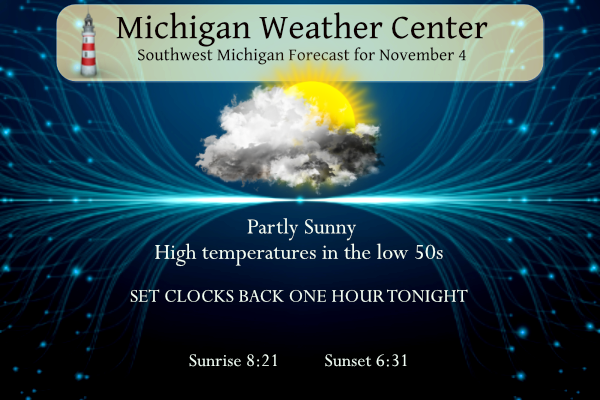
Mostly cloudy, with a high near 52. East northeast wind 3 to 7 mph.
Tonight
Partly cloudy, with a low around 33. North wind around 6 mph becoming calm in the evening.
Sunday
Increasing clouds, with a high near 51. Light and variable wind becoming southwest 5 to 10 mph in the morning.
Sunday Night
A 40 percent chance of showers after 2am. Mostly cloudy, with a low around 43. South wind 8 to 15 mph.
Monday
Showers, mainly between 8am and 2pm. High near 57. Breezy, with a southwest wind 24 to 26 mph, with gusts as high as 39 mph. Chance of precipitation is 90%.
Monday Night
A 30 percent chance of showers before 8pm. Partly cloudy, with a low around 42. Breezy.
Tuesday
Mostly cloudy, with a high near 48.
Tuesday Night
A chance of showers after 2am. Mostly cloudy, with a low around 35.
Wednesday
Showers likely, mainly after 2pm. Cloudy, with a high near 45.
Wednesday Night
Showers likely, mainly before 2am. Cloudy, with a low around 39.
Thursday
A chance of showers. Mostly cloudy, with a high near 46.
Thursday Night
A chance of showers. Mostly cloudy, with a low around 36.
Friday
A chance of showers. Mostly cloudy, with a high near 43.
Thanks Slim. Amazing weather today! Perfect for finishing up the landscaping around our new restaurant. With the sun and no wind we were actually getting hot spreading stone, does not feel like November at all.
Barry when does your new restaurant open?
We’re hoping for around mid December if everything goes smoothly, but if it gets pushed to January that’s fine to. It’s been a long road but we can see the opening coming!
I’ll be in Miami the next 10 days… I actually really like this time of year in Michigan, kind of wish the trip was in January-March. But it’s my first “vacation” in about a year, so looking forward to it!