Though not impossible it is beginning to look like accumulating snow of any consequence is becoming less and less as we travel further into spring. Our last snows were on the 23rd and 27th of February with an inch and a half between the two. We received around a tenth of an inch of rain yesterday morning which was our first precipitation since February 27th. Overall we have had a dry and sunny pattern through the first ten days of March.
La Nina is fading away to neutral and is predicted to continue to do so through the spring. In the neutral state (neither El Niño nor La Niña) trade winds blow east to west across the surface of the tropical Pacific Ocean, bringing warm moist air and warmer surface waters towards the western Pacific and keeping the central Pacific Ocean relatively cool.

Consensus agrees with this transition and then predicts a continuation of ENSO-neutral at least through the Northern Hemisphere summer. In part, due to the uncertainty in predictions made at this time of year, the forecast for September-November remains lower confidence with a 45-50% for La Niña and 40-45% for ENSO-Neutral, with a low chance for El Niño. In summary, there is a ~60% chance of a transition from La Niña to ENSO-Neutral during the Northern Hemisphere spring of 2021.

The overall dry pattern has affected most of the U.S.. Here in SW Michigan, we have received about 50% of our normal rainfall
I am not even going to try to guess what the neutral cycle will bring as we go into summer as forecasting that far into the future can be fickle even when we try to throw in words like ‘normal’. What is normal anymore?
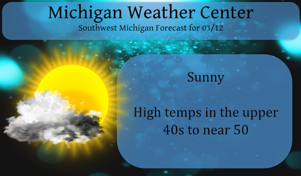
Winds will subside this evening with the gustiness of the wind ending near or shortly after sunset. High pressure will gradually build into the Great Lakes region on Friday and remain in place over the weekend. This will ensure dry weather and plenty of sunshine over the next 3 days. Highs Friday through Sunday will be in the 40s, which is closer to normal for this time of year.
As a reminder, don’t forget to set your clocks ahead Saturday night/Sunday morning. I suppose we believe we are masters of time when we have such power over the clock. 🙂
Forecast Discussion:
-High pressure and fair weather through the weekend

Surface high builds in today and holds sway into early next week.
Dry weather until at least Sunday night.

-Low pressure brings chances of mixed precip next week

There are two low pressure areas to watch next week. The first is
forecast to weaken as it approaches from the southwest on Monday
with a wintry mix possible Monday morning across the southwest
forecast. This area of mixed precipitation spreads north and
weakens by Tuesday as the low occludes and dry air continues to
feed into Lower Michigan on easterly flow. This is a favorable
synoptic setup for freezing rain so we will have to monitor that
potential as we get closer to the event.

A second low forms over the Southern Plains quickly in the wake
of the first one, and tracks northeast. There is a lot of spread
in the track of the low with the blended forecast weighted toward
the GFS which keeps the precip south of Lower Michigan. There is
some model guidance showing this low tracking further north and
bringing rain or snow into Lower Michigan by Thursday.
Alpine golf club open!! Might have to go play 9 or so Saturday and Sunday!! Golf in the first half of March?!??!? BRING IT!!! I love front loaded Springs!!
Horrible weather and conditions for golf! You are desperate! No grass is even growing yet! Ridiculous! I may head to snow country for more skiing! Now that sounds like fun!!
Sounds awful!! You’re desperate, driving 4 hours north to ski on man made slush! I’d rather golf 10 minutes from my house!
March and April are Winter months. More than enough snow and cold on the way.
You know it, in fact we will be seeing more accumulating snow this month! Get ready now!
The official overnight low at GRR was 33 here at my house the low was 28. At the current time with clear skies it is now 36 here. There has only been a reported trace of snow fall this month at Grand Rapids and GR remains at 45.8″ of total snow fall for the season and now is over 23″ below average as of this date. Todays sun angle is the same as it is on October 1st and now the time between sun rise and sun set is 11h 45m and gaining 3 minutes a day.
Slim
For the first 11 days of March, GR is +5.9 degrees above average with tons of sun and no snow. I love early springs!
It is one of the sunniest starts to any March.
Slim
31* degrees in my area this morning the crisp frost looks good outside the air is fresh!! Now we made it to mid March and still no thunderstorms the Spring drought continues….. Have a super Friday GO BLUE!! INDY
Wednesday was a rare day with a departure from average of over 20 degrees at 24 above average. Yesterday was close as well being 17 degrees above average. Lots of long time records falling by the wayside.