Our high for today was 62° at midnight and has fallen to 58 at 6 am which feels like a warm summer early morning. We didn’t quite make it to 70° yesterday here in Otsego, my digital reading was 68° for yesterday’s high. With the exception of the lakeshore area temps are consistent in the upper 50s to low 60s currently. Rainfall totals are just a few hundredths over southern Michigan.
Temps will continue to fall during the day to the upper 40s to low 50s.
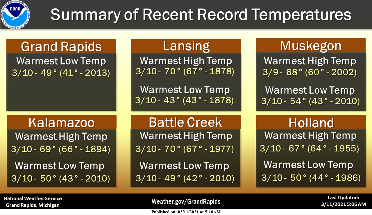
All of our official sites broke at least one record over the last couple of days, with most sites breaking two records. Record high temperatures and record warm lows were both set. The very warm weather for this time of the year is over for the time being.
[columns] [span6]
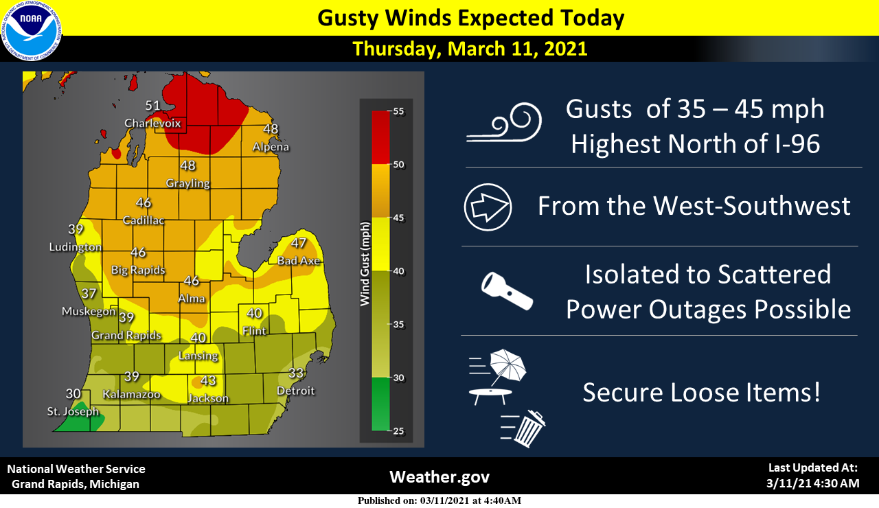
Although winds will relax a bit at the lakeshore today, they’ll be gusting to 45 or 50 mph north of Interstate 96.
[/span6][span6]
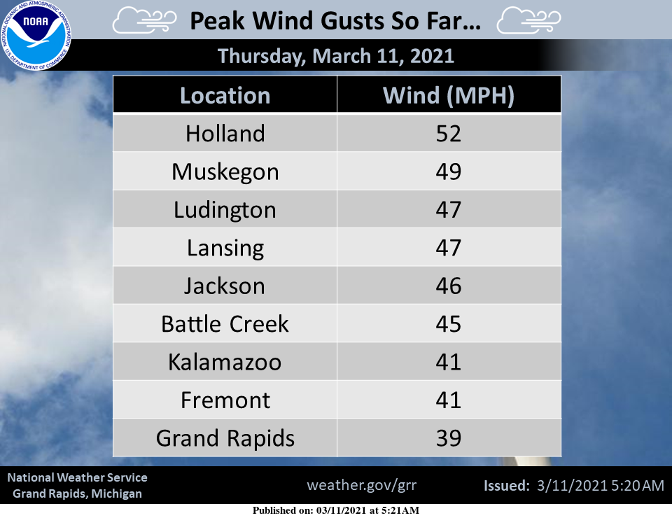
Here’s a list of some recent peak wind gusts from around the area.
[/span6][/columns]
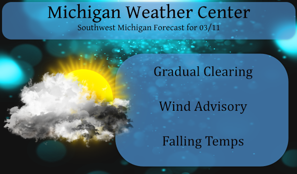
Forecast Discussion
--Windy with showers today--

We`ve recently expanded the Wind Advisory to include areas north
of I-96 and it will be in effect until 6 PM this evening. This is
for the stronger gusts which are expected to occur behind this
morning`s cold frontal passage. Deeper mixing will develop by
afternoon as skies clear out behind the front, aiding in momentum
transfer of the 40-45 kt WSW winds up around 2-3K ft AGL. Winds
diminishing quickly this evening as the boundary layer decouples.

Meanwhile the original Wind Advisory along the Lake Michigan coast
should be okay to expire at 7 AM. We`ve been seeing frequent
gusts of 45 to 50 mph at BIV, MKG and LDM in the warm and mixy
southerly flow immediately adjacent to the cold marine layer.
However as the wind direction goes more southwesterly this morning
behind the cold front then west this afternoon the stable marine
layer will spread in from Lake Michigan. The cooler sfc temps will
lower the mixing depth and gusts should lower into the 30s along
the lakeshore this morning.

Otherwise a period of rain showers is likely as the sfc cold
front drags through the area this morning. Rain amounts will be
on the light side with most areas seeing less than a quarter inch
and only lasting a few hours at any location. Skies turning mostly
sunny from northwest to southeast behind the front, with JXN
being the last the clear out toward mid afternoon.

--Dry and cool Friday through Sunday--

Breezy conditions developing again on Friday by mid to late
morning, especially inland from Lake Michigan. Cooler high temps
are expected, ranging from only 40 to 45 over western and
northern sections of the area to near 50 at LAN and JXN. Then some
very chilly overnight low temps of 15 to 25 are forecast for
Friday night as a 1035 mb sfc high settles directly over Lwr MI.
That surface high continues to influence our weather over the
weekend with dry and mainly clear conditions. However increasing
high level cloudiness from the southwest may occur on Sunday.

--Wintry mix possible early next week--

Big closed upper low over the SW United State/Four Corners region
begins lifting our way early next week but will be encountering
dry air and a confluent flow aloft as it does so. This leads to
some uncertainly in how soon any precip arrives and how much we`ll
see, and also questions regarding precip type due to wet bulbing
related to the lingering dry air in the low levels. Will need to
carry a chance of a wintry mix for early next week as waves of
precip associated with the upper low attempt to invade the area.
Bye bye snow.. Lol !!
Wow 48* degrees in my area now so longggggggg 60’s lol …INDY
Incredibly mild 62 degrees this morning, as for rain not sure if we got any as there was nothing registered in the gauge. Looks like the groundhogs prediction a month ago was a ways off base as there hasn’t been a sniff of Winter in weeks now.
For the 2nd day in a row the official high of 67 yesterday came in as the 2nd warmest high for the date. The official low for March 10 of 49 is the warmest low for the date and one of the warmer lows for the month of March. At this time it is mostly cloudy here and the temperature is now down to 52 here. I recorded .05″ of rain fall here.
Slim
Plenty of upper 40’s and 50’s in the foreseeable future!! Looking great!!!
https://weather.com/weather/tenday/l/b4ea0280869baa46799dc75eacef8904785ec43ad2f6fb098355fbc208a55e2c
Wow, 62 degrees overnight. That makes today our third straight day in the 60’s!
Lots of places in Michigan made record highs in the 70’s yesterday!
Woke up to beautiful warm temps and ALL snow gone, all around my house, even the gross piles of snow! Felt like a summer morning out! I love front loaded AND back loaded springs!!
This looks very promising!!
https://www.instantweathermaps.com/GFS-php/conussfc.php?run=2021031106&time=PER&var=ASNOWI&hour=312
What happened to all this supposed snow that was coming the back half of March?