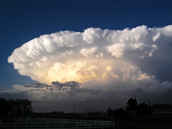
On the thunderstorm spectrum, supercells are the least common type of thunderstorm, but they have a high propensity to produce severe weather, including damaging winds, very large hail, and sometimes weak to violent tornadoes. What makes a supercell unique from all other thunderstorm types is that it contains a deep and persistent rotating updraft called a mesocyclone. If the environment is favorable, supercell thunderstorms can last for several hours.
Although supercells require some degree of buoyancy, moderate to strong speed and directional wind shear between the surface and about 20,000 feet is the most critical factor. Wind shear not only creates the mesocyclone, but it also allows the storm to be tilted, which is important for maintaining a separate updraft and downdraft region. A separate updraft and downdraft allows the supercell to be long-lived because it reduces the likelihood that too much rain-cooled, stable air from the downdraft region will be ingested into the updraft, causing the storm to weaken.

Supercells are responsible for nearly all of the significant tornadoes produced in the U.S. and for most of the hailstones larger than golf ball size. Supercells are also known to produce extreme winds and flash flooding.
They are highly organized storms characterized by updrafts that can attain speeds over 100 mph (160 km/h) and are able to produce giant hail with strong or even violent tornadoes. Downdrafts produced by these storms can produce downbursts/outflow winds in excess of 100 mph (160 km/h), posing a high threat to life and property.
The most ideal conditions for supercells occur when the winds are veering or turning clockwise with height. For example, in a veering wind situation the winds may be from the south at the surface and from the west at 15,000 feet (4,500 meters). This change in wind speed and direction produces storm-scale rotation, meaning the entire cloud rotates, which may give a striated or corkscrew appearance to the storm’s updraft.
Dynamically, all supercells are fundamentally similar. However, they often appear quite different visually from one storm to another depending on the amount of precipitation accompanying the storm and whether precipitation falls adjacent to, or is removed from, the storm”s updraft.
Based on their visual appearance, supercells are often divided into three groups;
- Rear Flank Supercell – Low precipitation (LP),
- Classic (CL), or
- Front Flank Supercell – High precipitation (HP).
In low precipitation supercells the updraft is on the rear flank of the storm providing a barber pole or corkscrew appearance to the cloud. Precipitation is sparse or well removed from the updraft and/or often is transparent.
Also, large hail is often difficult to discern visually. With the lack of precipitation no “hook” seen on Doppler radar.
The majority of supercells fall in the “classic” category. The classic supercell will have a large, flat updraft base with striations or banding seen around the periphery of the updraft. Heavy precipitation falls adjacent to the updraft with large hail likely and has the potential for strong, long-lived tornadoes.
High precipitation supercells will have…
- the updraft on the front flank of the storm
- precipitation that almost surrounds updraft at times
- the likelihood of a wall cloud (but it may be obscured by the heavy precipitation)
- tornadoes that are potentially wrapped by rain (and therefore difficult to see), and
- extremely heavy precipitation with flash flooding.
Beneath the supercell, the rotation of the storm is often visible as well. The is visible as a lowered, rotating cloud, called a Wall Cloud, forms below the rain-free base and/or below the main storm tower updraft. Wall clouds are often located on the trailing flank of the precipitation.
The wall cloud is sometimes a precursor to a tornado. If a tornado were to form, it would usually do so within the wall cloud.
With some storms, such as high precipitation supercells, the wall cloud area may be obscured by precipitation or located on the leading flank of the storm.
Wall clouds associated with potentially severe storms can:
- Be a persistent feature that lasts for 10 minutes or more
- Have visible rotation
- Appear with lots of rising or sinking motion within and around the wall cloud
It would be nice if we got some storms this year.
Our perennials are popping up. Baseball season has started. March Madness. Spring Break. I love this time of year.
Wow, it’s really warming up again today in that sun! I can’t believe how sunny this week has been for March in Michigan.
Hey while it is not official I have just reached 60 here at my house. Will now have to see if the airport does.
Slim
At 2pm, GR is at 51 – already warmer than the average high. South Haven is at 56. Another run of 60’s in Michigan today?
It is now 56 here at my house.
Slim
WOOD has raised temps in their 8-day forecast once again! This weekend really doesn’t look that bad and then we’re right back to above average.
In doing some research for Saturday’s post I compiled some information that I will toss up now and it will also be in tomorrows post. I noticed there is some discussion as to just how warm/cold 2019 has been so far. Well here are the members as of Mach 28th January temperature departure at Grand Rapids -2.6° at Lansing -2.5° at Muskegon -2.7° snow fall Grand Rapids 30.5” average 20.8” Lansing a incomplete 4.3” reported (several snowy days reports are missing) average 13.8” Muskegon 32.9” average 28.0” February temperature departure Grand Rapids -1.2° Lansing -0.7° Muskegon -1.2° Snow fall Grand… Read more »
WWM TV channel 3 is having a spring storm special April 20th I’m thinking that’s a little late we may see severe storms before then! INDY!
Hats off to MV for some very good information on thunderstorms this week. So far Grand Rapids, Lansing and Muskegon have reported 1 day of thunder. Note the NWS only keeps records of “thunderstorm day’ and not the number of thunderstorms that happen so if a day has more then one thunderstorm it is still counted as a thunder day. Also if it only thunders once it also still counts as a thunder day.
Slim
Good read again MV! Learned several things I did not know. Last Summer we got to view a supercell storm in Colorado from up in the mountains looking back towards Denver. It was clear by us and the storm was probably 50 miles away, but it was impressive to watch, especially as it got dark with the non stop lightning.
We are clearly in a below normal temp pattern since the beginning of this year and there is no sign of any change in the near future! Sorry but the facts are getting in the way of mookies warm weather propaganda again! Incredible!
Maybe the 3rd or 4th week of January, but not the beginning of the year. We didn’t even have any snow till the end of January. That was incredible!
at all 3 major reporting locations all 3 months so far in 2019 have seen temperatures below average.
Slim
No, I meant the first couple weeks of January, not the month as a whole. Before the really cold air came in at the end of the month, we were above average temp wise. He/she said we’ve been below since the beginning of the year, but it only started when it dropped below zero during that one week.
That is true Barry, The first 20 days of January were indeed not only mild but almost snow free as well. At that time I really thought GR would have a very mild and much below average snow fall for the winter season.
Slim
Wow wrong again!
Yes you are!
My furnace kicked on last night Still cold overnight once we bounce that off I will be happy …INDY!!
Your furnace will be working full time this weekend and into next week! Get ready!
I don’t know how many thunderstorms that Grand Rapids had last spring/summer but I know there were not a whole lot. We will have to see if that continues this year. Unless today way over performs it looks like 61° will be the warmest it officially gets in Grand Rapids this March. (I had a high of 63 yesterday but that don’t count)
Slim
My car read 66 leaving work in Portage around 3:15pm…unofficial, but felt great:).
Starting Saturday it looks like we are in for another multiple day stretch of below normal temps! It will last at least through Wednesday and maybe longer! The cool pattern just keeps going and going! Incredible!
False. This week has been above average in aggregate so far.
It’s not nice to use terms that Rocky may or may not understand LOL
Slim
Too funny!
Next week is shaping up to be a lot like this past week – and maybe even warmer too! I love this time of year.
Get ready for a cold windy weekend! Forget golf, forget working in your yard, etc!
Lol it’s the only thing you’ve been talking about for the past 5 days even though we just had an incredible week of sun and awesome temps! Talk about cold bias
Forgot to mention we hit 64* yesterday – makes two 60 plus days this month.