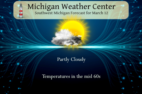
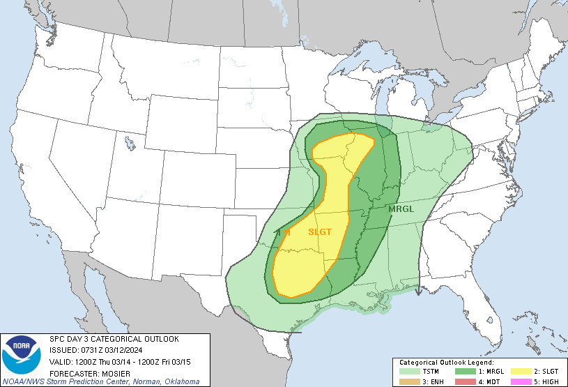
Yesterday we reached 62° with sunny skies. Another mostly sunny and warm day is in store for Today with highs in the mid-50s closer to Lake Michigan, to mid-60s inland. Rainshower chances will increase later Wednesday, with a rumble of thunder possible. Conditions will then remain wet and unsettled into the weekend with cooler temperatures. Below is the SPC outlook for Thursday and Friday.
NWS Forecast
Weather History
1976: A tornado outbreak struck from Michigan to Alabama. At least four tornadoes hit Michigan with nine people injured. Two tornadoes hit Jackson County, with damage to several homes and businesses. One person was injured in Ottawa County as a tornado moved from north of Holland to north of Hudsonville.
On March 12, 2014, a moisture-laden winter storm tracked across the area bringing a swath of 6 to 10 inches of snowfall to areas along and south of I-69. The heaviest band of snow fell roughly along the M59 corridor where 8 to 10 inches was observed. Driving conditions quickly deteriorated as gusty winds over 40 mph ushered in much colder air resulting in freezing and drifting of snow on area roads.
Also on March 12, 2012, thunderstorms produced a rare March tornado just southeast of the town of Coleman. Rated an EF1, it was tied for the second earliest tornado to be recorded in Southeast Michigan since 1950 and only the 10th March tornado on record. It would be the first of four to occur during the month.
Also on March 12, 2009, as a result of heavy rainfall between the 7th and 11th, flooding was observed on several rivers in Southeast Michigan. Three or more inches of rain fell across a good portion of southeast lower Michigan with the River Raisin basin getting hit the worst with 4 to 5 inches in that period. The flooding reached moderate flood stage on the Huron at Hamburg and the reach from Blissfield down to Monroe got to moderate to major flood stage. Dundee recorded its 3rd highest crest ever. Many roads and homes along the Raisin were flooded.
1928: The St. Frances dam near Santa Paula, California, burst before midnight, sending 138,000 acres of water rushing down the San Francisquito Canyon, killing 450 people. The dam was designed and built between 1924 and 1926 by the Los Angeles Department of Water and Power, then named the Bureau of Water Works and Supply.
1976: A massive tornado outbreak spawned tornadoes in the Great Lakes and Midwest, including 9 in northern Indiana and extreme southern Michigan. A tornado missed President Ford’s motorcade by a quarter-mile near O’Hare. The next morning, he got out of his vehicle to view the damage.
1993: An incredible blizzard known as “The Superstorm” struck the eastern United States on this date through the 15th. The storm was described as the most costly non-tropical storm ever to hit the U.S., doing an estimated $6 billion in damage. The storm was as strong as a hurricane regarding winds and low pressure. The pressure dropped to an incredible 28.35 inches of mercury or 960 millibars when then the storm was located over the Chesapeake Bay. Boston, Massachusetts, recorded a wind gust of 81 mph, the most substantial wind they had recorded since Hurricane Edna in 1954. Also, as the storm was intensifying over the Gulf of Mexico, a wind gust of 99 mph was recorded by an offshore oil rig. It dumped incredible amounts of snow from Alabama to New England. The snow amounts were significant everywhere, but for places like Birmingham, Alabama, the 17 inches recorded brought the city to a standstill for three days. Mount Leconte, North Carolina, recorded 60 inches of snow. Practically every weather station in West Virginia established a new 24-hour snowfall record during the event. Syracuse, New York was buried under 43 inches of snow. The storm killed 220 people, and another 48 lost at sea. The storm also brought a 12-foot storm surge and 15 tornadoes to Florida, where 51 people were killed. Air travel was brought to a halt as every major airport from Atlanta north was closed during the height of the storm. During the late evening into the early morning hours of the 13th, a vicious squall line swept through Florida and spawned 11 tornadoes resulting in five fatalities. Thunderstorm winds gusted to 110 mph at Alligator Point and 109 mph at Dry Tortugas. Exceptionally high tides occurred along the western Florida coast. A 13-foot storm surge occurred in Taylor County, Florida, resulting in 10 deaths with 57 residences destroyed. A 5 to 8-foot storm surge moved ashore in Dixie County. Over 500 homes were destroyed, with major damage to another 700 structures.
Forecast Discussion
- Mild and Dry Through Wednesday Afternoon

South to sw flow waa continues and will increase today as it
becomes fairly windy. This in conjunction with a good deal of sun
will help to boost high temps into the low to mid 60`s across most
of our area. The exception to this is near the Lake MI shoreline
where it will be significantly cooler given a component of winds
off cold Lake MI waters.

Mild and dry wx continues Wednesday with high temps across our
area very similar to today. An isolated light rain shower or
sprinkle may develop over our southern fcst area as early as
Wednesday afternoon due to isentropic upglide north of the warm
front.

- Showers and Some Storms Likely Late Wednesday into Friday

Thunderstorm chances for this timeframe have increased compared to
the forecast from this time yesterday. Specifically, Thursday
afternoon and evening have greater probabilities with a greater
northward extent, reaching into central Lower MI. QPF looks
consistent, generally reaching the 0.25-0.75 inch range by Friday
with a roughly 10 percent chance of exceeding an inch. As noted
previously, localized fgen-assisted amounts of 1.5" or greater
remain possible. But again, this is over the course of a couple days
or more, so precipitation intensity should be quite manageable.


Latest available guidance continues to advertise limited shear and
instability, keeping the northern edge of the severe threat close to
the Indiana state line for now. However, when dealing with warm
fronts, destabilization often overperforms thanks to robust low
level theta-e advection and isentropic ascent, so would not be
surprised to see some kind of risk shifted north to at least the I-
94 corridor as we get closer to the event.

- Unsettled and Colder This Weekend

We still expect broad upper troughing to drop into the area this
weekend, but now it appears there may be a leading compact upper PV
max that could introduce PoPs to the area Saturday and Saturday
night, especially for central and northern Lower Michigan.

After this, the upper trough becomes established with deep cyclonic
flow, low level cold advection, and the upper jet positioned south
of the forecast area. Dynamically, this is a favorable setup for
lake effect precipitation. Moreover, there is a signal for MUCAPE
developing over southern Lake MI, which also supports lake effect.
Temperatures at 850 mb look to be around -10C or warmer, which is
only marginally supportive of effective crystal growth for lake
effect snow. Nonetheless, the synoptic setup does favor at least
some accumulations near the lakeshore Monday morning for our
southwestern zones.
Enjoy tomorrow because after that we have rain, wind, cold, with high temps in the 30’s! WOW, the just wow, WOW! Cold, cold, cold!!
How many +20 degree days or better can we get in such a short time?! I keep having to look at the date to verify we are actually in March yet.
66f in Petoskey today! Wow. Stores had signs, “snowshoe sale due to the winter without snow”. I wonder how big of a hit places took that rely on winter tourism.
Cross country skiing was bad, snowshoeing was bad, ice fishing festivals were cancelled! It was a horrible winter!
WOOD has 27 degrees for a high next Wednesday. I am betting this will turn out to be very wrong. Not sure why WOOD always does this.
Oh yeah, Kirkwood wishcast big time there!
Chief Ellen fixed it. She now has 49 for a high Wednesday. She probably let Kirkwood have it for that one.
Some interesting information on the sun altitude (that I thought of, but I’m sure it is published on the internet somewhere). If you do 90-(current latitude) then this will give you the sun angle on the equinox. So we are 90-43 = 47. And because the earth is about titled 23 degrees, add or subtract 23 to get the height on the solstice. So the winter solstice we are 24 degrees, summer we are 70 degrees. Works for anywhere
I’m confused. What if we lived at 20 degrees north? 90-20= 70. Then add 23 equals 93 degrees?
If you are within the Tropic of Capricorn or Cancer then the sun will pass over you at some point… so good point, for those locations if you go *over* 90 degrees, then it loops back down. So 93 degrees is really 87 degrees. It’s more straightforward for us in GR
I have a question about the eclipse coming up. Will we be able to see anything if we don’t drive any where here in SW Michigan? I was looking at eclipse glasses and didn’t know if it would be worth purchasing some.
Thanks for all your help. Plus, I know weather will play a big role.
You will need glasses to look at he sun in Michigan. Here is the percentage of the sun that will be covered at it peak. Grand Rapids 93.6% Detroit 99.4% Ann Arbor 98.8% Lansing 96.1% At the Michigan Ohio border on I 75 100% for around 1 minute. I am going to Bucyrus Ohio where it will be 100% for 3M 48S
Slim
Thanks Slim…
I saw something with 2 pairs of glasses and covers for your phone for $17… $4.99 to ship… But they are made in US and NASA approved.
Can anyone recommend any… l saw some on amazon… would those work?
Yep, I think my wife and I are going to Sandusky, OH
We drove down to the bottom of Illinois to view the last total eclipse a few years back, and I will say if you at all have the opportunity to drive to see the upcoming eclipse DO IT! It has to be one of the most amazing things I’ve ever seen, almost impossible to describe. We are driving to Ohio to see the upcoming one, or driving to wherever the skies are forecast to be clear.
What glasses are you all using..I do t have access to welding helmets anymore. Boo!!
I bought several sets back before the last eclipse, not sure where I ordered them from. My guess would be Amazon? They are legit and worked perfectly.
Thanks Barry… I think we got some from tht library..but no idea where they are. Lol
The warm temperatures so far this spring has everything about a month ahead of schedule. I now have crocuses and daffodils in bloom. There are also many trees with buds on them. We will have to see how this will play out in the days ahead.
Slim
The official H/L yesterday was 61/29 there was no rain/snowfall. The highest wind gust was 44 MPH out of the SW. The sun was out 91% of the time. For today the average H/L is 43/26 the record high of 76 was set in 1990 the record low of 2 was set in 1948 and 1993. The most rainfall of 2.35” fell in 1902 the most snowfall of 3.2” fell in 1923. The most snow on the ground was 11” in 2014 and 1978. Last year the H/L was 32/26 there was 0.9” of snowfall.
Slim