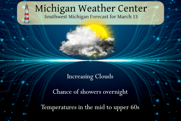
Yesterday we had an early summerlike temperature of 71°. Today will be another very warm day with low humidity and less wind than the past couple of days. Highs are expected to be in the 60s, possibly in the low 70s once again which is about 20 degrees above normal. Some clouds will return especially later in the day. Precipitation finally returns to the forecast with good chances for showers and thunderstorms Thursday and Thursday night into Friday morning.
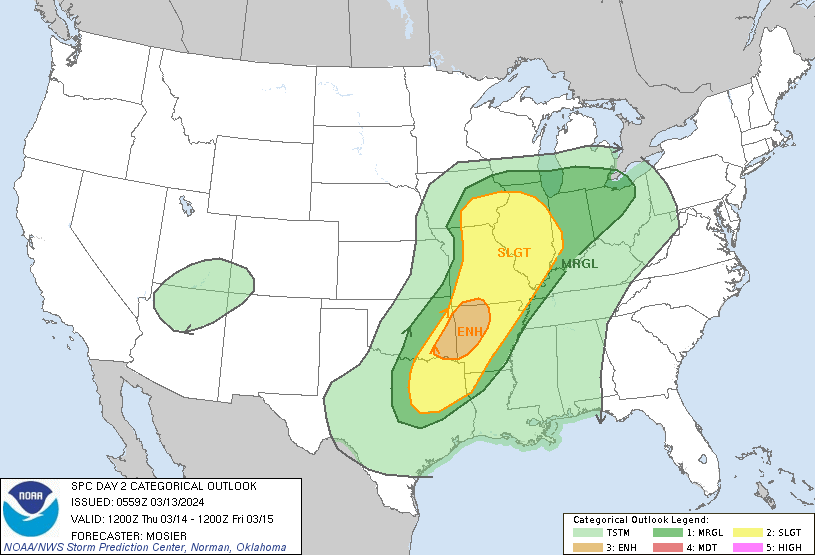
SPC Day Two Forecast
NWS Forecast
Weather History
1990: A spell of record warm weather continues across Lower Michigan with temperatures in the 70s. Lansing hits 74 degrees during a string of four straight days in the 70s.
1993: The Superstorm of 1993 dumps three to four feet of snow across the Appalachians and draws down record-cold arctic air across Lower Michigan. High temperatures struggle to reach the lower 20s with gusty winds making it feel even colder.
On March 13, 2017, a clipper brought widespread 1 to 2 inches of snow accumulation to SE Michigan. With the easterly wind off of Lake Erie, lake enhancement led to a small area of 3 to 6 inches in the Detroit Metro area. Thousands of area residents were still without power during this event due to the record March 8th wind storm a few days prior.
Also on March 13, 1990, the overnight temperature dropped to only 59 degrees in Flint, which is the record maximum low temperature for the day. This was also the second day in a string of four days (March 12-15) that record maximum low temperatures were set.
1953: An F4 tornado cut an 18-mile path through Haskell and Knox counties in Texas. 17 people were killed, and an eight-block area of Knox City was leveled.
1989: Residents of the southern U.S. viewed a once-in-a-lifetime display of the Northern Lights. This solar storm also caused the entire province of Quebec, Canada, to suffer an electrical power blackout.
1990: Thunderstorms produced severe weather from northwest Texas to Wisconsin, Iowa, and Nebraska during the day and into the night. Severe thunderstorms spawned 59 tornadoes, including twenty-six strong or violent tornadoes, and there were about two hundred reports of large hail or damaging winds. There were forty-eight tornadoes in Kansas, Nebraska, and Iowa, and some of the tornadoes in those three states were the strongest of record for so early in the season, and for so far northwest in the United States. The most powerful tornado of the day was one that tore through the central Kansas community of Hesston. The F5 tornado killed two persons, injured sixty others, and caused 22 million dollars in damage along its 67-mile path. The tornado had a lifespan of two hours. Another tornado tracked 124 miles across southeastern Nebraska, injuring eight persons and causing more than five million dollars in damage during its three-hour lifespan. Click HERE for more information from the NWS Office in Wichita, Kansas.
Forecast Discussion
- Mild Today

A consensus of latest shorter range high resolution guidance as
well as ensemble numbers suggest that it will be quite mild again
today. High temperatures will again reach well into the 60s given
quite a bit of sun and coming off relatively mild mins early this
morning for this time of year.

- Showers and Storms Late Tonight Through Thursday Evening

The 00Z HREF corroborated with CAMs suggest that showers and
thunderstorms will develop tonight due to isentropic upglide in
conjunction with weak elevated instability to the north of the
warm front. The warm front tonight will extend from west to east
across northern IL/IN/OH to near the MI/IN border by 12Z Thursday.
Any scattered convection should stay near to mainly south of the
I-96 corridor where weak elevated instability will be present.
Further north we expect just more stratiform type scattered
showers. No severe wx tonight given only weak elevated instability
and no sfc based instability.

A better chance for convection across most of our area (and
especially over the southern half of our fcst area) will come
Thursday morning and afternoon as the warm front lifts slowly
north.

Warm frontal position Thursday is key to this fcst in terms of any
svr wx risk. At this time an overall short range guidance
consensus corroborated with the 00Z HREF suggests it will make it
to near or slightly north of the I-94 corridor. This is the area
we will need to monitor for potential for a few marginally severe
storms where there is potential for some sfc based instability to
develop in conjunction with enhanced directional shear.

Indeed it is noted that the spc day 2 conv outlook has a marginal
risk for svr wx near to mainly south of the I-96 corridor.
Further north of this area we just expect scattered showers and
non severe storms with perhaps some small hail given the elevated
nature of convection. In terms of mesoscale analysis we will need
to monitor warm frontal position closely Thursday since there is a
bit of uncertainty on just how far north it and consequently any
marginal risk for svr wx will get.

Latest guidance trends suggest that any lingering showers/storms
Thursday evening will exit our area to the east rather quickly
overnight. In the wake of this system significantly cooler wx is
fcst Friday with brisk nw flow cool air advection.

- Trending Colder This Weekend, Snow Possible Early Monday Morning

A sharp upper trough will drop southeast over the western Great
Lakes Saturday, pulling with it a cold front that should reach the
forecast area on Sunday. Precipitation chances Saturday and even
into Sunday look better than before thanks to these forcing
mechanisms.

By Sunday night, an upper PV lobe looks like it will pivot through
the base of the larger trough, passing just south of Lake Michigan
as it ejects eastward. This would introduce even colder air in the
lower troposphere than previously expected; a sizable majority of
medium range ensemble members now advertise 850 mb temperatures at
or below minus 12C. Conditional instability should be favorable too;
the upper PV lobe will favor extra deepening of the marine boundary
layer amidst broader scale synoptic ascent over the southern Lake
Michigan region.

A look at the cluster analyses indicates most uncertainty is
associated with the timing of this lobe rather than its equatorward
extent. This lends some confidence to some accumulating snowfall
playing out in the Sunday night Monday morning timeframe. All of
this being said, we don`t expect this to be a particularly impactful
event - but it still would be very noticeable given the lack of any
appreciable snowfall we`ve experienced lately.


Words for the weekend and beyond are COLD and WINDY! Have fun golfing!
I see Kirkwood is at it again, showing a high of 29 for next week Thursday! Weather channel shows 51 for that same day. That dude has lost all credibility!!
I see snow chances are tending up for Sunday night! Incredible !
I see temps have been raised for next week. I’ll take that after a multi-month blowtorch!
Yesterday was another very warm day with a H/L of 70/44. There was no rainfall the sun was out 93% of the time. The highest wind speed was 39 MPH out of the SW. For today the average H/L is 43/26 the record high of 75 was set in 1990 the record low of 3 was set in 2014. The most rain fall of 1.06” fell in 2006 the most snowfall of 3.6” fell in 1998 the most snow on the ground was 11” in 2014 and 1978. Last year the H/L was 30/23 and there was 2.8” of snowfall.
Slim
For get golf after today, unless you are crazy!
Get ready for winter! Tons of cold is on the way! Wind chills in the teens and 20’s! Wow!