We are currently at 2° at 7 am this morning. Yesterday’s high was 25.5° the low 12°.
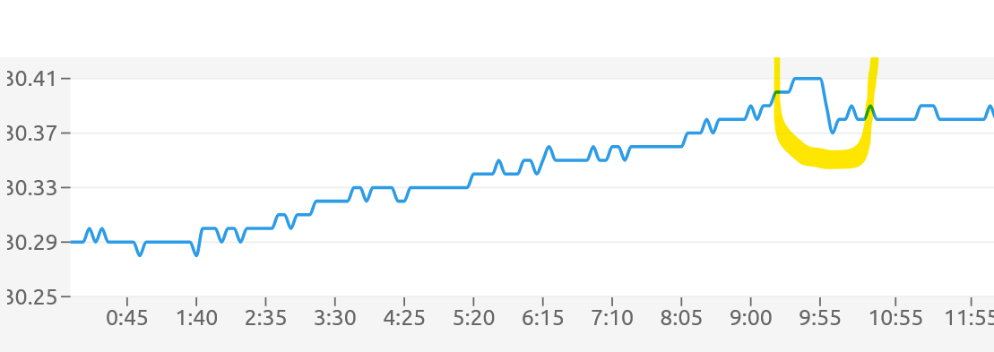
I posted this in the comments section yesterday. This is the graph from my weather station showing the pressure change due to the Tonga volcanic explosion on the 15th. The area in yellow denotes the change. The blast was likely the equivalent of a 10-megaton explosion, probably the loudest event since a 19th-century volcanic blast in Indonesia.
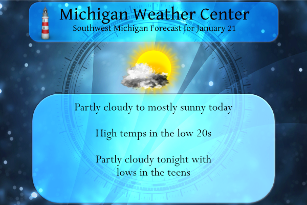
Skies will be partly cloudy inland, away from Lake Michigan today. A snow band is expected to affect areas north of Muskegon from Whitehall north through Ludington. By evening some local accumulations of around an inch will be possible. Highs today will generally be in the lower to middle 20s. Winds will be from the south at 5 to 15 mph.
Still not seeing any huge synoptic events in the near future as we have been under the influence to dry Arctic air with high pressure blocking any meaningful snowfall. My brother in Tennesee is reporting more snow there than we have had in the past two weeks – they have had eight inches during that timeframe. They moved down there to escape the snow and cold…
Forecast Discussion
-- Fairly sunny except for lake effect snow Muskegon and north --

It`s not entirely on radar currently as the boundary layer
convection is capped at 5000 feet, but there is a stationary band
of lake- effect snow from just offshore Ludington down to the
middle of southern Lake Michigan. Surface winds from airports
surrounding the lake clearly show a land breeze. And GOES-East
satellite (recommend Nighttime Microphysics RGB or Ch 14 Longwave
IR) shows some fascinating cloud-top divergence and evaporation as
mass at the top of the boundary layer emanates from the lake
effect convection, completing the upper half of the land breeze
circulation.

At the surface a synoptic high is centered over Lower Michigan this
morning. As the high moves east this afternoon, winds from the south-
southwest increase and move the lake effect snow band toward the
West Michigan shore. There is consensus among the HREF members of
the band affecting Muskegon through Ludington this afternoon, with a
chance of western Ottawa, Newaygo, and Lake counties also catching
some light snow. But given the shallow nature of this lake effect
convection and how the band will become increasingly sheared and
diffuse as it approaches the shore, the chance of significant
impacts to travel conditions seems low.

On the other side of today`s forecast challenge, to the southeast of
Grand Haven and Big Rapids, we are going increasingly sunny through
the day. It can be an occupational hazard to go optimistic with sun
in January when we are socked in with clouds early in the morning,
but there are some reasonably large holes in the clouds opening up
on satellite, and some of the clouds are already thin enough to see
the moon through. Weak subsidence due to the high/ridging today
should continue to erode the cloud cover, while increasing south
winds will make an attempt to bring that drier and cloud-free air in
northern Indiana/Ohio our way.

-- Chances of snow into early next week --

A quick-moving clipper passes through Saturday morning. Models
have ticked up a bit with QPF/snow amounts northwest of Grand
Rapids due to lake enhancement, and impacts to travel conditions
affecting US-31 and US-131 from a quick 1 to 3 inches of snow are
probable at this point. Cold air and cyclonic flow should keep at
least light lake effect snow going Saturday night.

An embedded shortwave rounding the base of the synoptic trough
may give southwest Michigan a quick shot of light accumulations
early Sunday morning.

Ensembles are pointing to another clipper providing much of the area
with light to moderate snow accumulations and possible travel
impacts on Monday.

Ensembles continue to give us fairly high confidence of another shot
of cold air passing through on Tuesday and Wednesday.
Who likes a good parade? Get ready for a parade of clippers! Incredible!
Bring it!
http://wxcaster.com/gis-gfs-snow-overlays.php?STATIONID=GRR
Placed a youtube video of a Meat Loaf concert at the end of the comments section
Thanks MV. The guitarist looked familiar to me, but I didn’t know who he was until the end credits. It’s Bruce Kulick – the guitarist for KISS from the mid 80s to the mid 90s.
Wow up to 7* degrees out in my hood will we even hit 10 15 degrees today the sun is nice though but dont let it fool its bitter cold outside…Loving this below average January we are in ..No warm air in sight….InDY
New commenter here: You all down in Grand Rapids must be having a much different winter than me. I am about an hour NE of GR. Although this past month has been nice and cold, we have barely any snow. We got about 6″ around the new year and nothing since and not much prior. We still have 2″ of that on the ground since it has been cold. The farmers around me are starting to get worried about a repeat of our dry spring last year.
Nope sounds about right. You just have some fervent snow commentators on here. Don’t mind them.
Welcome, Jesse!
Hey Jesse, yes Kent county and specifically Grand Rapids have been hammered with snow! In fact a couple weeks ago they set daily records and had over 12 inches of snow over a 2 day period! It was incredible and still plenty of snow on the ground!
Welcome Jesse, It would be kind of nice if you could give us your approximate location. As there are just spotty reports from areas between Grand Rapids and the tri city area.
Slim
Yah, that’s why I enjoy this blog. The reports are a bit better than the reports from the East side of the state. I live just NW of Crystal lake in Montcalm county. We don’t get much lake effect so we rely on storms to bring us our snow. I love storms (both winter and summer), but the past few years seem to have been relatively mild on that front.
Welcome Jesse! Had a low of 17 this morning and it’s become a beautiful day here. Lots of warm sunshine and no wind. Just returned from taking the dog for a walk. Quite a few neighbors were out doing the same thing. We have very little snow left here. I’ve only used the shovel once this season so far.
We play a game with song titles and I picked Anything for love but I won’t do that just a week or so ago. Rock on Meatloaf!!!
Shivering snowmans 5 degrees out in my hood ….Our very cold January continues..Incredible…InDY
No change is in sight, so enjoy winter!
We are still above normal for snowfall this month and now more is on the way! Incredible!
What a winter! The cold just keeps pummeling us and now accumulating snow is in the forecast! One clipper after another is on the way! Cold and SNOW rocks! I love it!
The overnight low here at my house so far is +3 the official overnight low so far is +7. Once again just a trace of snow fell yesterday here. There was snow to the SW of here as some cars had a lot of snow on them on I 196. There is now just 2.0″ of snow on the ground here. For January the snow fall remains 19.0″ and for the season it still is 38.8″ At this time it is partly cloudy and 3 here.
Slim
Welcome to day 15 of no measurable snow. This is really becoming a big snow drought in what is supposed to be the heart of winter.
R.I.P. Meatloaf – he passed at the age of 74
Sorry to hear that.
Slim
Bat Out of Hell (the 1st one) is an incredible album. My bro and I were just talking about him the other. We remember watching SNL when we were very young when Meat Loaf was the musical guest and the great Christopher Lee was the host. When Lee introduced him, Lee said, “Ladies and gentleman, I would like you to meet……Loaf. Uh, I beg your pardon? (as he was looking at the producer, presumably) Oh, I’m sorry. Yes, of course. Ladies and gentleman, Meat Loaf!” The pause between meet and Loaf for comedic effect was so funny. Found the audio.… Read more »
Thanks for the link
Slim
Awesome performer!