Not much snow here yesterday. We picked up .3 of an inch which brings us to 10.2 inches for the month and 23.3 inches for the season. We only need 17 inches more to beat last year’s total. Yesterday’s high temp of 42.5° occurred after 2 am, the low was 17°. We currently have 16° at 6 am.
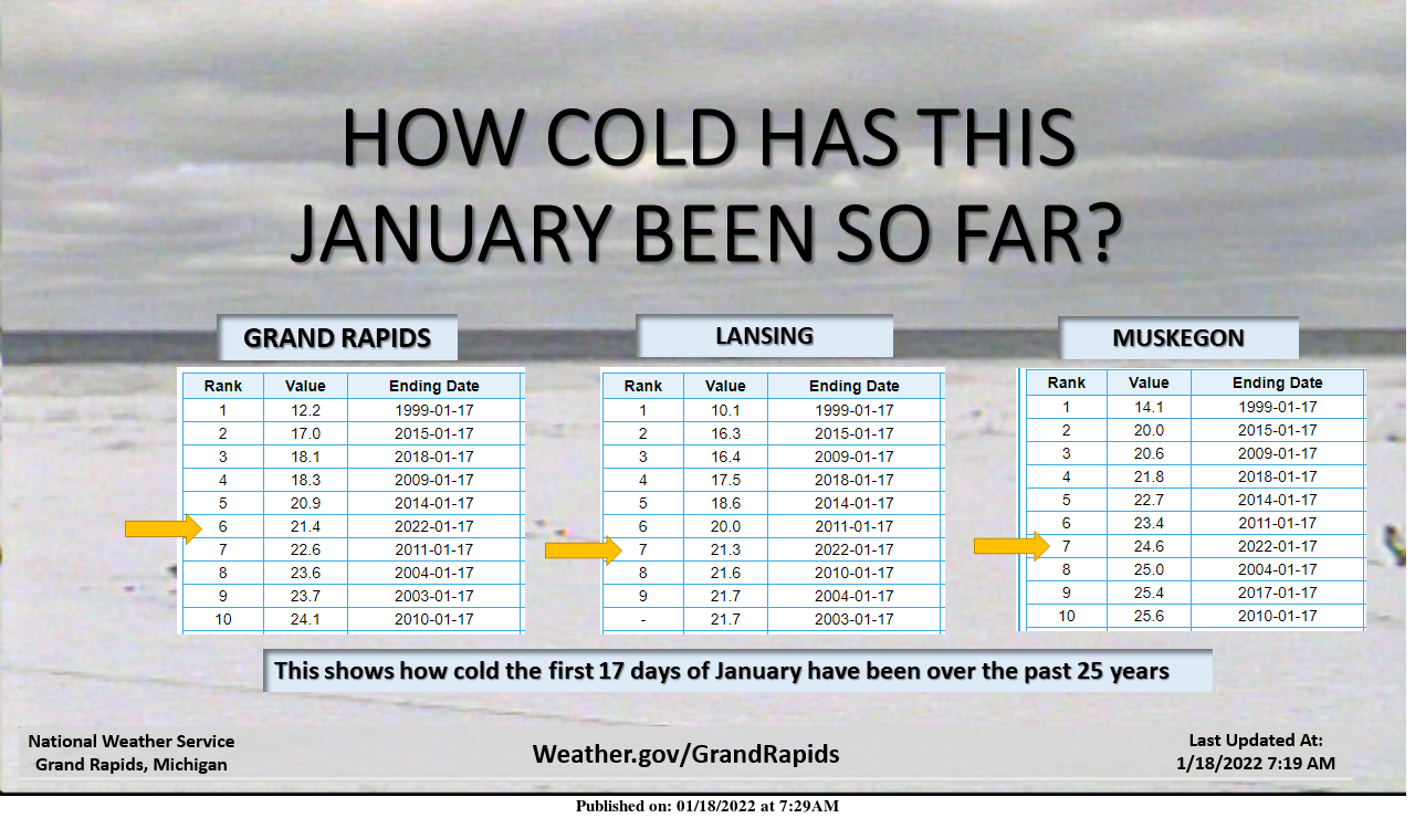
We have had a chilly month thus far ranking 6th and 7th coldest month
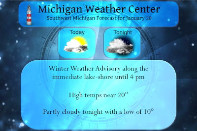
Temperatures will remain colder than normal and lake-effect snow showers will waver around the Lake Michigan shoreline. Slick roads can be expected in some locations. Typical of lake-effect snow, accumulations will be variable from place to place but isolated totals of several inches are possible by tonight. With a few exceptions, little if any snow is expected farther east across much of the Lower Peninsula.
...WINTER WEATHER ADVISORY REMAINS IN EFFECT UNTIL 4 PM EST THIS
AFTERNOON...

* WHAT...Snow. Additional snow accumulations of up to 4 inches.

* WHERE...Mason, Oceana, Ottawa, Allegan, Van Buren and Muskegon
  counties, near the lake shore only, for all of these counties.

* WHEN...Until 4 PM EST Thursday.
Forecast Discussion
- We Continue our Winter Weather Advisory Today

As we had been thinking the land breeze has pushed our lake snow
band off shore early this morning. Once the sun comes up the land
breeze will not be as strong so that will allow the north/south
band of snow to move back on shore. All of our Hi-Res models
continue show this happening. They also continue to show good lift
in, centered in the DGZ through the day today. Inversion heights
are not all the high, in the 6000 ft to 8000 ft range but that is
more than enough to get heavy snow showers. Today is also when we
are in the deepest and coldest air of this event so that helps the
cause for the snow showers too.

I will admit it`s not to often we see 6" plus snowfalls in 12
hours or less with lake effect snow showers when a 1040 mb high
is moving into the area, as is true today. Typically this results
in a shallow inversion heights (below 5000 ft). However, today,
with the upper trough moving through, the inversion heights are
high enough, even so. Our max snowfall is in the 3 to 5" range.
Again this will be very close to the lake shore only.

It looks like the area close the shore will get the most snow from
this event, as we have been forecasting. It does not look like
this snow band gets to far inland through. Any location more than
5 or so miles east of US-31 will see little or no snow today. In
fact inland today I would think there should be a fair amount of
sunshine. Our IR satellite loops show clouds breaking up inland of
US-131, near and south of I-96. I would expect this partial clearing
will work it`s way farther north to near US-10 by midday. That
would be due to the land/lake breeze circulation causing sinking
air over central Michigan due the rising air over both Lake Huron
and Michigan.


- Snow ends and skies clear tonight

Tonight the surface high moves across Michigan. The surface high
does split as it tries to cross Michigan tonight, due to the lake
convergence circulation continuing. None the less, surface winds
become very divergent after sunset as the center of circulation
after midnight will be near Cadillac. This will once again push
our lake snow band off shore but this time it will get to mid lake
overnight. That will end the snow showers near the lakes shore
before midnight. It should also allow temperatures inland to fall
to near zero in many locations due to light winds, nearly clear
skies and dry air and snow cover near and west of US-131 and from
I-96 north. Still all areas will get very cold tonight.

- Surface High Rules Friday

The center of the surface high should be over Lake Ontario by mid
afternoon Friday. This will put all of lower Michigan in southerly
winds. That will also allow the lake snow band (it is still cold
enough of that band to stay together) to try to come back on
shore. Typically this comes on shore north of Muskegon and that is
what we are thinking for Friday. However, it will be not much more
than flurries when it does so in the mid to late afternoon.

For the most part Friday will feature a fair amount of sunshine
but it will stay cold as we are still in the cold air yet.

- Two systems with snow over the weekend

We have two systems to deal with this weekend. Likely the first
one will bring all areas of our CWA at least some snow Saturday
afternoon into Saturday evening. This is jet entrance region lift
event and those are very good at producing at least some snow for
us. Actually we have a coupled jet feature with this system but it
will be a quick mover. Most of the CWA will see between an half
inch and inch from this system. Locations west of US-131 will have
some brief lake enhancement so maybe 2-3 inches there.

What is driving that through is the now forecast 170 kt jet core
diving south over Manitoba Saturday morning. As that rounds the
base of the upper trough Sunday we get a weak surface low that
tracks just south of Michigan. There is some question to just how
far south this system goes so if the GFS is correct most of our
CWA will see a few inches of snow. If the ECMWF is correct most of
the snow will be south of I-94. We have low chance pops for Sunday
since the ECMWF typically does better with these systems. However
in this case the ECMWF and GFS have been all over the place from
run to run as to just where this system is. Thus the chance pops
make total sense at this point.


- Next widespread snow late Monday into Tuesday

Our next best chance for a widespread 1 to 3 inch snowfall across
the CWA is the system late Monday into Tuesday. The Canadian, GFS
and ECMWF have been featuring this system for nearly a week now in
one form or the other. This is a wave that develops on the front
to our south as the tail of the 170 knot jet exits the Great
Lakes. What helps through is we also have a 130 knot sub-tropical
jet that comes over it Tuesday morning. This storm could be a
bigger storm than we are now forecasting if there is some sort of
phasing of the northern and southern stream. Snow lovers have
something to hope for!

- Much colder midweek then warming into the weekend

So the jet core drives down the coldest air of the season behind
it for the middle of next week. The ECMWF is colder than the GFS
and given the set-up, I am going with the ECMWF. We could have our
first widespread overnight lows below zero Wednesday and Thursday
morning,

Once that system gets through we seem to get shortwave ridging
late in the week ahead of the next Pacific system tracking along
in the upper low. This would create deep southerly flow ahead of
it and may lead to a rain/snow event the following weekend. We
will have to watch this as we will have a considerably more river
ice by then. Rain and warming southerly winds could break up some
of the ice causing ice jams.
Boy its cold outside I have a temperature of 15* degrees no worries on any snow melt soon ..InDY
No snow melt but plenty of accumulating snow will be rocking soon!
BreakingWeatherNews>>>>the latest CPC for GGR shows below normal temps well into Feb and then normal temps with above normal precip for the entire month of February = tons of cold and snow chances! It is going to be a wild ride! Get ready now!
Incredible…..InDY
The snow events are looking very promising! Get your snowblower tuned up and ready to go! I love it!
http://wxcaster.com/gis-gfs-snow-overlays.php?STATIONID=GRR
Let it snow let it snow let it snow ….InDY
BREAKING NEWS>>>>>> NO JANUARY THAW THANK YOU!!!! InDY
On the contrary, it may even get colder and snowier! Who would have thogut?
Keep the facts rolling Indy! Outstanding work!
Great news – we have about 60 days of winter left! Wow!
In 60 days, we will probably be in the 40’s or maybe 50’s. I wouldn’t call that winter.
Others have posted the pressure drop from the Tonga explosion – here is the graph from my weather station (area in yellow):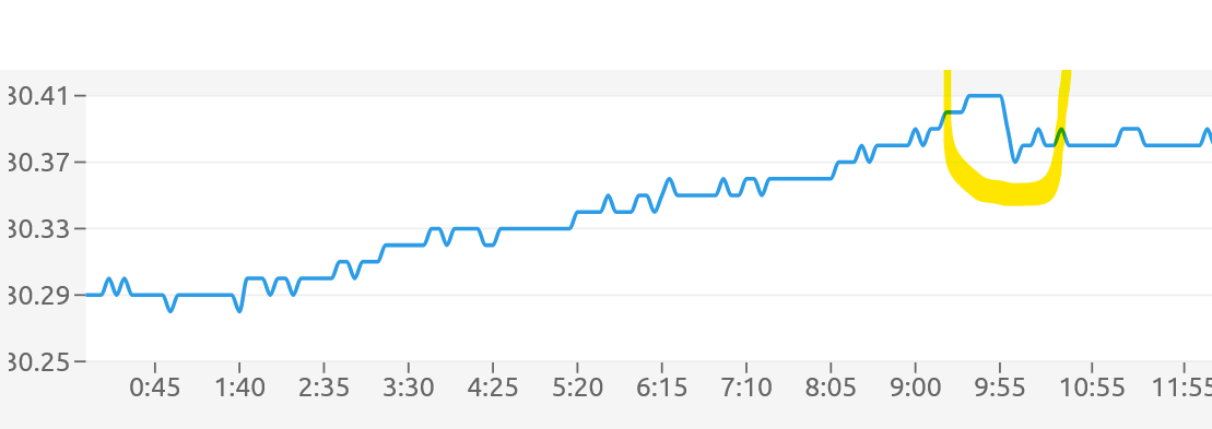
Wow that’s really cool!
Wow is right! It’s amazing that we can feel the effect from something on the other side of the planet.
The just released monthly outlook from CPC shows most of Lower Michigan in warmer than average temps for February. And says pretty much all of Michigan will have a warmer than average Feb-Apr period. Great news on what looks to be another short winter!
Wrong again! That is no surprise!
Welcome to day 14 without any measurable snow. GR is now several inches below average on the season. Really soon now the average temps will begin rising into spring. I love it!
We are finally about 1 month out from the December solstice and have gained just over a half hour of daylight. Of course temperatures won’t cooperate for another month or so at least. It is looking very cold for the rest of the month. This may be a top 10 coldest January for GR.
Who knew?
I noticed this morning that it was not completely dark out when I dropped the kids off at school. The days are getting longer. 🙂
Just trace amounts of new snow fall here at my house. The snow pack is now down to 2.3″ of old dirty snow. The overnight low here was 15 and at this time it is cloudy with a few flurries and 17.
Slim
Check this out and get ready now!
http://wxcaster.com/gis-gfs-snow-overlays.php?STATIONID=GRR
Wow, what a winter! The cold and snow just keeps coming! facts!
1. We are well above snowfall normal in GR for January!
2. We well below normal for January temps!
3. A lot of cold is in the forecast!
4. Plenty of snow chances and clippers heading our way starting this weekend!
5. Outdoor winter sports are excellent right now!
6. Snow on the ground for weeks on end!
7. Winter in West MI is incredible!
8. Rock n roll will never die!
All of this despite the constant warm weather snowless hype! Incredible!