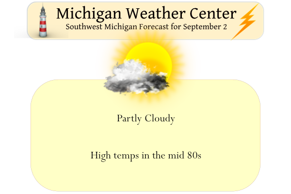
Today we will see temps once again in the 80s with a slightly humid airmass in place. Sunrise today was 7:10 and sunset will be 8:18 pm. Yesterday’s high was 85° and the low was 59° in Otsego.
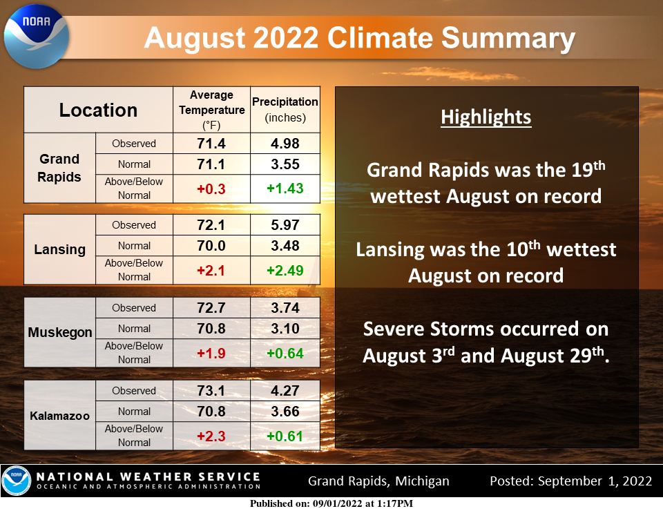
Here is the August Climate summary. Even given the cold spell this August the average temperature for the month was above normal at all climate sites. Precipitation was above normal as well. Lansing was the 10th, wettest August on record and Grand Rapids was the 19th wettest on record.
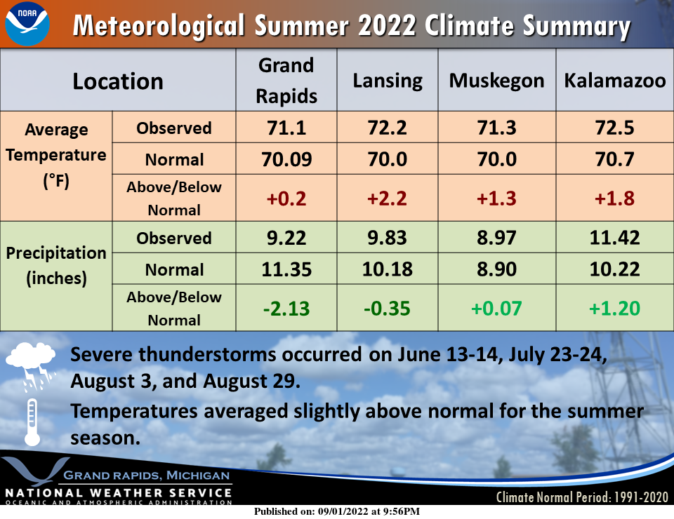
The meteorological summer season (June, July, and August) turned out slightly warmer than normal with periods of drought.
Forecast Discussion
-- Chance for rain Saturday and Sunday --

The overall scenario of the forecast for Saturday and Sunday remains
close to previous thinking. That is that there will be a few showers
and storms around, but these days will not be washouts by any means.

We are still expected to remain dry for just about all of the area
and time today. Some of the models are showing maybe a sprinkle or
very light shower could pop up with just enough moisture/instability
during peak heating today ahead of a weak short wave coming in. The
lack of good moisture in place will keep any sprinkles/light showers
isolated at best.

We will see the continued NW flow aloft over the area push a cold
front into the northern section of the area on Saturday. This added
focus and additional moisture pooling along the front will help to
increase the rain chances closer to the front. Upper support will
offer a little bit of support with lower heights overhead. However,
there are no definitive organized short waves forecast to move
through on Saturday, although weak ones may be present.

Thunder will remain possible on Saturday, out ahead of the front.
There does look to be some sunshine as you get further away from the
front. This will lead to at least some destabilization of the
atmosphere. Models show that at least a few hundred J/kg of CAPE
will be around, with the potential of over 1,000 with temps in the
80s and dew points in the mid-upper 60s. The severe threat looks
significantly limited still by a lack of really any deep layer
effective shear, which will should be under 15 knots. Some small
hail or weak microbursts will be possible.

The convection should tend to diminish toward/after sunset Saturday
evening as diurnal heating is lost. The chance for rain will not
completely go away during the night time hours as there is a chance
that a short wave could drop down through the area Saturday night,
and touch off a shower or storm.

A few showers and storms will remain possible on Sunday, and will
likely be mainly confined to the southern half of the area south of
I-96. The cold front will make its way south of the area, sweeping
the better moisture pooling out of the area. We will see potential
additional short wave activity drop through the area, which will
help keep the chance in. Much of the area much of the time will
remain dry on Sunday.

-- Low confidence forecast continues much of next week --

We wish we could say that the models are developing a consensus and
good run to run continuity with the pattern for next week. We really
can`t though as different iterations and ways the pattern evolves
remains quite uncertain. Upper lows are just difficult to pin down.

The large scale pattern continues to show the upper ridge and heat
dome remaining in place to our west, and trying to nudge this way.
However, we continue to see the NW flow bring weak waves over the
state. How these waves dive SE, and then how the upper low wobbles
with all of it`s small features is what is causing the great deal of
uncertainty.

One could really say that there is a legit chance of rain each day.
All it would take is for a short wave around the upper low to rotate
into the area to bring the chance of rain. Where the upper low
wobbles is where the rain chances will be. If the upper low were to
stay a little further away, then drier conditions would be more
dominate. Without run to run continuity, there is not really
anything to hang your hat on for details at this time.
It looks like GR had a normal temp summer and next week looks nice and normal also! No heat waves in sight! What a summer!
The recent storms back on the 29th really racked up our storm reports for the year. This is the 4th quietest year for Michigan for severe weather since 2000 in terms of storm reports. The quietest by far was 2009 then 2017 and following that 2016. We stand at 258 reports currently in Michigan which puts us in 4th position.
Well once again I’m back home recovering. This time it’s not a dog attack is a car accident. I can’t seem to catch a break lately. I had the green light and someone turned left in front of me as I was doing 50mph and I hit the side of there car, slid sideways and came to a rest right on the corner near the curb. A bunch of people came to my car to make sure I was OK. Apparently the driver was driving reckless shortly before the accident occurred according to one person. That person saw the accident… Read more »
Glad you are okay. There are so many careless and reckless drivers on the roads, I especially notice when I’m biking
Hope you are doing OK and it will be hard to find a replacement car. Good luck!
Slim
gez – hope you feel better soon. I had a person t-bone me back in the 70s – they run a red light and hit me hard enough to flip my car, a nice Plymouth Duster. I didn’t break any bones but I was digging glass shards out of me for a week. Back then you could get a new car for around 5 grand…
My Summer recap… No Heat warnings no heat waves and hardly any humidity lots of rain in August easy-going compared to some Summers past .. I believe in my hood only 5 90 degree days … Well lets get ready for a wild wild Winter … INDY
With the warming climate, more and more people are moving to Michigan to escape the heat/fires/drought. It’s been all over the local papers, journals, and internet reports. I’m sure this beautiful summer only strengthened that trend.
We have some of the best weather in the country from May to Mid October. And I don’t mind a few cooler months as well. February and March are really the only months you want to escape Michigan.
Yea I agree with that. I think temperature-wise we are a really comfortable state. However we do get really gloomy during the cold season… that’s the main negative for me
Agree. Although the further away from Lake Michigan, the less gloomy it gets.
Compared to most of the United States out side of Alaska and the pacific northwest Michigan is one of the cloudiest places from mid October to late January. In Michigan Detroit and SE Michigan have the most sunshine. Detroit leads the way with around 180 days on the cloudy side Grand Rapids with around 160 and Sault Ste Marie with 156 are the least sunny. I am sure Houghton is also one of the cloudier locations.
https://www.currentresults.com/Weather/Michigan/annual-days-of-sunshine.php
Slim
I think over the past 100 years we average (in GR) about double the amount of snowfall. Likely due to the warming lake and higher amounts of LE snow. So I’d imagine it has also gotten cloudier over the past century too from Nov-Jan.
Yep, Lake Michigan is beautiful but you sure pay for it with snowfall and clouds in the wintertime!
It looks like at least Lansing, Kalamazoo, Flint, and Detroit all had top 20 or top 30 warmest summers ever recorded.
And probably one of the more sunnier summers ever recorded as well!
It definitely has been very sunny around here.
Not all locations keep a record of the percent of daily sunshine. At Grand Rapids the reported sunniest meteorological summer was 78% in 2006. The report for this past summer was 61%. I am not sure how true it is but I have seen reports that Grand Rapids is the only location that keeps the daily percent of possible sunshine.
Slim
The official H/L at Grand Rapids yesterday was 84/57 there have been many very nice days this warm season. There was no rain fall and the sun was out 91% of the time. For today the average H/L is down to 78/58 the record high of 98 was set way back in 1915 and the record low of a chilly 37 was set in 1946. The overnight low both here in MBY and at GRR was 66. Today should be the warmest day in the next week or so but that said next week still looks to be very nice… Read more »
I don’t think any of this data should surprise anyone. I’m happy we live in the upper midwest. So many other areas of the country had a brutally hot summer – especially out west.
A couple of items that are not in the summery is that at Grand Rapids that there was 61% of possible sunshine (many locations do not report the percent of sunshine) and at Grand Rapids the average HL was 81.6/60.7. Bottom line is that this past summer was a very nice summer in our area.
Slim