An exciting evening was in store last night as storms moved through many areas in SW Michigan. Tornado warnings were issued for Kent, Ionia and Eaton counties, however no tornadoes have been confirmed at this time. The NWS will be out this morning to inspect the areas for confirmation. There are multiple reports of building damage in Eaton and Kent counties. In downtown Grand Rapids, there was a report of 11 vehicles that had their windows blown out in a hospital parking lot.
Grand Rapids firefighters reported that significant damage occurred in the Belknap area, south of Fairbanks Street NE. They responded to a rescue on Fairview Avenue NE after a tree fell on a house. Firefighters evacuated a Northeast Grand Rapids apartment building after strong winds tore the roof off the structure and caused significant damage in the same neighborhood.
Witnesses also reported that partial roofs were torn off one or more houses. Firefighters were dealing with live downed wires in some areas.
In the Ada area, firefighters reported they were having trouble reaching a house on Dogwood Avenue NE where a tree fell on a house. Firefighters said Conservation Street NE was blocked by downed trees.
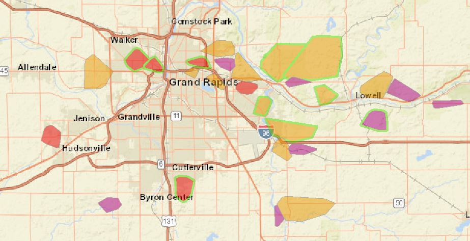
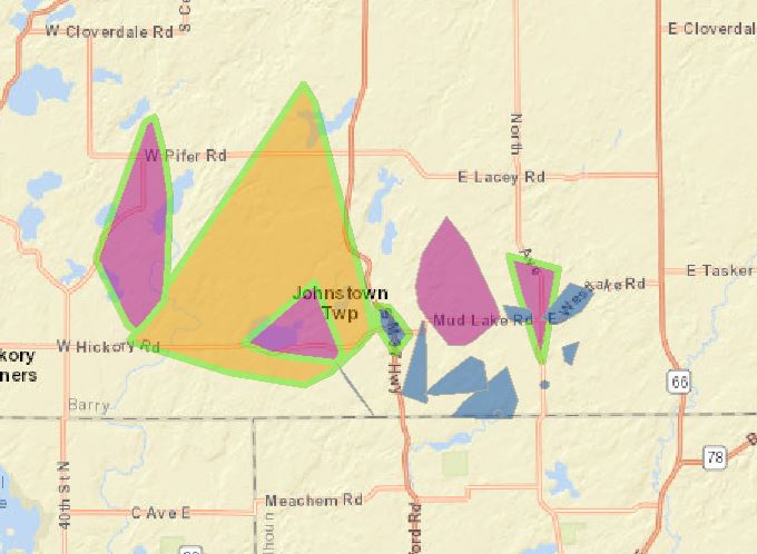
Below are the current power outages as of 7am this morning many for Barry and Kent counties. There are currently 563 reported outages affecting around 28,000 people.
Seems it has been awhile since were have had severe weather over a large area, Mr. Negatives interest must have been peeked as storms moved near his area in Ada.
We had some downpours with lightning and a bit of thunder in Otsego – our 24 hour rainfall total at 7am was .95 of an inch.
Today will be cooler than yesterday – as the clouds hang around. Rains will end this morning then return once again late tonight with a Canadian system…
My my, hey hey, rock n roll will never die and Winter Rocks! I can hardly wait!
Where is our update on how many days in a row above/below average we are at? After several double digit above average days, even today is running above as well.
Facts 7 out of the last 8 months GR has seen below normal temps! We are firmly entrenched in a below normal temp pattern! Facts matter!
Who said anything about the past months? I’m talking about your daily updates on above/below average. You seem to be slipping this week.
Yep…”my night” for at least another decade. The news makes it appear as though Ada is ruined. Granted, there are a significant number of trees down, but the trees are specifically situated on two roads. Both roads are considered “deep woods”, so…plenty of material to work with. The damage is one mile North of my driveway. A stormy night with sirens?…paradise.
Hope you enjoyed it! We took cover in our basement bathroom.
What do you think are chances are for another round tonight? I just wondered we have been so cloudy up until now it it will keep those storms away?
pretty good chance with a low pressure center heading our way – the NWS has a couple of their servers down at this time so the point forecasts on our main page aren’t working so I can’t pull in the data- you can check that and click on the city of your choice for the forecast for tomorrow when it becomes available
Thanks MV!!!
Dying line of storms coming through early morning tomorrow lwe don’t have the heat like yesterday to support any good storms tonight wih a cold front coming through ..I’m thinking some rain late tonight early tomorrow …INDY
That’s what I was wondering… it just feels so much cooler than yesterday.
here are the totals for Kent Co for September MI-KN-7 East Grand Rapids 2.21 MI-KN-8 Grand Rapids 1.62 MI-KN-11 Lowell 1.4 ESE 1.83 MI-KN-14 Grandville 1.3 WSW 0.68 MI-KN-16 Grand Rapids 2.5 ENE 0.25 MI-KN-17 Alto 4.5 SW 1.81 MI-KN-32 Grand Rapids 2.9 NW 1.68 MI-KN-33 Grand Rapids 3.0 NW 1.43 MI-KN-43 Caledonia 4.4 WNW 1.77 MI-KN-48 Kentwood 1.6 WSW 0.25 MI-KN-53 Ada 1.8 W 0.33 0.33 MI-KN-60 Comstock Park 3.7 NNE 1.44 MI-KN-65 Belmont 1.0 WNW 1.50 MI-KN-68 Kentwood 1.8 SSE 0.43 MI-KN-77 Comstock Park 1.0 NNW 1.19 MI-KN-78 Cedar Springs 2.8 SSW 1.18 MI-KN-86 Grand Rapids 5.5 SSE… Read more »
here are the rain totals for September thus far for Allegan Co – mine is the last on the list
MI-AN-1 Wayland 2.0 W 2.07
MI-AN-4 Fennville 0.8 W 1.20
MI-AN-11 Hopkins 0.6 NNE 1.81
MI-AN-16 Holland 4.1 WSW 1.82
MI-AN-19 Saugatuck 0.6 E 0.55
MI-AN-20 Holland 5.3 WSW 0.64
MI-AN-23 Saugatuck 5.0 ENE 1.49
MI-AN-25 Plainwell 0.5 WSW 0.84
MI-AN-27 Otsego 0.9 WNW 1.56
We ended up with 0.81” of needed rain, almost half the amount we’ve received in over 2 months. Top wind gust here was only 36mph, strongest part of the storm was off to our North. Lots of lightning to watch, but none of it was near our area. Looked ominous coming in though:
I know, nice placement of the watermark. That’s what you get with a free account. 🙁
Nice photo Barry. This is a view I don’t have, as we live in a forest over here 🙁
Nice photo. I took a few myself of same clouds.
Amazing Storm again last night in west Michigan we are safe out at thee YARDofBRICKS NE of GR I did 13 hour of tracking yesterday it’s been a long time since I have done that I had my gals at practice wife at work so I stayed back from going chasing I’m glad I did because the bad part of the storm was near here I’m going out to survey some of the damage this afternoon I’m thinking when it’s all said and done with from the NWS we will have 2 confirm Tornadoes that touchdown maybe 3 in northeast… Read more »
The lightning show was something last night. The storm that rolled through here just after midnight had some house shaker thunder in it!
Added note when a number of power outages are given that is the number of locations not the number of people without power. So each house and or building counts as one even it 10 people live in that building.
Slim
Wow what a wild storm last night! A lot of lightning very heavy rain and to the south of me a good amount of damage and downed trees. Along with a lot of power outages. Here at my house the power stayed on but just to my south it was dark and it looks like the power is still out in many areas of the GR metro area. Here at my house I recorded 1.05″ of rain
Slim