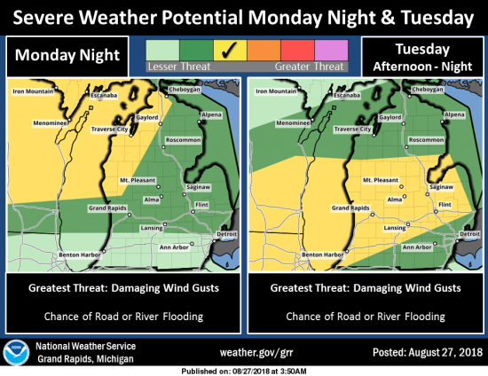
Wild night From Grand Rapids to the north. WOOD is reporting power outages from winds. A 66 mph gust was recorded at Muskegon, a 55 mph gust at Grand Haven and 53 mph south of Fremont. Consumers outage map can be found here.
As of 6:30am these are the reported outages:
- Ionia County: 982
- Kent County: 18,579
- Mecosta County: 884
- Montcalm County: 4,462
- Muskegon County: 5,283
- Newaygo County: 1,115
- Oceana County: 245
- Ottawa County: 2,032
Rainfall totals this morning are high around GR (these are 7am totals according to CoCoRaHS):
- Wyoming 2.11
- Grandville 2.08
- East GR 2.00
- Downtown GR 3.19
- Comstock Park 2.54
- Rockford 2.55
- Cedar Springs 2.60
- Muskegon 2.75
- Grant 2.85
South of Grand Rapids I am seeing no reports as it remained dry overnight. Moderate to heavy rain continues from GR to the north. Below is the 7:30am Radarscope image.
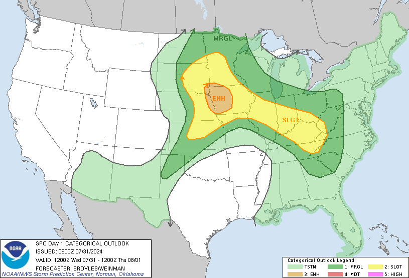
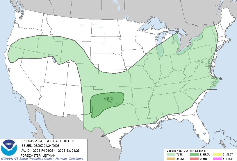
Below are the SPC outlooks for today and tomorrow: These will auto update.
[columns] [span6]
[/span6][span6]
[/span6][/columns]
From the NWS:
Rounds of showers and thunderstorms will continue over the next few days as very warm and humid air interacts with a stalled frontal boundary. The front will finally push through the area on Wednesday night, with dry weather following for the end of the week. Severe thunderstorms and heavy rainfall will be possible through Tuesday night..


Right now it is 81* with a heat index of 93* here.
It looks like no storms tonight. We had some thunder around 3 AM that I jumped out of bed. LOL It was so loud. Not used to hearing it.
Still no 90’s with this supposed heat wave! What a joke!
And the heat index only topped out at a cool and brisk 96 degrees. Refreshing?
And it is still hot out at this hour.
It was very HOT today. It was oppressive.
Back to back days with heat index over 90 degrees! Looks like we’ll go for 3 in a row tomorrow.
Yep, looks spot on.. Oh. and for you winter lovers.. Looks like a below normal snowfall type of winter. I can hear the whining already. Lol! https://www.youtube.com/watch?v=mjs-ez3yuuI&app=desktop
2 citys in Michigan ended up in the top 3 overall snowfall in the untied states! INDYDOG14!!
It was INCREDIBLE!
What a weak winter last year was for GR. If you don’t count the snows that melted within hours, we were well below average in GR in terms of useable snow. Horrible year for winter sports.
Ok Slim, since you are the stats guy, where is Grand Rapids for 2018 snowfall? Not the 2017-2018 winter, but just for the current calendar year.
Seasonal snowfall is measured based on Sept 2017 through May of 2018. Why in the World would you measure snowfall for 2018 so far? This coming winters snowfall begins next month! Calendar year snowfall is irrelevant so why are you even tracking this stat? Your mind works in a strange way!
Just throwing our some random facts like you do every day. I’m not allowed to do it once? I thought it was rather interesting stat to put things in perspective.
With the clouds rolling in again going to be hard to make 90* again in GR. Today ?? INDYDOG14!!
Heat index is already 90 at the airport so if you really want to feel what it’s like, head over there.
Yes interesting however totally irrelevant when discussing seasonal snowfall totals!
Well I read it recently on Bills blog, so I guess you should then be telling him how irrelevant it is.
Well said Barry! I miss the comments but, not these trolls on Bills Blog.
Barry it is true that seasonal snow fall amounts are measured from July 1 to June 30. Now for the answer to your question so far this year (2018) Grand Rapids has recorded 44.2″ of snow. The 30 year average for January to August is 48.2″ for the season last winter Grand Rapids reported 77.6″ the current 30 year average is 76.4″
Slim
Thanks for confirming Slim. Bill had talked about it recently, I just didn’t remember the exact numbers he had put.
ADA – 2.20 inches of rainfall overnight. One loud rumble at best, otherwise nothing more than an entertaining evening of watching “flashes” to the north. Thankful for the rain.
Latest GFS run gives us 90-95 degrees September 4th-6th!
Won’t happen!
Excessive heat watch already to our south for that time!
http://www.cpc.noaa.gov/products/predictions/threats/temp_probhazards_d8_14_contours.png
Too Funny!
The average highs are in the 70s, so that would be incredible.
We got wrecked out at thee YARDofBRICKS over night we do have power but no cable and internet best storm since 2008 I would say 57 mph wind gusts window rattling Thunder saw some Tornadoe vortex on radar shuuuuu.. on the fun side of things Marquette Michigan Gaylord Michigan last winter ranked number 2 and 3 city’s with the most snowfall in the untied states just behind Erie Pennsylvania as #1 .. More storms on the way have a good day .. INDYDOG14!
That is awesome INDY! Yes it was a great winter in the North country this past winter! I was skiing and snowmobiling constantly all winter. This was during the time Mookie and others were saying it was a mild winter with very little SNOW! INCREDIBLE!
Actual fact….GRis BELOW average for snowfall for 2018! Look it up.
Maybe in zland where it doesn’t snow lol!! Not sure what GR has to do with my post … INDYDOG14
Wasn’t replying to you. Replying to the rock guy/gal.
YARDOFBRICKS had above snowfall last winter .. INDY!!
I think the heat is getting to you! Stay hydrated today!
You are 100% wrong! Did you forget the snow we picked up in April? The GR snowfall for last season was a whopping 78 inches! The average snowfall is 74.9 inches! It was a great winter for outdoor winter sports! Mark it down!
I am talking for the calendar year 2018, not the 2017-2018 winter total. For the year we are BELOW average for snowfall.
We have had only one real heat wave this entire summer and this week sure will not qualify! Get ready for below normal temps starting on Wednesday! Bring it!
Well you are right about only one heat wave, and it has lasted the entire Summer! Third most uncomfortably hot and humid Summer in my lifetime.
haha One heat wave the entire summer. Sounds about right!
The few days around the 4th of July actually qualified as a heat wave, other than that not too bad of a summer!
Well the thunderstorm drought broke overnight. Here at my house I recorded 2.38” of rain over night. With several rounds of thunderstorms. Here this morning it is cloudy (dark to the north and less so to the south) and a temperature of 70°. Grand Rapids official high yesterday came in at 88° The mean for August is now at 74.0° that is a departure of +2.8° At this time that is good for the 10th warmest August of recorded history at Grand Rapids.
Slim
Wow! I had no idea about the winds and rain overnight. We didn’t get a drop here.
Another heat wave to start September!
http://www.cpc.noaa.gov/products/predictions/610day/610temp.new.gif
Good grief! Does it ever end???
Yes it will end. In September the average high drops from 78° on the 1st to 74 by the 15th and 67 by the 30th. So after mid September we will see more days that are cooler. And even above average will be cooler then it has been. There is no stopping the march of time fall and then winter are on their way.
Slim
Yes, but then you go way back to last year and it was even hotter at the end of September than it was all year, flirting with 100 degrees. Just seems like it’s been a very long stretch of very uncomfortable weather. Our fire pit has been used very little this year because no one wants to sit at a fire when it’s 80 degrees and humid at 9 o’clock in the evening.
Last September hit 96 degrees towards the end of the month. Last October saw multiple days in the 80’s. There were 60’s in November and December.
Big storms, heat advisories in southern Lower Michigan, heat index over 90 yesterday. The hot summer just keeps going.
The drought in Northern Kent County is over! Tons of rain! Will it hit 90 degrees today? It is going to very close!