One couldn’t ask for a nicer day than the one we had yesterday. We had a record of 61.7° here in Otsego under mostly sunny skies. Not often we can go out in December in a t-shirt. Normal temps for this time of the month is 32° so our departure from normal was nearly 30°.
Another noteworthy stat is yesterday was the 8th day in a row with no precipitation, the longest stretch since September of 2018. This should carry on through today and most of tomorrow when a soggy system moves in for the latter half of the weekend.
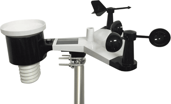
We have a new weather station which put up yesterday – this is a more complex system than I have had in the past – programing, assembly and installation took over three hours to get online. It is an Ambient Weather Osprey shown below. Along with the usual sensors it includes U.V. index and solar radiation outputs.
The output from the sensors allows me to program the readouts here on the site.
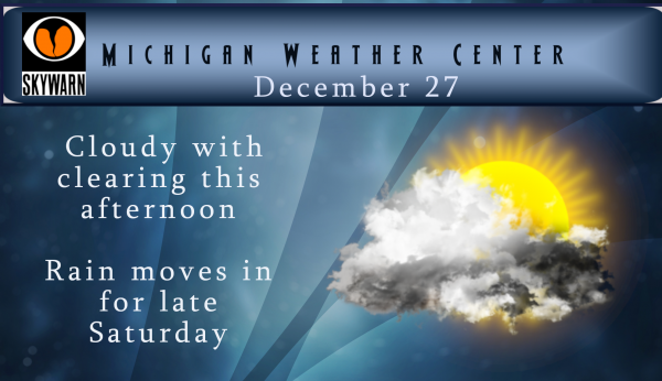
High temps today won’t be as pleasant as yesterday with readings near 40° with cloudy skies. We should see some clearing this afternoon. Our nice stretch of weather will come to an end late Saturday when rain moves in – Sunday through early Monday we could see over an inch of rain before it turns to snow Monday morning – the lake effect snow machine will kick in to ring in the New Year. New Years eve could bring hazardous travel conditions so keep that in mind should you be traveling going to any parties you might attend.


That is a really nice new weather station!!
We finally finished our fall cleanups today… Now we can concentrate on snowplowing, 95 days left on contacts…
WWA will be issued for Monday night and Tuesday! Kent county will be included! Wind, cold, snow, and slippery roads are all in the offering! Incredible!
Breaking news********Clearly the CPC is showing above normal snowfall with near to slightly above normal temps! This means plenty of system snows will be heading out way in January and beyond! Get ready now!
Not Breaking News….you said the same thing for October, November, and December, all of which have and will end up with well below normal snowfall. Who knows, maybe you get one right. Or maybe we end up with a Winter without much snow. Won’t know for a month or two.
Cool weather station, MV!
Wow the CPC is warmer all the way until late January now! Looks like any snow and cold will be short lived. I love short winters!
Short winters ROCK!! Just saw the CPC calling BS on any cool down!
GFS MODEL is showing some good snow here Monday night into Tuesday yes that’s the GFS MODLE in caps so some understand where it’s coming from …I’m thinking Winter Weather Advisory criteria snows Slim Rocky MV any thoughts?? INDY …
Possible watches Monday into Tuesday now? Stay tuned lots of new DATA coming in! INDY
Just another snowless well above average day to add to the streak. Today’s high temp of 48 is +16 over the average high of 32.
Currently 34* degrees cloudy out at thee YARDOFBRICKS NE of GR …Back to December stander love it …INDY
Nice new weather station!!
Slim, it was stated yesterday that last month we had a day that ended up 35 degrees below the daily average. Maybe I missed it, if so, what day was it? I don’t recall any day being that far below average.
The coldest day to average last month was November 12th with a departure of -21.6 the high of 24 was a departure of -25 for that day. For December the biggest departure so far is the 26th at +23.5° and the biggest negative departure is -14.3 on the 11th Some of the biggest departures here in Grand Rapids was in March of 2012 and on March 21st the departure was +36.6
Slim
Thanks Slim. I kind of thought that was made up.
Great so the cold in November was more extreme than the warmth in December! Thanks for the facts and 9 out of 12 months this year we had below normal temps! We are entrenched in cool pattern and winter is about ready to hammer us! I love it!
I think you read that wrong. Yesterday’s departure beat the average by 23.5 compared to the biggest departure in November of 21.6. Yesterday’s high of +29 also beats November’s coldest of -25. As for the pattern we’re in, it’s been back and forth for 6 months with 3 above and 3 below.
I am sure it will not stay this warm for all of January so yes it will turn colder and yes there will be snow with the lakes wide open and the fact that they should be warm there could be times of a lot of lake snows. But that said there still is not a clear hint that it will stay cold for the whole month while that could change at any time that is the best guess at this time. Here is a short write up from Paul Paskelok from his post today (December 27th) “COLDER IN THE… Read more »
Great info Slim thank you ….I like the sounds of that to ..INDY
Nice weather station MV.
Slim
Bring on the lake effect snow and wind!
Possible blizzard conditions Monday night into Tuesday now amazing …INDY
Like the post reads all good things come to a end interesting we will see if slim changes his thoughts on Seeing no real cold air or snow for the month of January ahead…Like I have been saying Winter weather advisory criteria weather coming Monday into Tuesday love it ..INDY!! Have a good Friday…
Rock on and keep the facts rolling!
At this time my guess is that January will be a up and down month. For any cold shots there is a lot of cold in Canada at this time but no clear sign if or when it will be pulled down. Any cold that comes in could mean a good bit of snow as the lakes are open and warm for this time of year. One thing to watch for is it to turn cold in February and stay that way well into spring. I could see it play out that way. But hey it is all just a… Read more »
Yes Slim we do ..When you heading to Florida? INDY
This year I am not going to Florida next year we are planing on going.
Slim
Great news winter weather fans! All signs point towards a major pattern change. This change will start next week and then really hit the following week! Get ready for a Rocking good time! Cold and snow will rule for weeks on end! Nothing better! Incredible!
Yup January 5th been my thought for 2 weeks now looking good ..And all signs are saying it could last well into March …INDY
Don’t worry there about 3 people on here that will never face that reality!
And we will here about yesterdays warm weather till April now lol….INDY
What an incredible pattern we are in! Record breaking high temps, way below average snow, and plenty of sun. Looks like a day or two cool down next week, then right back into the 40’s to melt it all away again.
Forget this warm weather! I am starting to like the sounds of this for next week!
From NWS, Return to winter Monday through Wednesday Colder air surges into the area Monday morning which remains in place into mid week. Precipitation will rapidly change from rain to snow Monday morning with accumulations likely. System snow is expecting on Monday associated with a deepening low across the Lake Superior region. Monday night into Tuesday night lake effect snow is expected in westerly flow off of Lake Michigan. The lake effect side of things looks impactful with deep moisture and delta T`s in the lower to middle teens. We are looking at accumulating snow by mid week for areas… Read more »
Like the sounds of that …INDY