I hope you all have your clocks set ahead this morning – as much as we may despise having the time change it must be done with minimal whining and groaning.
On a positive note, I am thinking we are experiencing the last gasp of winter after yesterday’s cold temps. We had a high yesterday of 21° and a low of 11° with 1.2 inches of snow. We are up to 4.6 inches for the month and 59 inches since November 1st. Driving around the Otsego/Plainwell area yesterday I found myself in areas of heavy snow from the bands of lake effect. We had 131 shut down for several hours northbound. This is notorious for slide-offs due to the wind and snow which blows across the flatlands which can cause visibility issues.
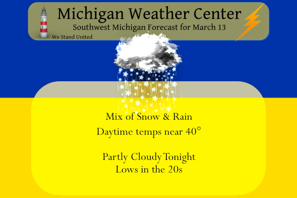
We have another shot of snow today mixing with rain as temps rise to near 40° then our warmup begins as the wind begins flowing from the south rather than the north. We will see temps warming into the fifties to near 60° beginning tomorrow.

Light snow will work through Southwest Lower Michigan this morning. Most areas will only see a dusting to around an inch of snow at most. A few areas along the lakeshore may see 2 inches of snow, especially from Grand Haven north up the lakeshore towards Ludington. Light snow will end midday with skies turning partly sunny this afternoon. It will be brisk today with southwest winds of 15-25 mph. Highs this afternoon will climb to the upper 30s to lower 40s.
Hazardous Weather Outlook
Some snow is expected this morning, with the heaviest amounts
along the lakeshore north of I-96 around 1 to 3 inches. The US 127
and I 94 corridor should receive around an inch.
Forecast Discussion
- Sunday Morning Clipper -

Snow is falling through Wisconsin as a clipper continues to move
towards Michigan. Models continue to speed up the progression of
the upper level trough that is driving this system. Expect snow
showers to begin before sunrise and continue through mid morning.
This clipper will be fairly short lived as it exits Lower Michigan
this afternoon. This system will be enhanced by warm southwesterly
flow across Lake Michigan.

 Still expecting a 1 to 3 inch snow event, this time aimed at the
favored southwest flow area north of Muskegon to Ludington. around
an inch is expected along the I -94 corridor with less than an
inch northeast of Grand Rapids.

- Milder weather through the upcoming week -

The clipper will lift out this evening and the warm southwesterly
flow will continue as a negatively tilted high allows for milder
and warmer weather to propagate into the area.
 Another sfc low tracks across Lower Michigan on Monday with the
bulk of the precip north of the forecast area per the ECMWF. The
GFS is still blossoming precip along the trailing cold front on
Tuesday morning but this seems unlikely.

Warmer and milder weather will dominate through mid week with the
end of the week seeing a deepening low lifting northeast from the
Southern Plains and could bring significant showers through Lower
Michigan Friday into Saturday. Will have to wait as this timeframe
gets closer to determine timing and strength.
Looking great the next 10 days!! No temps below freezing!! Hello Spring!!
https://weather.com/weather/tenday/l/b4ea0280869baa46799dc75eacef8904785ec43ad2f6fb098355fbc208a55e2c
Snow storm Friday into Saturday???. Ruut roo ..Stay tuned…InDzy
This time change is fantastic. It is still bright and sunny outside 😀
43 and sunny here. After a chilly start, it turned out to be a nice day.
It’s only March 13th but I officially declare winter is over! Hello spring!
Sounds good to me!!
It really is a beautiful day out. All the snow that came Friday night and last night has melted. My driveway is clear and dry thanks to the sun. Yesterday I picked up some of those solar lights that look like flowers. I have mine out in the sun charging and later they will light up. 🙂
Love those!!!
For those that thought yesterday was cold, this was the weather 8 years ago today. March 2014 was VERY cold.
https://m.youtube.com/watch?v=Goo2EdFmpj0
Yes winter 2013-2014 was crazy. I think that was the year we had “snow frost” in early spring.
It’s a winter I will never forget. That a textbook severe winter. I would be interested to know how many total hours the entire length of winter we spend under some sort of winter weather headline (whether it’s Wind Chill, Winter Storm Watch/Warning or advisory). Seems like it snowed every single day. As Rocky likes to say, the snow just keeps coming and coming. That was definitely the case that winter.
The AWSSI chart that was posted the other day (the start year is the winter of 1950/51) has the winter of 2013/14 as the most severe winter at Grand Rapids in the years 1950/50 to 2021/22.
Slim
I believe it. It was a historic winter.
MV I like your first sentence: The time change must be done with minimal whining and groaning. I just woke up a couple minutes ago and was complaining LOL
Wait a minute more snow outside…Is it still January???? Lol..InDzy
It definitely looks and feels like January! Incredible!
What? It is snowing again! GR could go over the 70 inch mark today! What a winter! Tons of snow and cold yet some are saying it was mild winter? Enjoy winter people, because it is the best season of the year and it may be winding down next week! The skiing conditions this weekend and virtually all season has been spectacular! Wow!
Yesterdays official high of 18 at Grand Rapids tied 1896 as the coldest maximum for any March 12th. At Lansing their high of 20 is now the 2nd coldest maximum of any March 12 and at Muskegon their official high of 24 was the 4th coldest maximum. This morning there is light snow falling and the ground is now covered here with just under a half inch of new snow with a temperature of 17.
Slim
Wow another cold record and yesterday was about 20 degrees below normal! Incredible!