We are at the halfway point of December 2023 and at this time the snowfall drought continues. There is a good chance of lake effect snow on Monday and some locations will receive a good snowfall. But the wind direction is not favorable for Grand Rapids. If GR gets less the less than an inch it the forecast we will still be on track for one of the lowest snowfall totals to start a winter season. At the current time GRR only has recorded 2.0” of snow fall.
Here is the summary for December at the halfway point of December at the major locations in SW Lower Michigan. Grand Rapids. The mean so far is 37.2 that is +4.8° the high for the month so far is 58 on the 9th and the low so far is 22 on the 13th there has been just 0.1” of snowfall that is -8.9” below where we should be at this time. There has been 0.85” of precipitation average is 1.24” All 15 days of December so far have been warmer than average. At Lansing the mean there is also 37.2 but because it was colder there in the past. So that 37.2 is -5.6 above average. The high so far this month is 59 on the 9th and the low so far 23 on the 13th there has been just a trace of snow fall at Lansing and that is -5.9” below average. There has been a total of 0.93” of precipitation 0.94” is average. At Muskegon the mean there so far is a very mild 40.3 that is +6.6 above average. The high for the month so far is 58 on the 9th and the low so far is a mild 28 on the 1st there has been a total of 2.0” of snowfall average as of this date is 9.8” there has been 0.79” of total precipitation 1.24 is average. At Holland the mean there is a mild 39.0° so far the highest high of 58 was on the 9th and the low so far is a very warm 30 on the 11th and 13th There has been a total of 1.0” of precipitation so far they do not report snowfall amounts at Holland.
The official H/L yesterday at Grand Rapids was 53/32 there was no rain or snowfall. The sun was out 80% of the possible time. Yesterday was a very warm mid December day across SW Michigan. While no records were set that 53 was the 5th warmest December 15th at Grand Rapids. The high of 55 at Lansing was the 4th warmest. The high of 52 at Muskegon was the 3rd warmest and the high of 52 at Holland was the 6th warmest. For today the average H/L is 36/25 the record high of 63 was set in 2021 the record low of -2 was set in 1901 and 1989. The wettest was 0.97” in 1921 the most snowfall of 5.7” was in 1911 the most on the ground was 13” in 1970. Last year the H/L was 33/23 and there was 2.7” of snowfall.
Some weather history for today in SW Lower Michigan
1984: Mild weather prevails with record highs of 61 degrees at Lansing and Grand Rapids.
1989: Persistent cold weather continues during of the coldest Decembers on record in Lower Michigan. A record low of 2 below zero is recorded at Grand Rapids while another 5 inches of snow piles up at Muskegon, contributing to a monthly total of 77 inches there.
AREA FORECAST DISCUSSION
NATIONAL WEATHER SERVICE GRAND RAPIDS MI
337 AM EST SAT DEC 16 2023
LATEST UPDATE...
SHORT TERM/LONG TERM/MARINE
SHORT TERM
(TODAY THROUGH SUNDAY)
ISSUED AT 330 AM EST SAT DEC 16 2023
- DRY AND WINDY TODAY
ONE MORE DAY WILL BE DOMINATED BY HIGH PRESSURE AS WARM DAYTIME
TEMPERATURES WILL ALLOW FOR GUSTY SOUTHERLY WINDS UPWARDS OF 20
MPH THIS AFTERNOON AND EVENING. ANY LIGHT SHOWERS AND THE
CORRESPONDING CLOUDS SHOULD REMAIN NORTH OF THE SOUTHERN LOWER
TODAY AS THE REGION SHOULD REMAIN STABLE WITH THE UPPER LEVEL HIGH
STIFLING ANY CONVECTION. HOWEVER, THERE COULD BE ENOUGH LOW LEVEL
MOISTURE TO ALLOW FOR A SPRINKLE OR TWO THIS AFTERNOON SO HAVE A
SLIGHT CHANCE POPS.
THE NEGATIVELY TILTED RIDGE OVER THE GREAT LAKES WILL BE PUSHED
EASTWARD BY A DEEPENING UPPER LEVEL LOW MOVING THROUGH THE
CENTRAL UNITED STATES. AS THE HIGH TREKS EASTWARD CLOUDS WILL
CONTINUE TO OVERSPREAD THE AREA THIS AFTERNOON AND EVENING.
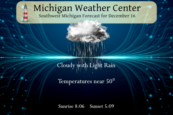
- CLOUDY WITH CHANCE OF SHOWERS SUNDAY
THE UPPER LEVEL TROUGH WILL SWING THROUGH THE MIDWEST SUNDAY
BRINGING SHOWERS LIKELY OVERNIGHT THROUGH SUNDAY. THE UPPER LEVEL
LOW SHOULD TRACK TO OUR SOUTH WITH THE HEAVIEST PRECIPITATION IN
INDIANA. HIGHS ON SUNDAY WILL BE IN THE MID 40S SO ANY PRECIPITATION WILL
BE RAIN THROUGH SUNDAY. RAIN WILL BE LIKELY WITH ONGOING SHOWERS
SUNDAY MORNING AND SHOULD CONTINUE THROUGHOUT THE DAY. HIGHEST
RAINFALL FOR SOUTHERN MICHIGAN SHOULD BE ALONG AND SOUTH OF THE I
94 CORRIDOR. QPF COULD BE UPWARDS OF A QUARTER OF AN INCH THROUGH
DAYTIME SUNDAY.
LONG TERM
(SUNDAY NIGHT THROUGH FRIDAY)
ISSUED AT 330 AM EST SAT DEC 16 2023
- IMPACTS LOOKING LIKELY FOR MON INTO MON NIGHT
MODELS CONTINUE TO SHOW DEEPER CYCLONIC FLOW AND STRONGER COLD AIR
ADVECTION MONDAY INTO MONDAY NIGHT. THIS WILL GENERATE DEEPER UPWARD
VERTICAL MOTION. AS LAKE MOISTURE FEEDS INTO THE ENVIRONMENT THIS
WILL LEAD TO LAKE EFFECT SNOW. MOISTURE IS PROGGED TO LIFT UP
THROUGH THE DGZ WHICH WILL SUPPORT SOME HEAVIER RATES. THE FLOW, 340
TO 350 DEGREES, WILL FAVOR THE REGION MOSTLY WEST OF US-131 FOR THE
MOST IMPACTS. GIVEN THE FORECAST LAKE INDUCED CAPE VALUES AND
INSTABILITY PARAMETERS, ALONG WITH LITTLE VERTICAL SPEED AND
DIRECTION SHEAR IN THE MOIST LAYER, WE COULD END UP WITH AN EVENT
THAT OVERPERFORMS. AS THE MIXING HEIGHT TAPS INTO THE 30 PLUS MPH
WINDS, WE COULD SEE SUCH GUSTS AT THE SURFACE. WE WILL BUMP UP THE
LAKE EFFECT ACCUMULATIONS AND WINDS FOR THIS PERIOD. INVERSION
HEIGHT DROP OFF CONSIDERABLY LATE MONDAY NIGHT SO WE WILL LOWER THE
POPS BY TUESDAY MORNING.
MODELS ARE STRUGGLING WITH THE SURFACE TEMPERATURE MONDAY. THEY ARE
RELUCTANT TO SHOW VALUES DROPPING OFF DURING THE DAY AND SOME EVEN
SUGGEST A DIURNAL RISE TO ABOVE FREEZING VALUES IN THE AFTERNOON.
STILL ANY SNOW SHOWER WILL BE ABLE TO LOWER TEMPS A FEW DEGREES AND
SUPPORT SNOW COVERED ROADS WHERE THEY OCCUR.
I’ll be down in the lake effect band on Monday so I’ll get to enjoy all the snow! Incredible!
Enjoy!
The GFS has the main LE snow along the lakeshore and into Indiana (and even Ohio with the strong winds). We will see how much Gand Rapids gets, but it’s looking like mainly near the lakeshore at this point
GR will see minimal snow, but the wind chills will be in the teens! Get ready!
What? Some people on here declared that winter was cancelled this year! Rock n roll baby and bring on tons and cold and snow! Winter in MI is the best! Who wouldn’t want snow in December in MI? WOW, just wow, WOW!!!
What?? Two days of cool windy weather and then back to the above normal temps ROCKIN for the rest of December?? Winter still nowhere to be found! Incredible!!
https://weather.com/weather/tenday/l/b523690bfd952b86fef3627c919dd9855281a8da16b83c10bdd381c64ae12cbc
What? Cold and Snow is coming? How is that possible? I thought winter was cancelled this year! Incredible!
Plus 40mph wind gusts possible! Talk about raw nasty conditions in the lake effect snow bands. Hello winter!
Winds chills in the low teens are coming, yet some keep saying no winter this year! Delusions!