
Yesterday we had a high temperature of 85° and the low was 62° in Otsego. All of the rain was north and east of us. Today we expect cloudy to partly sunny skies with chances of spotty rain showers mainly south of Grand Rapids with highs in the mid-70s.
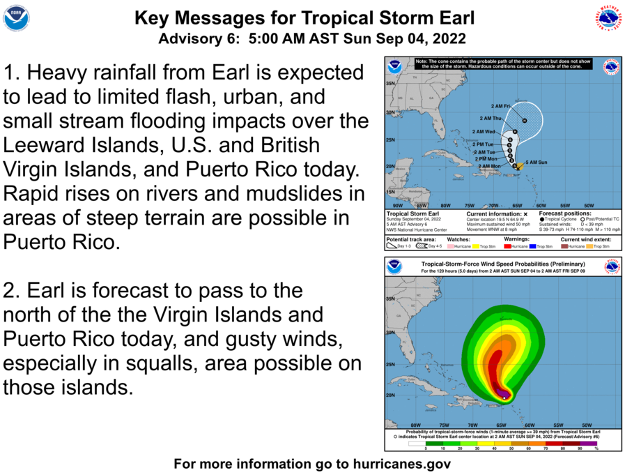
In the Atlantic, we have two systems of note, Hurricane Danielle and tropical storm Earl. Danielle is well off the coast of New England heading toward northern Europe while Earl is expected to take the same route.
Forecast Discussion
-- Scattered showers and t-storms today, mainly south --

A surface cold front continues to make steady southward progress
through southern Lower Michigan. In its wake, low stratus is
extensive, and short-range guidance suggests that clouds will
persist in many areas today.

Aloft, a broad/diffuse trough axis remains situated over the region,
with modest forcing for ascent largely displaced to the southeast.
Given limited boundary-layer heating under extensive clouds, surface-
based instability will be meager today, with RAP guidance indicating
MLCAPE of 200-600 J/kg across the I-94 corridor by late afternoon.
HREF guidance suggests that shower/t-storm coverage will be quite
limited today, and mainly south of I-96. This seems realistic, given
the aforementioned weak lift and instability.

-- Mainly dry Mon-Tue...slight chance of showers south --

The large-scale pattern affecting the region will change little
through Tue. However, gradual/modest boundary-layer drying will be
aided by sustained ENE low-level flow. A few showers are possible
each day, mainly south of I-96, but most locations will remain
dry. Cloud cover is also expected to be more extensive across the
southern portion of the forecast area during this timeframe.

-- Dry/settled conditions expected Wed-Fri --

Global ensembles have recently shown better consensus regarding key
features during the mid/late-week period. A pronounced mid/upper
anticyclone is forecast to remain situated over the western CONUS
through late week. An associated ridge axis extending from this
feature will propagate eastward while amplifying, resulting in a
strong 500-mb positive height anomaly near Hudson Bay by Tue. This
will subsequently facilitate development of a cutoff low during the
Wed/Thu timeframe, most likely over the lower MS valley.  Regarding
this cutoff low, EPS and GEFS ensemble means have shown better
run-to-run consistency in the evolution/placement of this
feature, and ensemble spread has narrowed as well. The emerging
signal is that this low will remain sufficiently south of the
region, favoring dry conditions overall through Fri. At the
surface, an elongated area of high pressure should build into the
region on Wed night.

The deterministic ECMWF suggests that a shortwave trough and
associated cold front may approach the region on Fri night or Sat,
but ensemble support for this scenario is currently tenuous.
The high in GR was 69 degrees! Wow! Our cool pattern continues!
What a difference from yesterday. We went to an outdoor wedding. It was horribly hot. The reception was in a barn and it was miserable. Everyone was soaked with sweat. About 7pm the front came through with a rush of cool dry wind. It felt amazing.
What a day! Will it even hit 75 degrees today?
I picked up 0.95” of rain yesterday. Yet another big soaking rain! We now sit at a cool 63 at my house.
The official H/L yesterday at Grand Rapids was 85/64 there was a trace of rain reported at GRR and there was 77% of possible sunshine. Here in MBY I recorded 0.05” of rain fall. The overnight low at GRR looks to be the current temperature of 64 here at my house the overnight low and current temperature is 65. For today the average H/L is now down to 78/57 the record high of 94 was set in 1898 and 1925. The record low of 38 was set in 1924. The next several days look to be near or just above… Read more »