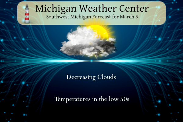
Yesterday we had .56 of an inch of rainfall with a high of 54°. A decrease in clouds is expected today from north to south. By late afternoon most locations should see sunshine. Normal highs this time of year are around 40 and we will be up around 50 today. A cooling northwest wind of 10 to 20 mph can be expected though. We will be dry today and Thursday with rain returning on Friday.
NWS Forecast
Sky Warn
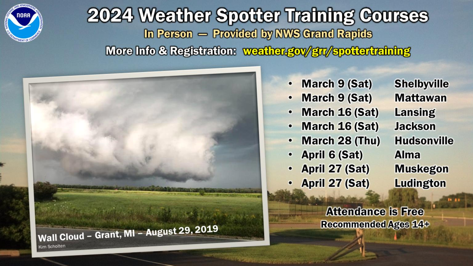
Want to learn how to identify and report severe weather to the NWS and provide a helpful public service? You’re invited to any of our upcoming in-person spotter training courses this season—everyone is welcome! Please visit weather.gov/grr/spottertraining for details. Registration is requested at some locations.
| Session Date | Session Time | Location | Registration |
| Saturday, March 9 | 10 am EST | Luella Collins Community Center 419 126th Ave, Shelbyville, MI 49344 |
Click Here To Register |
| Saturday, March 9 | 2 pm EST | Mattawan High School 56720 Murray St, Mattawan, MI 49071 |
No Registration Needed |
| Saturday, March 16 | 10 am EDT | Lansing Community College West Campus 5708 Cornerstone Dr, Lansing, MI 48917 |
Click Here to Register |
| Saturday, March 16 | 2pm EDT | Jackson County Health Department Room #005 1715 Lansing Ave. Jackson, MI 49202 |
No Registration Needed |
| Thursday, March 28 | 630 pm EDT | Hudsonville High School 5155 32nd Ave, Hudsonville, MI 49426 |
Click Here to Register |
| Saturday, April 6 | 10 am EDT | Alma College Swanson Academic Center (SAC) room 113 614 W Superior St, Alma, MI 48801 |
No Registration Needed |
| Saturday, April 27 | 10 am EDT | Room 1300 Stevenson Center – Muskegon Community College 221 S. Quarterline Road Muskegon, MI 49442 |
No Registration Needed |
| Saturday, April 27 | 2 pm EDT | Ludington, MI – Location TBD | Email to register: emergencymanagement@masoncounty.net |
Online, self-paced training can be obtained by taking this online MetEd course through the COMET Program. You can also learn more about meteorology and our atmosphere at JetStream – An Online School for Weather. Once you have completed training, contact the Emergency Management office in your city/county to find out what you can do to become involved with their spotter program.
Weather History
1956: Severe thunderstorms moved across Lower Michigan ahead of a strong cold front. A tornado destroyed five barns and unroofed homes in North Blendon and Bauer in Ottawa County.
On March 6, 1960, the overnight temperature dropped to -6 degrees in Flint, which was the record low temperature for the day. Curiously enough, the very next year, in 1961, the daytime temperature rose to 64 degrees, setting the record high temperature for the day.
1875: Heavy snow fell in much of Arkansas, with the highest amounts in the central and west. Twelve inches of snow fell at Little Rock, which remains the highest calendar day snowfall on record in the capital city. 30 inches fell near Mena. The image below is from a tweet by the NWS Office in Little Rock, Arkansas.

1908: A tropical storm developed about 500 miles northeast of San Juan, Puerto Rice, on March 6. The storm intensified to Category 2 strength near the Leeward Islands of Saint-Barthélemy and Saint Kitts. Since 1842, this was the only hurricane to develop in the Atlantic Ocean in March. Click HERE for more information from the Weather Channel.
1962: The strongest nor’easter of this century struck the Mid-Atlantic Region on March 5-9, 1962. It is known as the “Ash Wednesday Storm” and caused over $200 million (1962 dollars) in property damage and significant coastal erosion from North Carolina to Long Island, New York. It was estimated to have destroyed or significantly damaged 45,000 homes in New Jersey alone. The Red Cross recorded that the storm killed 40 people. It hit during “Spring Tide.” When the sun and moon are in phase, they produce a higher-than-average astronomical tide. Water reached nine feet at Norfolk (flooding begins around five feet). Houses were toppled into the ocean, and boardwalks were broken and twisted. The islands of Chincoteague and Assateague, Maryland, were completely underwater. Ocean City, Maryland, sustained significant damage, mainly to the island’s south end. Winds up to 70 mph built 40-foot waves at sea. Heavy snow fell in the Appalachian Mountains. Big Meadows, southeast of Luray, recorded Virginia’s greatest 24-hour snowfall with 33 inches and the most significant single storm snowfall with 42 inches. (Luray, Virginia reported 33.5 inches on March 2-3, 1994, making this later snow their maximum 24-hour snowfall total.) Roads were blocked, and electrical service was out for several days. Washington and Baltimore fell into the mixed precipitation zone. The Ash Wednesday storm is noteworthy for producing devastating tidal flooding along the Atlantic Coast and record snows and the interior of Virginia. The extremely high tides and massive waves caused tremendous damage -worse than many hurricanes that have hit the region. Along the Atlantic Coast, tide ran for 2 to 6 ft above average with 20 to 40 ft waves crashing ashore. National Airport received only 4 inches of snow with a liquid equivalent of 1.33 inches. However, close-in suburbs, such as Silver Spring, Maryland, and Falls Church, Virginia, received 11 inches of snow. Outlying areas such as Rockville, Maryland, received 19 inches of snow, and Leesburg, Virginia, received 20 inches of snow. Other snow totals included 15 inches at Richmond; 23 inches at Culpeper; 26 inches at Charlottesville; 32 inches at Winchester; and 35 inches at Fort Royal, Virginia, and Big Meadows on the Skyline Drive top the list with 42 inches of snow. Click HERE for more information from the Washington Post. Click HERE for additional information from the Weather Channel.
2004: More snow fell on March 6, 2004, than ever recorded for a single day in March since the Korea Meteorological Administration began keeping records in 1904. According to news reports, the city of Daejon (Taejon) in central South Korea received 19 inches of snow on Friday, with an additional 6 inches (15 centimeters) forecast for Saturday. As the storm moved away from the peninsula on March 7. Click HERE for more information from NASA Earth Observatory.
2010: At least seven funnel clouds were observed along the Orange County coast in southern California. Two were spotted near John Wayne Airport.

2014: The Great Lakes saw some of their worst ice covers in nearly four decades because of a frigid winter with months of below-freezing temperatures in large sections of the northern United States, the National Ocean and Atmospheric Administration said. As of Mach 6, 2014, the federal agency said that 92.2 percent of the five lakes were under ice, breaking a record set in 1973 but still short of the 94.7 percent established in 1979.
2017: Early data from the GOES-East satellite warned forecasters from the NWS office in Dodge City, Kansas, about a wildfire before any 911 calls were made. As a result, they were able to start planning evacuations sooner and saving lives. Click HERE for a tweet from NOAA Satellites.
2017: A line of storms brought widespread wind damage and tornadoes to Minnesota, Wisconsin, Iowa, and northern Missouri. Click HERE for more information from the NWS Office in La Crosse, Wisconsin.
Forecast Discussion
- Dry and Occasional Sun Wednesday and Thursday

A few stray showers have formed near the I94 corridor this morning
in response to favorable upper-level jet dynamics. Have added a few
hours of low (15-25 percent) PoPs near I94. These will diminish near
daybreak as forcing weakens. Generally dry conditions are expected
for the rest of the day and Thursday as drier air arrives in the
northeast flow. Combined with high pressure, this will keep
precipitation out of the forecast over the next 36 hours. While the
low level moisture and upper-level trough associated with this cloud
cover are lingering, their slow departure will finally begin to
clear skies and offer chances for sunshine, especially later today.
There will be more cloud cover Thursday as high clouds move in but
it won`t be completely overcast. Look for highs in the 50s both
days, which is above average for this time of year.

- Rain moves in Friday and continues into Saturday

The most consequential weather of the 7 day forecast will occur on
Friday and Saturday. The primary players in the details of the
forecast can be seen clearly tonight in water vapor imagery. Two
distinct upper waves are the main features, one in the Gulf of
Alaska and another spinning towards the California coast. As we move
into the Friday time frame, both of these shortwaves will be
converging on the Great Lakes. On Friday, respectable moisture
levels for early March will be moving into the region on deep
southerly flow. PWATs increase to around an inch, 850mb dew points
peak around +6C and surface dew points rise to near 50F in the far
south of the state. We expect rain to develop Friday morning and
continue into Saturday morning. Rainfall totals are a bit higher in
the GFS (0.50 to 1.00) than the ECMWF (0.30 to 0.80). Not expecting
any thunder, but a widespread soaking rain is looking likely.

- Chance for snow on Saturday

The question mark in the forecast really comes Saturday and is
related to the amount of phasing that occurs between the two
aforementioned shortwaves. The GFS phases the shortwaves more and
produces a deeper low on Saturday... 990mb (GFS) vs 1002mb (ECWMF).
The GFS pulls the colder air in more efficiently and before the
precipitation shuts off. There is potential for a strip of snow
through the forecast area if the GFS solution verifies. Given how
far away the shortwaves are in distance and how far out in time this
is it is a bit tough to say which solution is correct. We would not
be surprised though if the deeper and colder solution of the GFS
verifies. We will be watching this time frame closely going forward.
The snow if it does occur would be of the heavy wet variety given
surface temperatures in the low to mid 30s.

Otherwise, we are looking for quiet weather Sunday through Tuesday
as it will be dominated by ridging. A warming trend will occur on
these 3 days as we rise from -10C readings on Saturday night at
850mb to +5C on Tuesday. This translates to highs over the weekend
in 30s moderating to the low 50s by Tuesday.
What do we have here?
https://www.pivotalweather.com/model.php?p=snku_acc-imp&rh=2024030618&fh=384
Seeing lots of buds starting on some trees and even small green leaves poking out of a particular type of bush (it’s usually the one that gets them first in the spring. There are lots of them around. I noticed it while out for a walk near the Grand River)
I have to say seeing buds this early may be the earliest I’ve ever seen other than maybe 2012. Also, I Finnallly seen a Robin. After hearing them but not seeing them I saw one in the tree by my deck on Monday.
After this dreadfully bad winter, I surely hope we have a cold summer! That would be incredible! Bring it on! Rock n roll will never die!
Didn’t you predict 90″ or 100″ of snow this year along with cold? Your predictions are no longer relevant I’m afraid.
You are 100% incorrect as usual! You have lost all credibility! Wow!
More than 18 degrees above average. The warmest start to March ever recorded?
And no end in sight!! Who wouldn’t want these beautiful warm temps that we are enjoying this winter???
https://weather.com/weather/tenday/l/52aab230ef88e4f2bb12857231a5dd58392e78a71b90e01d57a11d827658eb55
I just saved 35% on my heating bill versus last year. Who wouldn’t want no winter and an early spring?
Same, it has been great! Especially considering the terrible economy it has been these past three years.
I agree with all the comments except for what this warm weather might do to our fruit orchards. I hope a hard freeze after buds start to appear doesn’t wipe out those crops.
Very true Jim. Don’t want that!
You know it Jim; with all the warm weather fanatics on here they could care less about global warming and that an extremely warm winter will lead to a multitude negative consequences! You have just pointed out one of the many negative results of a warm winter! Keep the facts coming!
The official H/L yesterday was 64/42. Even though the high happened at 2 AM it was the 2nd warmest high for the date also the low of 42 was the 2nd warmest low for the date. There was 0.61” of rain fall (here in MBY I had a total of 0.74”) there was no sunshine. For today the average H/L is 40/24 the record high of 68 was in 1973 and the record low of 0 was in 1901 and 1920. The most rainfall of 0.68” was in 1894 the most snowfall of 5.6” was in 1971 the most on… Read more »