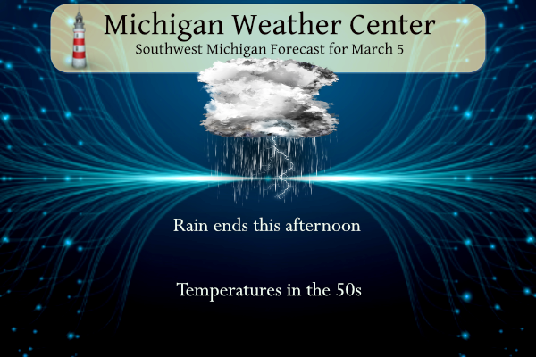
Yesterday we had a record high temperature of 71° in Otsego. We currently have 52° at 6 am with rain along with some thunder and lightning. With the passage of a cold front temperatures will remain in the 50s. Highs in the 50s are expected through Friday, before colder air moves in for the weekend.
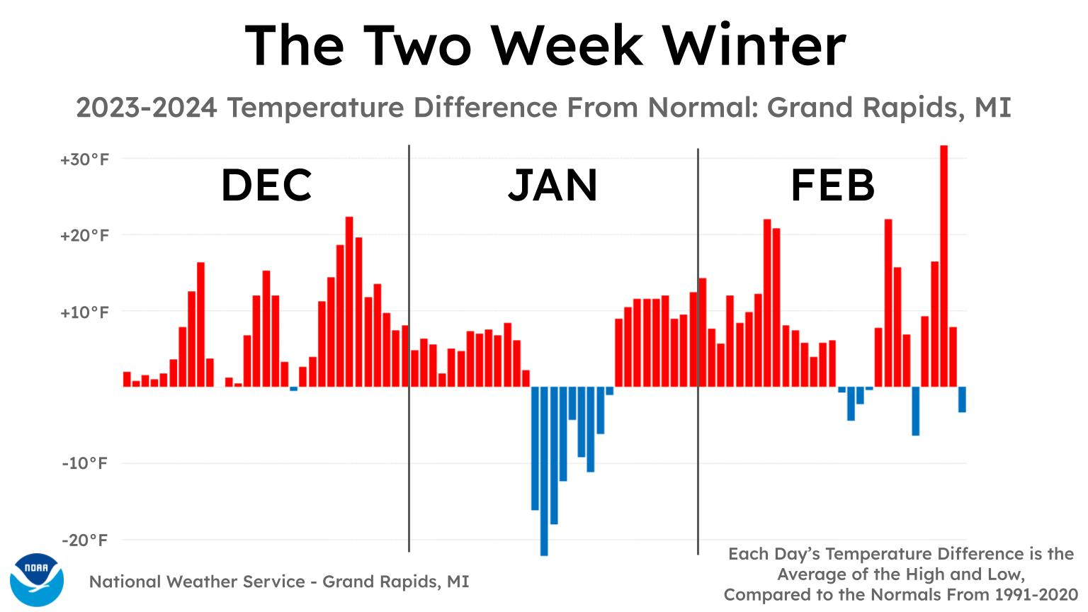
The coldest and snowiest three months of the year, on average, are December, January, and February. With the coldest part of this winter now in the rearview mirror, a look back at each day’s temperature difference from normal reveals just how sparse the cold air was in Michigan.
SkyWarn Training Schedule
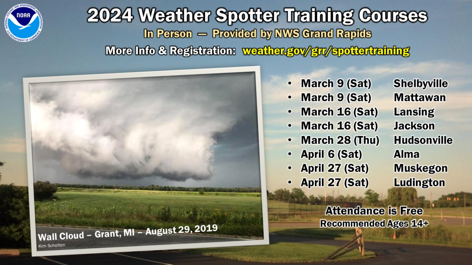
Want to learn how to identify and report severe weather to the NWS and provide a helpful public service? You’re invited to any of our upcoming in-person spotter training courses this season—everyone is welcome! Please visit weather.gov/grr/spottertraining for details. Registration is requested at some locations.
NWS Forecast
Weather History
1948: Arctic high pressure dominates the first half of March with record lows this morning of 8 below zero at Grand Rapids and 5 below at Muskegon.
1976: Thunderstorms move over cold air near the ground to produce one of the worst ice storms in history across Wisconsin and Lower Michigan. From 2 to 5 inches of ice builds up on trees and power lines, resulting in hundreds of thousands of people without power, some for as long as ten days.
On March 5, 1900, a two-day snowstorm ended which dropped a total of 16.1 inches of snow in Detroit. This is the third heaviest snowstorm in Detroit since 1880! The storm was the last storm in a series of remarkable snowstorms which saw the 7th heaviest snowstorm on February 19, 1900, and then the 4th heaviest snowstorm on February 28-March 1, 1900. The March 1st and March 5th snowstorms helped to make it the snowiest March on record in Detroit, with 30.2″ of snowfall for the month. This is 23.2″ above average!
Also on March 5, 1948, there was an all-time high pressure observed at Detroit of 31.04 inches.
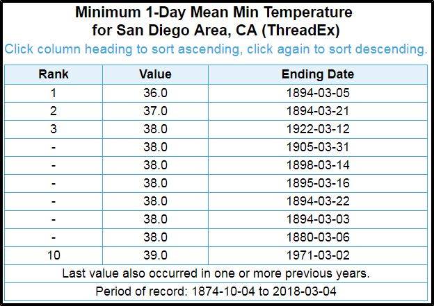
1894: The low temperature of 36 degrees in San Diego, California, on this day was the lowest on record for March.
4-6, 1959: In Iowa, the record-breaking snowstorm on March 4-6 began with light snow in western Iowa on the morning of the 4th, then spread across the state and intensified with heavy snow falling from the night of the 4th through the 5th and into the early morning on the 6th in eastern Iowa. The snowfall and its subsequent effects were less severe in western Iowa and grew progressively worse, moving eastward. In central Iowa, snowfall amounts were generally 6 to 10 inches. In contrast, in eastern Iowa, a swath of about 12 to 20 inches of snow fell roughly from Appanoose County through Tama County and northeast to Allamakee County. Reported storm total snowfall amounts included 12.9 inches at Waterloo, 14.5 inches at Decorah, 16.0 inches at Oelwein, 17.0 inches at Oskaloosa, 17.6 inches at Dubuque, 19.8 inches at Marshalltown, where 17.8 inches fell in just 24 hours, and 22.0 inches at Fayette where 21.0 inches fell in 24 hours. Winds strengthened steadily during the storm, with speeds reaching 30 to 50 mph at times and causing extensive blowing and drifting of snow. Drifts 6 to 10 feet deep were common, and in northeastern Iowa, a few locations reported drifts 15 to 20 feet deep.

1959: Near blizzard conditions occurred over northern and central Oklahoma. Up to seven inches of snow fell and winds up to 50 mph created snow drifts 4 to 8 feet deep. In Edmond, a bus slid off the road into a ditch and overturned, injuring 16 people. The image below is from Storm Data.

1966: A plane crashes near Mount Fuji in Japan after severe turbulence. Aviation-safety.net said the probable cause was, “The aircraft suddenly encountered abnormally severe turbulence over Gotemba City, which imposed a gust load considerably over the design limit.” All 124 people on board were killed in the crash. Click HERE for more information. Click HERE for more details from BBC.

1989: A F2 tornado killed one person and injured six others in Heard County, Georgia. A stronger F3 tornado injured 23 persons and caused more than $5 million in damage around Grantville, Georgia.

The image above is from Storm Data.
1998: A thunderstorm dropped dime to golfball size hail along its track from McLain to Leakesville, Mississippi. The most severe damage was around the city of Leakesville. Hail depth was six to twelve inches throughout the city. The elementary school in Leakesville reported hail drifts to the bottom of the school’s windows.

2007: The morning temperature dropped to 51 degrees below zero at Key Lake, Saskatchewan, Canada.
Forecast Discussion
-Showers and Storms Wind Down This Afternoon/Evening

Radar shows widespread showers occuring across West Michigan this
morning, with a few embedded thunderstorms. The best chance for
thunderstorms will be through 12z (7am) before the axis of greatest
instability shifts east though an isolated thunderstorm cannot be
ruled out during the day Tuesday. The cold front driving the shower
activity moves southeast through the day with showers ending from
northwest to southeast. Showers end near Ludington mid this morning,
lasting towards Holland-Grand Rapids-Mount Pleasant early-mid
afternoon, and ending for areas towards Jackson late Tuesday
afternoon/early Tuesday evening. Additional rainfall will be on
the order of 0.25"-0.5"

-Dry conditions Wednesday

Temperatures cool off significantly Tuesday night compared to the
past few mornings as north-northeast winds bring cooler and drier
air into West Michigan. Low temperatures Tuesday night look to be
in the upper 20s to mid 30s, highest south of I96.

Dry conditions are then expected for Wednesday with decreasing cloud
cover as high pressure and a drier air mass continue to move into
lower Michigan. Highs look to generally be in the upper 40s to mid
50s, warmest near and west of US131, and coolest for the 127
corridor where northeast winds bring in a cooler airmass from Lake
Huron.

-Cooler with rain and perhaps snow this weekend

Only minor tweaks to the going forecast are needed. For several
model runs, both the ECMWF and GFS have pointed toward a potential
phasing of northern and southern stream waves as they move toward
the Great Lakes late this week; that trend continues with the 00z
runs. The main difference between the current run and yesterday is
the current run is a tad warmer, which means a lower chance of snow.
The other noticeable change is that QPF is a bit higher.
Ensembles point toward a 50-70 percent chance (from north to south
across the cwa) of greater than a quarter inch of precipitation
Friday into Saturday. Indeed, the ECMWF ensemble mean is closer to
0.4 inches, which is good news considering the abnormally dry
conditions across the region.

The GFS is quicker bringing in rain from the south than the ECMWF is
and begins the precipitation Friday morning, whereas the ECMWF holds
off until Friday afternoon. Our grids reflect somewhat of a
compromise with rain developing in the far southwest cwa Friday
morning and then overspreading the rest of the cwa throughout the
day and continuing Friday night and Saturday. As colder air works in
from the north behind the northern stream short wave, we`ll likely
see some rain/snow mix and perhaps a total change over to light snow
before it ends Sunday morning.

Highs in the 50s expected Wednesday and Thursday before cooling off
as rain begins Friday; highs in the 40s Friday and Saturday. Sunday
will be the coolest day with temperatures likely remaining in the
upper 30s. The colder air will be short lived. Once the upper trough
moves east, ridging will take its place highs will rebound into the
mid 40s Monday.
This could have been the worst winter ever! Absolutely horrible!
https://www.mlive.com/weather/2024/03/we-had-a-2-week-winter-in-the-traverse-city-area-this-year-data-shows.html
Wow. Nice graphic.
Horrible winter, even up North!
Wow, that’s incredible! I think I’ll print that out and hang it on the wall!
After a blowtorch February, March is currently +17.7 degrees above average. Wow!
57 with light rain the lightning/thunder here currently, but the cooler temps are on the doorstep.
With light rain falling the current temperature here in MBY is now down to 48 it was above 50 until just before 7 AM. I now have 0.58″ of rainfall so far.
Slim
New record highs were set yesterday at Grand Rapids 70, Lansing 69 and Muskegon 67. A record was tied at Kalamazoo with 72. The 71 at Holland is just short of the record of 72. Record warm minimums were set at Grand Rapids 49, Muskegon 52 and Holland 51.
Slim
The official H/L yesterday was 70/49 both were records for the date. There was no rainfall before midnight the sun was out 40% of the time and the highest wind gust was 32 MPH out of the S. For today the average H/L is now up to 40/24. The record high of 68 was set in 1894 and 1983 the record low of -8 was set in 1948. The record rainfall is 0.82” in 2004 the record snowfall is 7.4” in 1999. The most snow on the ground is 19” in 2014. Last year the H/L was 51/31.
Slim