
There is a chance of rain and a thundershower today before we start a long dry stretch. Rainfall amounts don’t look to be much, maybe a few hundredths of an inch in SW Michigan with a bit more north of US 10.

Showers and a few storms are possible today but no severe weather is expected. In any given location, rain is likely to last from 1 to 3 hours before ending. Some areas may avoid the rain altogether.

Large wave action and dangerous currents will develop behind a cold front today into Wednesday. Steer clear of the pier and stay dry when waves are high!
The big story is Idalia beginning to move towards Florida.

U.S.A and Global Events for August 29th:
1960: The storm that would become Hurricane Donna forms near Cape Verde off the African coast. It would go on to cause 150 deaths from Puerto Rico to New England over the next two weeks. Click HERE for more information from the History Channel.
2005: Hurricane Katrina makes landfall near New Orleans, Louisiana, as a Category 3 hurricane. Despite being only the third most powerful storm of the 2005 hurricane season, Katrina was one of the worst natural disasters in the history of the United States. Click HERE for more information from the History Channel.
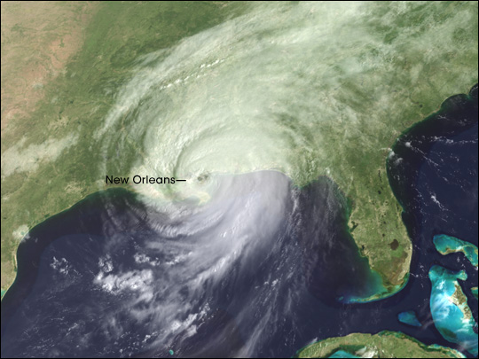
The image is courtesy of NASA.
Grand Rapids Forecast
8 29 grrForecast Discussion
.SHORT TERM...(Today through Wednesday)

A cold front approaching from the nw will bring increasing cloud
cover today with showers and scattered convection. The 00Z HREF
suggests sb/mu cape values will reach around 1000-1250 j/kg by
this afternoon near to mainly east of US-131.

Severe wx is not expected given lack of stronger instability and
stronger shear and the expectation of relatively weak updrafts
with any convection. However some isolated gusty winds with
relatively stronger convection are possible given potential for
steep (nearly dry adiabatic) low level lapse rates.

Any lingering showers and isolated convection over our eastern
fcst area this evening will end quickly with dry wx for the
overnight period. Fair and cooler wx will return Wednesday as a
sfc high pressure ridge buids in.

.LONG TERM...(Wednesday night through Monday)

- Dry and Warm Weather Favored Late Week Through Labor Day

Ensemble guidance is favoring a multi-day period of dry weather from
Thursday into Labor Day along with warming temperatures that could
reach 10 to 15 degrees above normal for Sunday and Monday.

ECE/GEFS ensemble mean 500 mb height anomalies are shown to increase
to about 2 standard deviations above normal Sunday into Monday as
upper ridging is favored to intensify over the Great Lakes region.
Warm air advection around this ridge ensues, and 850 mb temperatures
are shown to be 20C or a bit higher off the ensemble mean guidance.
As was the case with our prior heat event on August 23 and 24, the
GEFS/GFS 850 mb temps and corresponding surface temps are just too
high. With that previous event, the GEFS/GFS guidance was several
degrees off and in certain parts of the Midwest/Great Lakes region
it was off by 10 to 15 degrees too high. So, "buyer beware" if you
are thinking of running your forecast temperatures straight off the
GEFS/GFS. The current NBM has upper 80s to low 90s across the region
Sunday into Monday. The ECE box and whiskers plot for Sunday and
Monday`s high temperatures is not showing much spread at all, pretty
well clustering from the upper 80s to the low 90s. So, the NBM seems
to have a reasonable handle on things so far. The heat could last
into Tuesday as well.

In terms of rainfall, a very limited opportunity may exist Saturday
into Saturday night as the upper ridge tries to establish itself but
we will be just on the periphery of it with a tilting LLJ to our
west to allow the theoretical possibility for something to develop.
But ensemble guidance is showing less than a 10% chance for any
measurable precipitation during that period, so rain is unlikely at
this point and we will maintain a dry forecast.
Get ready for 3 nights in a row with low temps near or below 50 degrees! Incredible!!! Wow!!!
I would imagine Summer 23 will end up with more below normal temperatures then above normal days Summer 23 had been a beautiful one hardly any hot and humidity long stretches like Summers past thats how I am going to remember Summer 23 step outside today and the wind is chilling I love it!! INDY
No heat waves and below normal temps! What could be better???
Warm up on the horizon:
https://www.mlive.com/weather/2023/08/hot-weather-roars-back-to-michigan-in-extended-forecast.html
The cleanup continues at my house. Still damage to be picked up. We completely cut down one of our pines it was to damaged to keep on the property. The maple tree at the corner of our lot sustained damage. Sad because it was probably one of the best on the property and turns a vibrant orange in the fall. It’s still standing we will keep what’s left but no doubt looks different. We lost many white pine branches. The people north of us lost many trees. I tell you what we went from a fairly quiet severe weather season… Read more »
We will have to wait and see how many days of 90 or better September has but so far this warm season here is how many days of 90 or better at the major Michigan stations. Grand Rapids 11, Lansing 10, Muskegon 12, Holland 8, Detroit and Flint 2. Saginaw 5. Alpena 6, Houghton Lake 4, Sault Ste Marie and Houghton 0 and Marquette 3. It has been a very much hit and miss with 90° days this year.
Slim
My weather app shows 4 more below normal temp days in a row! What a stretch of below normal temps! Incredible!
This meteorological summer will end up cooler than average at most Michigan locations with Lansing and Muskegon being the exceptions. Will update when September is here.
Slim
How is the at possible with all the warm weather hype on here? Some even have said we have had many months in a row with above normal temps! How wrong can they be or
maybe they are just full of lies? Incredible
stretch of near to below normal temps! Wow!
Met Fall starts in a few days, but it looks like astronomical Summer continues. My weather app has 3 more days in the 90’s starting Sunday. I sure hope it doesn’t come with the humidity we had last week. That was unbearable.
I think Grand Rapids is at 11 90 degree days this year? I could be wrong. Either way above average for total 90s in a given summer. At my house we are at I believe 12 or 13.
Close to the same here, I think we’re at 14. Anything over 1 is to many for me so double digit days is waaaaay to many.
Here comes mores lows in the 40’s as the below normal temp pattern keeps going! Wow!
Here comes more heat!
It looks GR will see yet another month with below normal temps! This cool pattern has been months on end with no heat waves! What a stretch! Rock n Roll will never die!
The first week of September looks incredible. Very warm conditions. CPC highlights us in the well above average category. Looks great for those with Labor Day plans.
Yesterday was a very pleasant late summer day with a H/L of 77/50. There was no rain fall and the sun was out 89% of the possible time. The state high was 80 at Kalamazoo the low was a chilly 39 at Pellston. All Michigan locations made it to 70 or better except Copper Harbor where the high only reached 69. For today the average H/L is 79/59 the record high of 95 was set in 1953 the record low of 41 was set in 1982. The record rain fall of 1.55” was in 1955. Last year the H/L was… Read more »
There is a chance of showers today it will turn cool for Tomorrow and Thursday then become warm to very warm and dry for the Labor Day weekend. Highs will range from around 70 tomorrow to the upper 80’s on Labor Day lows with range from the 50’s then warm up well into the 60’s late in the weekend.
Slim