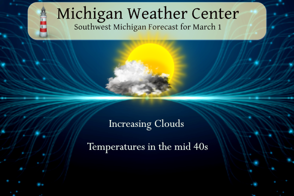
It appears Meteorological winter is going out with a whimper though the official end isn’t until March 19 this winter was mainly a bust for snow lovers. Partly to mostly sunny skies are expected through Sunday, then rain chances will increase by Monday afternoon. Very mild weather is expected with temperatures warming to around 70 by Monday to usher in an early spring this year.
NWS Forecast
Weather History
1882: March comes in like a lamb with high temperatures in the 60s. Lansing hits 64 degrees and goes on to reach 66 degrees the next day. This continued the warmth from the previous month, which was the warmest February on record at Lansing.
1962: Bitterly cold weather begins the month with morning lows below zero and high temperatures only around 10 degrees.
On March 1, 2018 a heavy, wet accumulating snow fell. Many areas only received between 1 and 3 inches of accumulation. However, the elevated terrain of Oakland, Washtenaw, Livingston, and far western Wayne County cashed in during the most intense portion of the storm. Rates briefly reached 1-2″/hour resulting in a relatively small corridor of 6-8″ from Ann Arbor to Wixom to White Lake. A peak measurement of 8.5″ was taken near the town of Wixom.
Also on March 1, 2016, yet another significant snowstorm occurred despite all of SE Michigan being 1 day removed from one of its warmest winters on record. Over a foot fell fell in the Thumb with Harbor Beach topping the list at 14 inches. Virtually everyone north of M-59 received at least 6 inches. At 9.5 inches, it ranks 22nd on the all-time list of snowstorms for Flint.
Also on March 1, 2014, light snow intensified during the afternoon and peaked in intensity overnight. Rather uniform snowfall totals of 3 to 4.5 inches were observed, although much of Bay and Midland Counties measured less than an inch.
Also on March 1, 1900, a snowstorm dropped 14.0 inches of snow on Detroit. This storm was the 4th heaviest snowstorm in Detroit history. It lasted from February 28th to March 1st. The storm was the second storm in a series of remarkable snowstorms which saw the 7th heaviest snowstorm on February 19, 1900, and then the 3rd heaviest snowstorm on March 4-5th, 1900. In fact, in that week period (Feb. 28th-Mar. 6th), more than 34 /34.2/ inches of snow fell on Downtown Detroit (see more on March 5th)!
Also on March 1, 2007, a winter storm left the thumb region with 2 to 4 inches of snow and up to 1 inch of ice. Thousands of people were left without power in the worst ice storm in the thumb since 1976.
1849: The first recorded weather observation for Blowing Green, Kentucky, occurred on March 1, 1849.
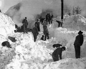
1910: The worst avalanche in US history regarding lives lost occurred in Wellington, Washington. Heavy snow occurred from February 26 through the 28th, which blocked the rail lines. Weather conditions turned on the 28th, with a thunderstorm occurring over the area. Just after 1 AM on March 1, a ten to 14-foot-high mass of snow broke free from the mountainside and pushed the trains 150 feet down into the Tye River Gorge. In all, 96 people were killed by this avalanche. Click HERE for more information from the History Channel. Click HERE for pictures from the Seattle Times.

1980: March 1-3rd, North Carolina experienced a significant winter storm with heavy snow across the entire state and near blizzard conditions in the eastern part of the state. Widespread snowfall totals of 12 to 18 inches were observed over Eastern North Carolina, with localized amounts ranging up to 22 inches at Morehead City and 25 inches at Elizabeth City, with unofficial reports of up to 30 inches at Emerald Isle and Cherry Point. Click HERE for more information from the NWS Office in Morehead City, North Carolina.
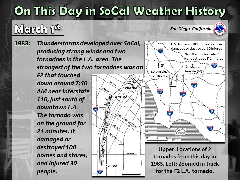
1983: Two tornadoes caused damage in the Los Angeles areas during the morning hours. The strongest tornado was an F2 on the ground for 21 minutes.
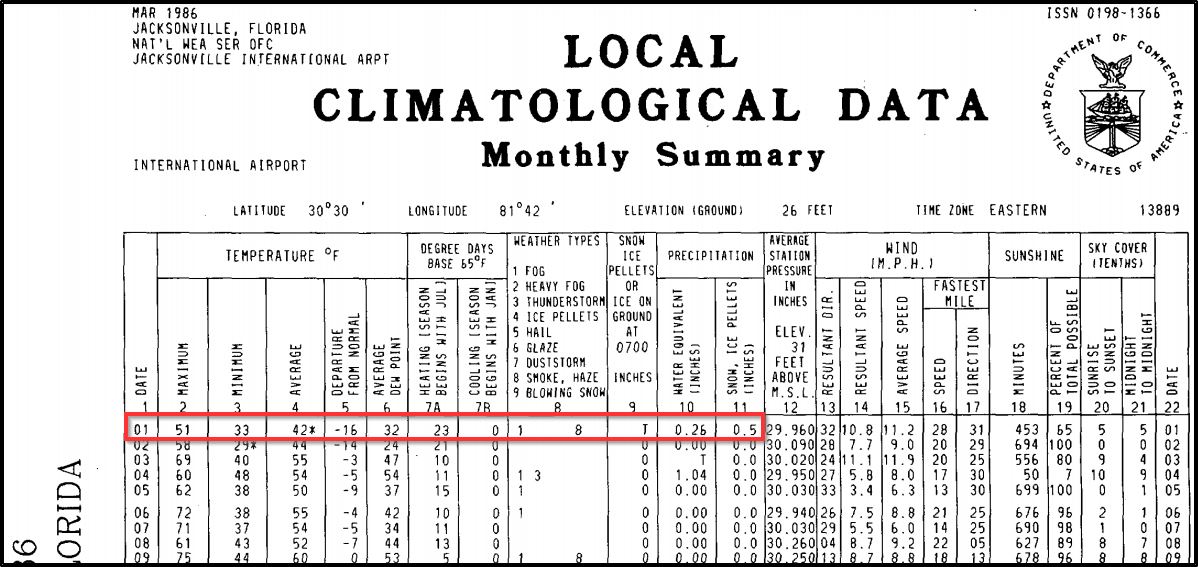
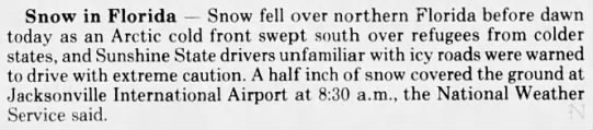
1986: Light snow fell during the early morning hour in Jacksonville, Florida. A half inch of snow was reported at the Jacksonville International Airport, the highest amount ever recorded in March.
2006: The day’s temperature of 93 degrees at the Dallas/Fort Worth Airport in Texas broke a 107-year-old record. Other hot North Texas cities included Wichita Falls at 96 degrees and Fort Worth Meacham Airport at 90 degrees.
2007: An EF4 tornado traveled 10 miles through Enterprise, Alabama. The storm caused nine fatalities and injured 50 people. Click HERE for more information from the NWS Office in Tallahassee, Florida. Click HERE for more details from TornadoTalk.com

Above is an aerial view of Enterprise High School.

Forecast Discussion
- Small chance of rain late today far South, otherwise dry weekend

We are starting out the day this morning clear across most of Lower
Michigan. Upper ridging is dominating the weather for the region
this morning, and a short wave ridge ahead of the wave over MO is
also helping to reinforce the subsidence overhead. Lots of dry air
as a result.

We will see the high clouds spread in from the SW this afternoon as
the short wave trough over MO will lift up to the Southern Great
Lakes by this evening. We have added some small pops (15%) across
the southern third of the area for late this afternoon and early
this evening.

There are a lot of things going against this producing much rain for
our area. As the wave approaches, we actually see the low level
winds decrease a little. A low level jet gets going SE of the area
later in the evening, focusing the forcing to the SE. Also, some
better moisture in the lower levels is just starting to approach the
area, before it gets swept east. Some locations may see barely
measurable rain, but it would not be very much with the lack of
dynamics, and dry air needed to be overcome.

After the wave moves completely by the area, the long wave upper
ridge axis to our west will re-establish itself, and bring more
sunshine and warming temperatures to the area for Saturday.
Southerly winds picking up will bring 850 mb temps up to around +6C
late on Saturday, supporting highs in the 50s.

-Mild end to the weekend, Records possible Monday

Low pressure over the Red River of the North Valley will strengthen
Sunday and southwest winds ahead of over the Plains will bring
warmer air into the Great Lakes. We`ll see quite a bit of sunshine
Sunday as h8 temps increase to 12c resulting in surface temperatures
in the mid to upper 60s. Despite the warmth Sunday, we`ll likely be
a few degrees shy of record highs.  That`ll likely change Monday as
highs climb to around 70; see the Climate section below. The one
thing that could get in the way of records, though is how quickly
showers move into the region.

The strong southwest winds will be just ahead of an advancing cold
front. A wave of low pressure will ride north along the frontal
boundary and push showers and perhaps a few thunderstorms into the
cwa late Monday. If they arrive earlier, then we might just miss the
records.

- Medium high confidence for showers Monday night/Tuesday

Several models are converging on a period of showers and possible
thunderstorms Monday night and Tuesday. The ECMWF is a bit quicker
moving the front trough compared to the GFS and so would clear out
the cwa quicker Tuesday afternoon, whereas the GFS lingers showers
into Tuesday evening.

Late week looks unsettled too as broad southwest flow will bring
another low from the southern Plains toward the Great Lakes
spreading rain and snow across the cwa Friday.

Temperatures will remain above normal throughout the week.
So for us I guess we wait if March leaves us as a Lion…
Meteorological winter stats for Lansing:
Avg temp: 33.3, which is +6.9
Snowfall: 22.5”, which is -16”
NWS Bulletin for Devils Gate Summit California: …BLIZZARD WARNING REMAINS IN EFFECT FROM 4 PM THIS AFTERNOON TO 10 AM PST SUNDAY… * WHAT…Blizzard conditions likely, particularly from Friday night through Saturday. Snow accumulations of 1 to 3 feet for communities along Highway 395 except up to 5 feet in June Lakes and Mammoth Lakes. Along the Sierra Crest, 5 to 8 feet expected. Winds gusting as high as 75 mph in the lower elevations and above 120 mph over Sierra ridges. * WHERE…Mono County. * WHEN…From 4 PM this afternoon to 10 AM PST Sunday. * IMPACTS…Whiteout conditions with… Read more »
Wowzers!
Early Spring?…or Winter moves back in for March and April.
Nah….

Eeeee Eeeee blowtorch warning for possibly more record highs!
Get prepared now!
Welcome to meteorological spring! This past February with a mean of 35.4 was the new warmest of record at Grand Rapids, the mean of 36.8 was also a record at Muskegon and the mean of 36.7 was a record at Holland. The meteorological winter mean of 33.6 (tentative) is the 2nd warmest for any meteorological winter at Grand Rapids.
Slim
Thanks slim! Impressive warmth this meteorological winter. I hope we don’t break heat records this summer. It would be horrendous is we hit +30f normal in July!
The official H/L yesterday at Grand Rapids was 35/19 there was a trace of snowfall the highest wind speed was 33 MPH out of the NW. The sun was out 96% of the time. For today the average H/L is 38/23 the record high of 58 was set in 1992 and the record low of -5 was set in 1967. The record snow fall of 7.0” fell in 2016 the record rainfall of 0.97” fell in 2004. The most snow on the ground is 18” in 2014 Last year the H/L was 47/30.
Slim