My oldest son, his wife, my wife and me took a trip to Put in Bay, Ohio. Put in Bay is the name of the village on South Bass Island that it part of several Islands in lake Erie. Here is a link for some more information on South Bass Island
https://en.wikipedia.org/wiki/South_Bass_Island
There are two ferry companies that run ferries to the Island. We took the lower cost one that is the shortest boat ride to the island (about 3 miles) on that ferry you can bring you car to the island if you want to. But most people rent a golf cart and drive around the island in the cart. We rented a cart as it is a fun way to get around the island (you can do the same at Kelleys Island) We have been to both more people go to Put in Bay and it is much more crowded. Both islands have cabins and motel rooms to rent. For a laid back vacation Kelleys Island is the better of the two. As for Put in Bay it is some what similar to Mackinac Island but smaller and more built up. There are two caves on S Bass Island my son and I went through Perrys cave it is the bigger of the two. There are several things to do at the cave complex. We did just the cave thing even during mid week there were a lot of people there here is some more information on that complex
While I was not impressed with the cave I really did enjoy our trip up to the top of Perry’s Monument It was a clear day and boy from the top you can see for over 60 miles. I could see the power plants at Monroe Michigan, Canada on the other side of Lake Erie. And Even Cleveland some 60 miles to the east. There were some smoke stakes that I could see to the NW but not sure what they were. Here is some information on Perry’ Monument
https://www.nps.gov/pevi/index.htm
There are also several wineries on the island
https://putinbayreservations.com/put-in-bay-wineries/
And of course there are many different restaurants
https://putinbay.com/restaurants-dining/
Note the food is mostly good but not really great. We had sea food at Fish Bowl that was good. The Chicken Patio is also good.
We also took a side trip to the Rock in Roll Hall of Fame. I had mixed feelings about the rock hall. There is indeed a lot of items there but some of my favorite bands did not have a lot of items there. There were very few items from Bob Seger, I did not see any items from Grand Funk Railroad, The Who, The Guess Who among others. My wife did not see anything from Cher. Another issue I had with the rock hall was the merchandise area. I did not see any tee shirts or hats that I liked my son did get a t shirt but I did not like the color. Note I did get a couple of hats at Put in Bay.
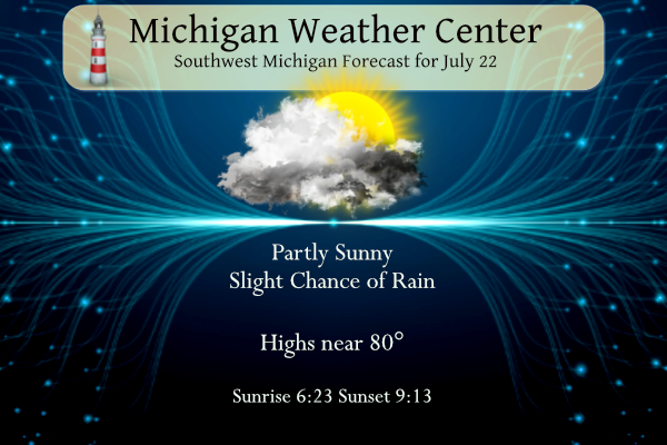
As for the weather it was great other than a lot of smoke on Monday the rest of the time it was clear and pleasantly cool with highs in the low 80’s to upper 70’s and lows in the mid 60’s
The updated CPC outlook is now out and guess what? August looks to continue the near average temperatures.
https://www.cpc.ncep.noaa.gov/products/predictions/long_range/lead14/index.php
The fall guess also looks to be near average.
https://www.cpc.ncep.noaa.gov/products/predictions/long_range/seasonal.php?lead=2
And for the upcoming winter the CPC is guessing warm and dry.
https://www.cpc.ncep.noaa.gov/products/predictions/long_range/seasonal.php?lead=5
The official H/L yesterday at Grand Rapids was 82/63 for another average temperature day Officially there was no rain fall but here at my house there was a brief shower yesterday that dropped 0.02” of rain fall that shower became much bigger as it moved east and there were some nice cumulonimbus clouds to the east. Officially there was 78% of possible sunshine. For today the average H/L is 83/63 the record high of 97 was set in 1934 and the record low of 43 was set in 1947.
There is a chance that we could tap into some really hot air next week note that is not yet in the detailed forecast for next week as highs are forecasted in the upper 80’s to near 90.
AREA FORECAST DISCUSSION
NATIONAL WEATHER SERVICE GRAND RAPIDS MI
358 AM EDT SAT JUL 22 2023
LATEST UPDATE…
SHORT TERM/LONG TERM/MARINE
SHORT TERM
(TODAY THROUGH SUNDAY)
ISSUED AT 355 AM EDT SAT JUL 22 2023
– SCATTERED SHOWERS AND STORMS TODAY AND SUNDAY
THE MAIN RISK FOR SCATTERED SHOWERS AND STORMS WILL OCCUR THIS
AFTERNOON/EVENING ALONG AND EAST OF US 131, AND MAINLY IN THAT
SAME LOCATION FOR SUNDAY. UPPER TROUGHING SWINGS THROUGH MICHIGAN
TODAY WHILE AT THE SURFACE A LAKE BREEZE WILL PROVIDE MESOSCALE
SUPPORT TO HELP POP SCATTERED SHOWERS AND THUNDERSTORMS ALONG AND
EAST OF US 131 THIS AFTERNOON AND EVENING. SBCAPE OF 500-1000 J/KG
WILL SUPPORT THE POSSIBILITY FOR A FEW STORMS. GIVEN AN
ENVIRONMENT WITH LITTLE SHEAR, ANY SHOWERS THAT DEVELOP WILL
QUICKLY BECOME OUTFLOW DOMINANT AND SPREAD OUTFLOW BOUNDARIES THAT
WILL DICTATE THE DEVELOPMENT AND PROPAGATION OF ADDITIONAL
SHOWERS. THIS WILL LIKELY LEAD TO AN ERRATIC MORPHOLOGY OF THE
SHOWERS THIS AFTERNOON AND EVENING AS THEY BUBBLE UP, PRODUCE
OUTFLOWS DUE TO COLLAPSING PRECIPITATION CORES AND DISSIPATE,
WHILE ADDITIONAL SHOWERS MAY POP ON THOSE SAME OUTFLOW BOUNDARIES.
ANOTHER UPPER TROUGH AXIS ARRIVES BETWEEN 12Z-18Z SUNDAY, WITH
SBCAPE VALUES SIMILAR TO SATURDAY. BETTER ATMOSPHERIC MOISTURE IS
AVAILABLE, WITH DEW POINT VALUES ABOUT 5 DEGREES HIGHER IN
COMPARISON TO SATURDAY AND PWAT VALUES ABOUT 0.25″ HIGHER, COMING
IN AROUND 1.25″. WPC QPF SUPPORTS A FEW SWATHS OF 0.25″-0.50″ OF
RAIN EAST OF US 131 AND ESPECIALLY TOWARD US 127. WEST OF US 131,
SOME SHOWERS ARE STILL POSSIBLE ESPECIALLY EARLY IN THE DAY, BUT
AMOUNTS OF 0.10″ OR LESS ARE EXPECTED.
LONG TERM
(SUNDAY NIGHT THROUGH FRIDAY)
ISSUED AT 355 AM EDT SAT JUL 22 2023
-SCATTERED DAYTIME STORMS POSSIBLE MONDAY AND TUESDAY
NEAR TO MID RANGE MODELS ARE IN GOOD AGREEMENT ON LOCATION, TIMING
AND PROGRESSION OF THE UPPER LEVEL SYSTEMS OVER NORTH AMERICAN. THE
LARGE UPPER LEVEL LOW OVER HUDSON BAY WILL DOMINATE THE WEATHER
PATTERN THROUGH TUESDAY. TROUGHS EXTENDING FROM THAT LOW WILL
BRING ENOUGH INSTABILITY, MID TO LOW LEVEL MOISTURE THAT COUPLED
WITH DAYTIME HEATING SHOULD ALLOW FOR SCATTERED SHOWERS AND
ISOLATED THUNDERSTORMS. THE BEST AREA AT THIS MOMENT WILL MAINLY
BE EAST US 131.
INSTABILITY IS MORE NORTHWARD ON MONDAY WITH BETTER QPF THROUGH
NORTHERN LOWER AS OPPOSED TO TUESDAY WHERE MOISTURE AND UPPER
LEVEL VORT MAXES ARE FURTHER SOUTH ON TUESDAY. DAYTIME MAXES
THROUGH THE EARLY WEEK WILL BE IN THE LOW TO MID 80S. HIGHER TEMPS
ON TUESDAY, WITH BETTER INSTABILITY WILL GIVE TUESDAY OVER MONDAY
A BETTER CHANCE FOR STORMS.
-MID TO LATE WEEK HEAT AND HUMIDITY
THE UPPER LEVEL LOW OVER HUDSON BAY WILL OPEN UP AND MOVE
EASTWARDS AS THE QUASI STATIONARY HIGH OVER THE FOUR CORNERS WILL
FLATTEN OUT ANY TROUGHS THROUGH THE GREAT LAKES AND CREATES STRONG
WARM AIR ADVECTION INTO MICHIGAN. MODELS REMAIN CONSISTENT ON THE
TEMPERATURES THROUGH THE LATTER HALF OF NEXT WEEK INCREASING INTO
THE LOW TO MID 90S. SOME OF THE MEMBERS ARE UPWARD OF 100. THE
MAIN TAKEAWAY IS THAT THE TREND IS HOTTER. DEWPOINTS FOR THIS
TIMEFRAME CONTINUE TO LOOK TO BE AROUND 70. THAT COULD RESULT IN
HEAT INDICES APPROACHING 100 DEGREES THROUGH THE SECOND HALF OF
NEXT WEEK.
-CHANCES FOR PRECIPITATION MID TO LATE WEEK
MID TO LOW LEVEL LOWS THURSDAY AND FRIDAY SHOULD ALLOW FOR ENOUGH
SHEAR/INSTABILITY TO TAKE ADVANTAGE OF THE WARM MOIST AIR.
CONTINUE POPS FOR SHOWERS/STORMS MID TO LATE WEEK PERIOD GIVEN
THE POTENTIAL FOR STORMS, ESPECIALLY FRIDAY AS A SHORT WAVE TROUGH
COULD ALLOW FOR A FRONTAL PATTERN TO SET UP TO CREATE BETTER DYNAMICS
FOR ORGANIZED CONVECTION.
Detailed Forecast For Grand Rapids
Today
A 20 percent chance of showers and thunderstorms after 2pm. Patchy fog between 7am and 8am. Otherwise, mostly sunny, with a high near 81. Light and variable wind becoming west 5 to 10 mph in the morning.
Tonight
A 10 percent chance of showers and thunderstorms after 5am. Mostly clear, with a low around 61. West southwest wind 5 to 7 mph becoming calm in the evening.
Sunday
A 40 percent chance of showers and thunderstorms, mainly after 8am. Mostly sunny, with a high near 80. West southwest wind 6 to 14 mph.
Sunday Night
A slight chance of thunderstorms before 8pm. Mostly clear, with a low around 61. Southwest wind 3 to 8 mph. Chance of precipitation is 10%.
Monday
A 20 percent chance of showers and thunderstorms after 2pm. Mostly sunny, with a high near 84. Light south southwest wind becoming west southwest 5 to 10 mph in the morning.
Monday Night
A 30 percent chance of showers after 2am. Partly cloudy, with a low around 63.
Tuesday
A 30 percent chance of showers before 8am. Mostly sunny, with a high near 85.
Detailed Forecast for Lansing
Today
A 30 percent chance of showers and thunderstorms, mainly after 5pm. Mostly sunny, with a high near 82. Calm wind becoming northwest 5 to 9 mph in the morning.
Tonight
A 30 percent chance of showers and thunderstorms, mainly before 7pm. Mostly cloudy, then gradually becoming mostly clear, with a low around 59. East wind around 6 mph becoming light and variable.
Sunday
A slight chance of showers before 11am, then a slight chance of showers and thunderstorms between 11am and 2pm, then showers likely and possibly a thunderstorm after 2pm. Mostly sunny, with a high near 82. Southwest wind 7 to 11 mph. Chance of precipitation is 60%. New rainfall amounts of less than a tenth of an inch, except higher amounts possible in thunderstorms.
Sunday Night
Showers likely and possibly a thunderstorm before 8pm. Partly cloudy, with a low around 61. Southwest wind 6 to 9 mph. Chance of precipitation is 60%. New precipitation amounts of less than a tenth of an inch, except higher amounts possible in thunderstorms.
Monday
A 20 percent chance of showers and thunderstorms after 2pm. Sunny, with a high near 84. West wind 6 to 9 mph.
Monday Night
Partly cloudy, with a low around 63.
Tuesday
A 30 percent chance of showers after 2pm. Mostly sunny, with a high near 87.
One last item on the hot water off the coast of Florida
It appears some of the water temperatures off the coast of Florida have reached into the 90’s. The daily average surface temperature off the Keys on July 10th was just over 90 degrees. Temperatures that high can cause stress on the Coral reefs. When sea temperatures rise too high, corals bleach, expelling the algae they need for sustenance. If waters don’t cool quickly enough, or if bleaching events happen in close succession, the corals die.
“Large-scale fish kills are becoming more frequent as our climate changes,” Martin Grosell, a professor of ichthyology at the University of Miami, said. While there aren’t yet reports of bleaching in Florida, it has already begun on reefs to the south, Dr. Manzello said, off Belize, Mexico, El Salvador, Costa Rica and Colombia.
With the warm water temperatures in the Gulf of Mexico one has to wonder how that will play into our weather in the near future. As you know we get most of our moisture and humidity from the gulf.
Great News! The warm up next week will be very short lived and then right back to the below normal temp pattern we have been locked in for months! Wow, just wow, WOW!
.SHORT TERM…(This evening through Sunday night) Issued at 159 PM EDT Sat Jul 22 2023 We are looking at a couple of periods of chances for showers and storms in the short term portion of the forecast. The first one is ongoing this afternoon, and the other starts moving in overnight and lingers through early Sunday evening. The setup today has transitioned from one that favored showers and a few storms over the lake this morning, to one that favors areas away from the lake this afternoon. The main common feature is a short wave aloft that was over Lake… Read more »
.UPDATE… Issued at 1021 AM EDT Sat Jul 22 2023 We have freshened up the forecast this morning to account for the ongoing showers and isolated thunder mainly near the lake, and then to blend it with the expected afternoon convection chances. The showers and isolated storms this morning formed mainly over the lake, and just downwind of the lake mainly over the lakeshore. This activity is being driven by a few different ingredients coming together nicely. There is a short wave slowly moving through the area to start. Then, mesoscale analysis indicates a fair amount of instability, 1500 J/kg,… Read more »
Everyone enjoy your day! I’m off to Silver Lake Sand Dunes for a day of fun.
Thanks for sharing my pictures. MV
Thanks for sharing, Slim. Glad you were able to get away for some R&R.
I’m liking outlooks. Continued shorts weather and another warm and dry winter? Yes, please.
Yea there is a very good chance this winter will be warmer and drier than usual in Michigan with the strong El Nino. Essentially every strong El Niño, if you look at the data, has led to a warm Michigan winter.
Of course, lake effect snow could make areas west of Lansing snowier than usual (like last winter, I had over 110” of snow, Lansing much less). But a good example is the 2016-2017 strong El Niño winter. It was very warm… in fact, February I biked to the zoo in 65 and sun!
Sounds like a fun trip Slim. Thanks for the post. I have been through many cave systems down south in Kentucky, Tennesee and South Carolina.
I added Kyle’s hail photos toward the bottom of yesterday’s post. Thanks Kyle!