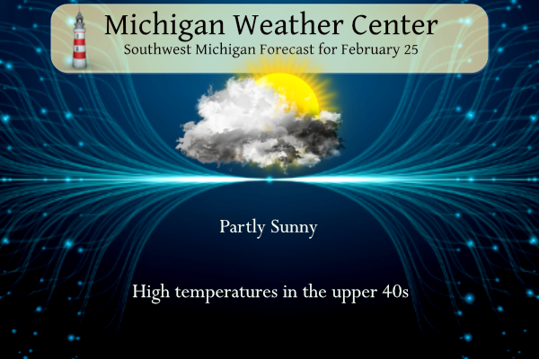
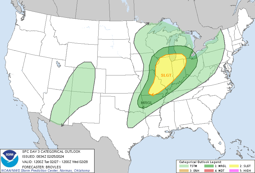
Our high temperature yesterday was 33° with a morning low of 16°. We had a tenth of an inch of snowfall. Today the temperatures will rise to above normal mid-40s with partly sunny skies and windy conditions. In the Tuesday/Wednesday timeframe, we are still looking at a chance for severe storms.
Forecast
Weather History
1957: Mild and rainy weather prevails with lows in the 40s and highs in the 50s. The low of 47 degrees at Grand Rapids sets a record for the warmest low temperature for the date. Over an inch of rain falls as a cold front moves through.
On February 25, 1965, a snowstorm left all of Southeast Michigan covered under nearly a foot of snow. Saginaw received 17.9 inches, Flint had 12.9 inches, and Detroit had 11.0 inches.
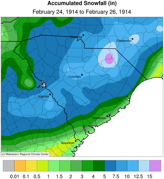
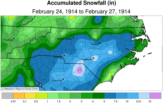
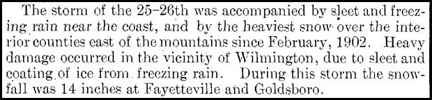
1914: Heavy snow fell over a good portion of South Carolina and North Carolina on February 24-26, 1914. Snowfall amounts include 18 inches near Society Hill, SC, 14 inches in Fayetteville, NC, 13 inches at Darlington, SC, 11.7 inches at Columbia, SC, 8.1 inches at Charlotte, SC, and 7.2 inches at Greensboro, NC, and 7.0 inches at Raleigh, NC.
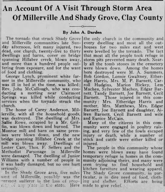
1934: An outbreak of six tornadoes killed nineteen in Mississippi, Alabama, and Georgia. The hardest-hit areas were Bowden, GA, and Shady Grove, AL. An estimated F4 tornado damaged or destroyed 90 homes, many in the Shady Grove community. One home in Lauderdale County, Mississippi, was picked up, thrown 400 feet, and blown to bits. Six family members were killed in the house. Three deaths occurred in two homes, and one preacher was killed during services. Click HERE for more information about the tornadoes in Lauderdale County, Mississippi.
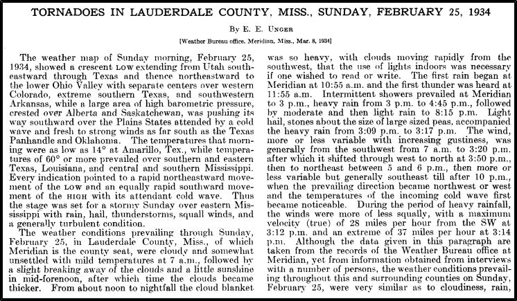
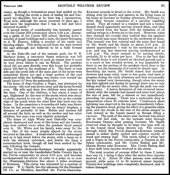
The images above are from the Monthly Weather Review for February 1934.
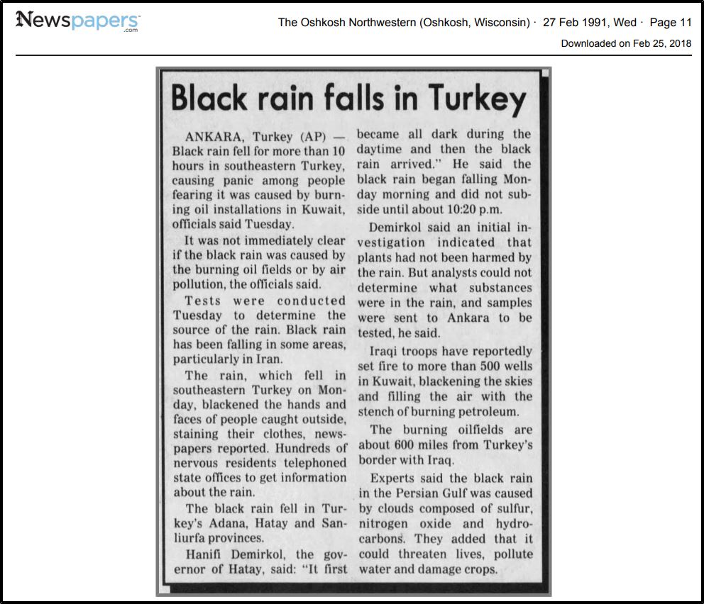
1991: Black rain fell over southeastern Turkey for 10 hours, causing panic among people. The black rain resulted from soot from burning oil fields in Kuwait.
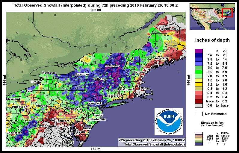
2010: A powerful nor’easter spread significant snow and windy conditions across the Middle Atlantic region from Thursday, February 25 into Friday, February 26. An area of low pressure developed off the Carolina coast late Wednesday night, February 24, and then strengthened as it tracked northward to near Long Island, New York, by Thursday evening. As low pressure aloft deepened over the Mid-Atlantic coast Thursday night into Friday, the surface low retrograded and moved westward into northern New Jersey and southern New York. By February 27, the low pushed into southern New England and gradually weakened over the weekend. Strong wind gusts were measured throughout the Middle Atlantic region due to this coastal storm. Some of the highest wind gusts recorded include 62 mph measured at Cape May, New Jersey; 52 mph at the Atlantic City Marina; 51 mph at the Mount Pocono Airport and Lewes, Delaware; and 50 mph at Dover Air Force Base. In addition, wind gusts of 40 mph or higher were recorded in Philadelphia, Wilmington, and Allentown. Considerable blowing and drifting snow resulted, especially from the Poconos eastward into northern New Jersey. Snow drifts as high as 3 to 5 feet were seen across portions of Warren and Sussex counties in New Jersey. Total accumulations of 20 inches or more were recorded from Morris and Sussex counties in New Jersey, westward into Monroe County, Pennsylvania. In addition, a band of 12 to 18 inches of snow accumulation was measured from Warren and Morris counties in New Jersey westward to Lehigh County, Pennsylvania. In addition to snow that accumulated during the daytime on Thursday, many locations across the region experienced a heavier burst of snow with gusty winds Thursday night into early Friday, thanks to additional moisture wrapped around the low-pressure system. Some areas saw snowfall rates of 1 to 2 inches per hour, mainly from northern New Jersey and into the Poconos. Central Park ended the month with 36.9 inches of snow, making this the snowiest month since records began in 1869.


2017: An EF1 tornado was confirmed in Goshen and Conway County, MA. This tornado was the first-ever recorded in February for M.A. since records began. The graphic below is from a tweet by the N.W.S. Office in Boston, MA.

Forecast Discussion
- Some sunshine today and Monday; warmer

A variably cloudy sky will result in some sunshine today. An
upper trough is passing by to the north and will bring more mid
and high clouds with it today and tonight. Neutral to weak
ridging conditions are expected Monday which should result in a
bit more sunshine than today.

Southwest flow will advect warmer air into the region. We`ll see
highs in the 45-50 degree range and in the upper 40s to near 60
Monday.

- Unseasonably Warm Tuesday

Steady warm air advection occurs into Tuesday so the temperature
will be trending upward during this time.  Values at 925 mb increase
to 12 to 14 deg C Tuesday.  This low level thermal ridge moves east
of the area by Wednesday morning.  Mixing to this level level
supports daytime temperatures in the 60`s.  This is supported by the
ensemble guidance and max temperature values have trended upward
slightly over the past few runs.

- Risk for thunderstorms Monday night into Tuesday night

A low level jet moves into the region Monday night.  This feature
may interact with steeper mid level lapse rates and elevated
instability to generate a few storms.  Guidance does not show much
precipitation around but the models typically struggle with elevated
convection. This lack of precipitation is probably related to the
limited moisture that will be available.  If any storms do occur
Monday night into Tuesday morning hail would be the primary hazard.
We will feature a small risk for storms.

A deep mid level trough approaches from the west Tuesday evening
into Tuesday night.  Large scale ascent will be on the increase as a
result.   At the same time increasing moisture advects in from the
south and PWAT values climb up to around an inch.  Instability
persists, especially in the evening.  All this will support an
increased potential for thunderstorms.  Deep layer shear is shown to
be supportive for organized convection. In general the ensemble CAPE
guidance shows the highest surface based values over southern parts
of the CWA. We will feature categorical POPs for the the CWA.

- Turning Colder Wednesday into Thursday

Models are in good agreement in showing strengthening cold air
advection Wednesday afternoon and continuing into the evening.  The
thermal trough arrives Wednesday night.  Based on ensemble guidance
the temperature values Wednesday night into Thursday will be more
typical for this time of the year.   A chance for some snow exists
Wednesday afternoon and evening as the wrap around moisture tries to
move into the area but overall, the potential any impacts is low as
the ensemble mean 24 hour snow values are all under an inch.  This
cool down will not last though, as warm air advection is shown to
arrive by Thursday afternoon.
Hard to believe it is only February looking at the 10 day forecast, looks more like a 10 day forecast for mid May. Some of the forecast high temps are more than 30 degrees above average! And with storms and thunderstorms moving through we’re probably going to be mowing grass by the end of the week. We actually had to turn the AC on in the restaurant a few days ago because the dining room was up to 81 degrees. Crazy weather.
This is very bizarre for sure. If it was only 5-7 days I would understand… but even 2 weeks out and there is no end in sight to the pattern
We’ve only had three days this month with below average temps. The month may end up +8F or even more.
Breezy today but nice. My son and I just got home from the driving range. There were a good number of people on the range.
This might be the warmest end to February and start to March I remember? We had a warm period in February 2017… but I don’t think it was this long. The question is if the warmth will last through March. The CPC seems to think so… we will see
Eeeee Eeeee blowtorch alert!
With El Niño ending in April, looking like a nice hot summer too!
It has been way too warm this winter! Maybe we will get lucky and have a cold summer! Bring it!
Slim, where are we at for days with snow on the ground? Still on track for a record low year? And is that record for meteorological winter?
The record low for a winter season (October-May) with at least 1″ of snow on the ground is 23 in 1982/83 in 2nd place is 30 in 1931/32 with 30 in 3rd place is 1952/56 with 33. So far this winter season Grand Rapids is at 25.
Slim
Thanks!
The official H/L yesterday was 31/14 even with 95% of the possible sunshine with a low dew point and a cold NE wind it felt much colder that that. For today the average H/L is 37/22. The record high of 61 was set in 1976 the record low of -14 was set in 1950. The wettest was 1.43” in 1926 the most snowfall of 8.1” fell in 1935. The most snow on the ground was 17” in 2014. Last year the H/L was 32/23 and there was 0.7” of snowfall.
Slim
With clear skies the overnight low here in MBY was 25 and at the current time with clear skies it is 27.
Slim