
Yesterday we had 1.53 inches of rainfall in Otsego with over an inch falling in the afternoon. We reached 81° with a morning low of 66°. Today we will have a cooler airmass in place with highs around 70° with chances of rain and maybe a rumble of thunder.
Grand Rapids Forecast
9 7 grrU.S.A and Global Events for September 7th:
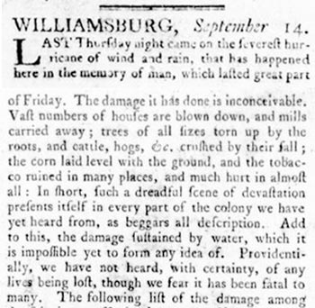
1769: Considered one of the worst storms of the Eighteenth century, this hurricane passed over Williamsburg, Virginia. Click HERE for more information from the Weather Prediction Center.
1970: A lightning bolt struck a group of football players at Gibbs High School in St. Petersburg, FL. The lightning killed two people and injured 22 others. All 38 players and four coaches were knocked off their feet.
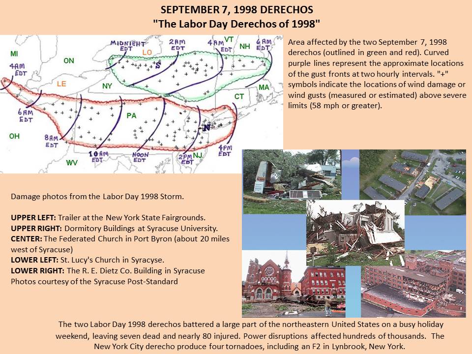
1998: Two Derechos occurred on this day, one affecting most of Pennsylvania and New York City, the other impacting central New York.
Forecast Discussion
--Light showers this morning and afternoon--

The positively tilted upper level trough is slowly moving through
today as the surface low tracks through southern lower Michigan
this morning. The post frontal air mass while cooler, is also
moist with low clouds draped over the region. This stable but
moist air mass will keep drizzle and scattered showers over the
area through this morning and the first half of the afternoon.
 The intermittent showers will end as the surface low tracks
eastward and the drier air from the building high pressure advects
into the area.

--Improving conditions Friday--

 The before mentioned high will build over the region which will
allow winds to slacken and overnight into tomorrow.
 This will also allow for clearing skies and cooling temperatures.
Daytime highs should only reach the upper 60s.

--Cold, clear and mild this weekend--

 The cold air advection, northerly flow and dry air should allow
for lows to be in the low 50s along and south of I 96 and near to
just below 40 along and north of the US 10 corridor Saturday
morning.

 Expect a mild weekend with temperatures rebounding into the mid
70s Saturday and Sunday.

--Chance of precipitation early next week--

Models remain consistent about tracking a system through the
region early next week. That cold front should bring a chance of
showers and perhaps an isolated storm Monday into Tuesday, though
there is some questions on timing. Similar to the current low
moving through, a cool airmass will advect in behind and will
further advance our march into autumn. Prepare for temperatures to
fall Tuesday through Thursday when high temps will struggle to
get out of the 60s and lows mainly in the 40`s to low 50s.
Great temps today and for the next 2 weeks! Incredible!
Mid level troughing as well as low level moist cyclonic flow and H8 thermal troughing will act to keep extensive cloud cover and isolated showers in place through Friday. Eventually a push of drier air coming down from the north should bring some clearing to the U.S. 10 corridor by late in the day Friday and to the rest of area on Friday night. The clouds will limit diurnal temp variation with lows tonight in the mid to upr 50s and highs on Friday in the mid to upper 60s. However the clearing on Friday night may yield some rather… Read more »
There are winter storm warnings for Northern Alaska (Brooks Range Mtns) for 8” of snow above 4,000 feet. A sign that winter is beginning its slow decent southward. I have a trip planned to visit Alaska in the spring. Might even drive the Dalton Hwy to the Arctic Ocean. Should be a fun time.
The official H/L yesterday at Grand Rapids was 82/68. The official rain fall amount was 0.16” Here in MBY I recorded 0.32” of rain fall. The highest wind speed of 35 MPH was out of the SW. There was 25% of possible sunshine. For today the average H/L is now down to 77/56 the record high of 96 was set in 1960 and the record low of 38 was set in 1986. The record rain fall of 1.64” fell in 1987. Last year the H/L was 79/56.
Slim
The week ahead looks to be more early fall like than what we have been seeing this weekend is summed up in todays NWS discussion as -COLD, CLEAR AND MILD THIS WEEKEND– After a brief warm up this weekend it will turn cooler again and highs will range from the 60’s today and tomorrow and then the mid to upper 70’s before falling back into the 60’s again. Lows will be in the 50’s to upper 40’s.
Slim
We are finally transitioning into a *very* early fall pattern. I know “favorite weather” is opinion, but 60s and 70s are my favorite for sure. Comfortably warm and great for outdoor activities
A period of “don’t have to” that is don’t have to have the heat on and don’t have to have the air on. Enjoy having the windows open.
Slim
Yes!!! I love when we can save a little money not running those big items.