First – congrats to the Wolverines for wrapping up the Big Ten title last night. Sorry, not weather-related but I am a Wolverine fan.
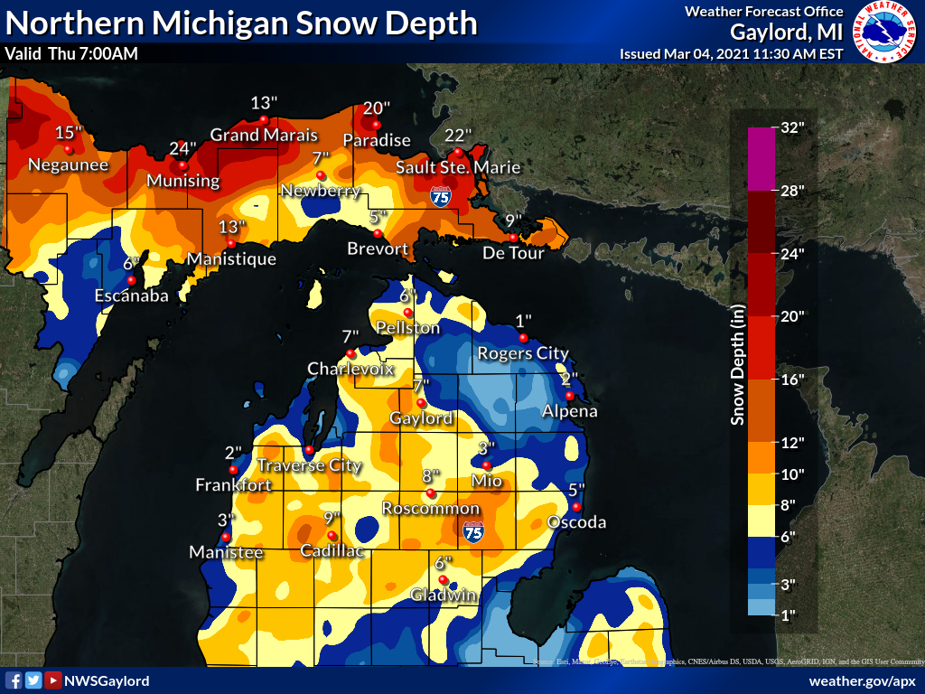
This snow depth map is a satellite estimate of snow depth over the area. It may not reflect current actual conditions until skies are clear enough for a good satellite image.
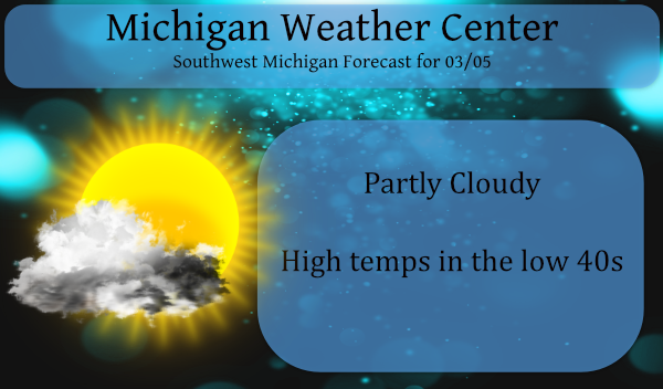
With the exception of a few lingering snow piles areas south of I96 have lost most of the snowpack. We should see most of the remnants melt away over the next few days.
We should be able to enjoy lots of sunshine over the weekend right on until Thursday of next week when our high-pressure systems move out the jet moves closer to the midwest bringing us a more unsettled weather pattern.
Forecast Discussion
-- Dry weather expected to continue through early next week --

Relative humidity BUFKIT overviews tell the story well over the
course of the next few days with limited moisture to work with. We
are mainly dry from 5000ft on up through the profile, so
precipitation is not a concern today or through Monday for that
matter. We are hanging on to air that is just cold enough for lake
generated stratocumulus and that will be a player in the sky
forecast both today and Saturday. The relative humidity progs in
the 925-850mb layer show a diurnal component to the moisture as
well, with moisture increasing in that layer each afternoon. It is
the time of year where we start to see the chance for diurnal
cumulus development. So, each afternoon, today and tomorrow could
see partly cloudy conditions as lake stratocumulus drifts in on
northerly flow. Diurnal cumulus scheme also supports some clouds
both days.

Deeper moisture does not really show up in the profiles until we
get later into Tuesday, so high confidence in dry weather through
that time. Surface ridging will dominate through that time.
Southerly flow begins to take hold as we head through Monday and
Tuesday.

-- Readings near normal through weekend then warmer next week --

We continue to hang on to 850mb temperatures in the -6C to -8C
range today through Saturday night. Warming of the lower
troposphere really starts on Sunday as we warm above 0C. So
through the weekend we are expecting to remain near normal in
terms of highs and lows with lows in the teens and 20s and highs
up around 40.

Model indications, both MOS and ensemble output, have been pretty
consistent in showing at least southern portions of our area
making a run at 60F on Tuesday and Wednesday of next week. We will
likely be in the 50s on Monday with Tuesday potentially being the
warmest day. The operational ECWMF has 60+ readings over the bulk
of our area Tuesday, the exception being the northwest CWA with a
wind off the water up there. Even on Wednesday and Thursday with
rain it will feel warm (50s) compared to where we were for the
bulk of February.

-- Details a bit fuzzy yet but expecting rain mid next week--

The models still have a bit of spread in how the pattern evolves
mid to late next week in terms of surface synoptic features. The
GFS still remains a bit quicker with a low and front moving
through the area, with the ECMWF being slower. The GFS also brings
the front back into the area for another swath of rain into
Thursday.

The bottom line though is we will see deep southerly flow in place
with the threat of some heavier rain. The new GFS is even
indicating the potential for 2+ inches of rain in spots. PWAT
values increase to in excess of an inch, 850mb dew points rise to
around +9C, 850mb LI`s dip to -1C in a zone of strong moisture
advection on a low level jet that will be near 50 knots. All that
to say there are solid indications for a soaking heavier rain,
not to mention the threat of some embedded thunderstorms given the
dew point values and LIs.

Regarding hydro concerns, the snowpack has largely been eroded
from I-96 to the south. Snow remains in place for areas across
Central Lower Michigan. River ice is largely gone with the
exception of areas behind dams, which is not a concern obviously
in regard to ice jams. The snowpack across Central Lower will
continue to be eroded by the sun and warm temps in next week. So,
while the threat exists for some heavier rains, we have at least
cleared out of the way most of the river ice and snow. Snow melt
has resulted in within bank rises so it is not out of the
question to see some rivers next week exceed bankfull resulting in
some minor flooding. We will continue to monitor and provide
updates as we head through next week. At this point though not
expecting major issues.
Looks like snow is done, took off all the plows this week!! Left the salt truck loaded just in case!!! Let’s get mowing!!!
Around March 15 or 16 the GFS model shows a pretty good snowstorm over Michigan yes snowstorm followed by some below normal temps wouldn’t surprise me if the rest of March is on the colder side of things! Go Blue!! INDY
Who would have thought! Bring it!
Am I not able to post? Not sure what’s going on? I see lots of 50’s and even some 60’s upcoming. I love it!
Michigan looks really, really good this year. I will be rooting for them to take the whole thing.
So much sunshine lately. I love it!
Great news, there is still plenty of snow and cold up North! I just made plans for more skiing up in Snow country! What an incredible and awesome trip! Who wouldn’t love snow and skiing this time of year?
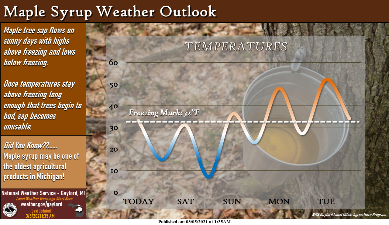
When I was out for my walk yesterday I was hit by some sap falling from several Maple trees so yes the sap in running here in west Michigan. The overnight low here at my house was a crisp 18 it looks like the official low at GRR will be 20. At this time it is clear here with a temperature of 21. While most of the snow is gone is the sunny locations there is still a lot of snow in the woods and of course there are still good sized snow piles.
Slim