I can’t remember when we have had so much sun this early in the late winter/early spring – high pressure has pretty much blocked any moisture from coming into the state over the past week. We have essentially lost all of our snow cover with the exception of a few piles here and there. We have at least three more days of sunny skies and warming temps before the jet stream pushes closer to the state allowing a change in the weather pattern. Temps will warm into the 50s and low 60s beginning tomorrow. We may hear our first rumbles of thunder Wednesday and Thursday.
We will warm into the upper 30s to mid-40s today. Much warmer conditions are expected for the first half of the workweek. Temperatures should peak on Tuesday, with areas near and south of I-96 reaching about 60 degrees. Rain and gust winds are expected late Wednesday into Thursday.
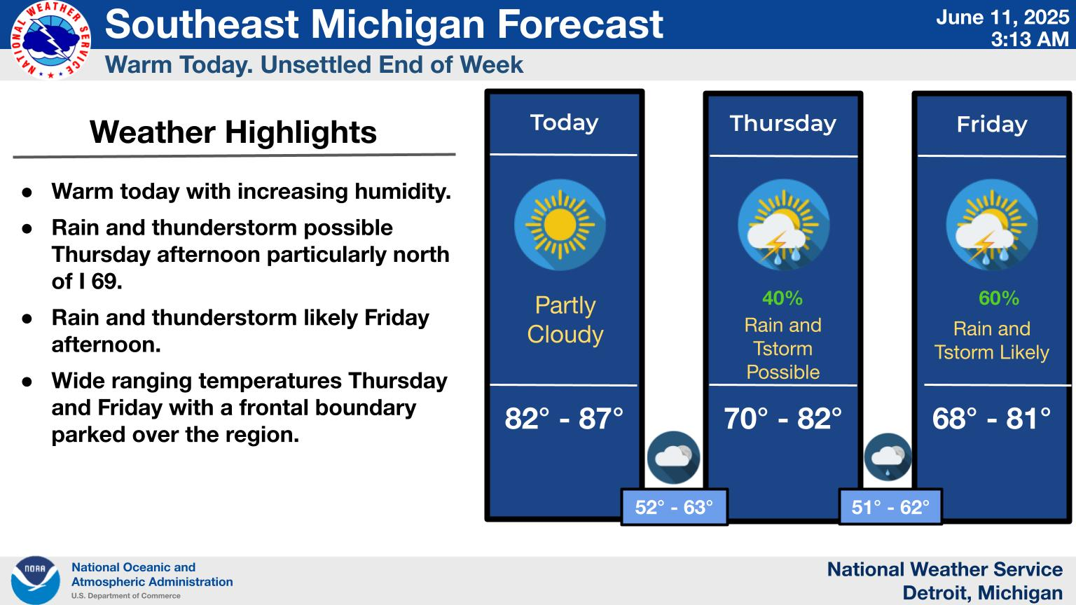
For those of you who don’t look at the main page here, there are additions to the tabbed app and of course, there are the point forecasts below that for most of the larger cities in the state.
- Interactive Radar
- Planner
- Grand Rapids
- Marquette
- Gaylord
- Detroit
- National
- QPF


Forecast Discussion
-- Warming trend and mostly dry through mid week --

High pressure over Michigan will provide plenty of sunshine
today. Latest IR loop shows high clouds over the northern Plains
and some of these clouds will spill over into Michigan this
afternoon. We`ll see quite a bit of sunshine today through
Tuesday, and as the ridge moves east, south flow will increase and
temperatures will rise each day through Tuesday. Tuesday will end
up being the warmest day and widespread 60 degree temperatures
will be found across the southern CWA and upper 50s across the
north. Clouds will be on the increase Tuesday night and Wednesday
as low pressure over the southern Plains moves northeast along a
frontal boundary.

-- Wet toward the end of the week --

As the Gulf opens up, moisture will stream north and interact
with several short waves moving through the southwest flow and
showers will develop, perhaps as early as late Tuesday, but more
than likely by Wednesday. Instability doesn`t look high enough for
thunder at this point.

The best chance of rain looks to be late Wednesday night and
Thursday as the low moves by and drags a cold front through the
state. Confidence is pretty high that we`ll see some rain during
this time, but how much is the question. The 00z model runs show a
little higher QPF across the southern CWA vs yesterday`s runs,
but it doesn`t last long as the front pushes south and takes the
rain with it. The main question is whether the front will hang up
over the southern part of the state or move south into Indiana.
Both the GFS and ECMWF push the frontal boundary south into
Indiana. In fact, the ECMWF pushes it south of the Ohio River. The
ECMWF ensemble mean is around 0.75 inches, which is similar to
both the GFS and Canadian ensembles. At this point, this doesn`t
appear to be a flooding situation, but it`s still several days
away and we`ll keep watching it.
Checking out the GFS this morning yes it’s a weather model gives the great lakes a few chances of snow starting around the 14th or so we easy could end the end of of March on the cool side stay tuned….INDY…
As always “Beware of the Ides of March”
Slim
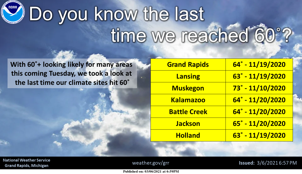
With 6 days in the record books March 2021 is just about average temperature wise. Here at Grand Rapids the current mean is 31.3 and that is +0.2. So far the average H/L is 41.0/21.7 the current 30 year average is 39.0/21.7 so the days have been warmer than average but the lows have been colder than average. There has been just a trace of rain/snow. And the seasonal total remains at 42.8” and that is -21.3” At Muskegon the mean there so far 30.0 and that is a departure of -0.9 the H/L there has been 39.8/20.2 and there… Read more »
Down to 14* degrees overnight in my area pretty cold for almost mid March standers keeping lots of snow piles around my yard going strong ..INDY
The low here was 13.6. But the official low at GRR was 17.
Slim
Wow, those are some crazy low snow totals for the season! Muskegon almost 4 feet below average and growing by the day yet?? As for the “mid March standers” when it’s actually the first week of March, 17 degrees is not that far off from normal when the average low is 24 and the record for today is -3. However forecasts for upper 50’s and 60 degrees when the average high is only 40 is quite a ways from our early March “standers”.
I love early spring Thunderstorms!!! These front loaded springs are the best!! Keep this gorgeous weather going!!
I agree MV. This is not usually the time of the year when you get 2 weeks straight of clear and sunny skies, but it is awesome! This would be the perfect weather year around, dry, sunny, and temps around 50 to 60 degrees.