
We have definitely moved out of our dry weather pattern having tapped into a good supply of moisture from the Gulf of Mexico and a slow-moving meandering frontal boundary. Chances of rain are 100% today with rainfall amounts in the two to three-inch range. We have had 1.12 inches thus far from this event in Otsego which has brought us up to 5.24 inches for the month.
[columns] [span6]
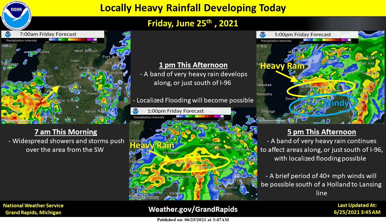
Showers and storms will become more widespread this morning. Locally heavy rainfall will become likely by afternoon, with the best chance of heavy rain along I-96 or just south. Locally heavy rainfall will continue into early this evening. Strong winds of 40+ mph will become possible along and south of a Holland to Lansing line late this afternoon.
[/span6][span6]
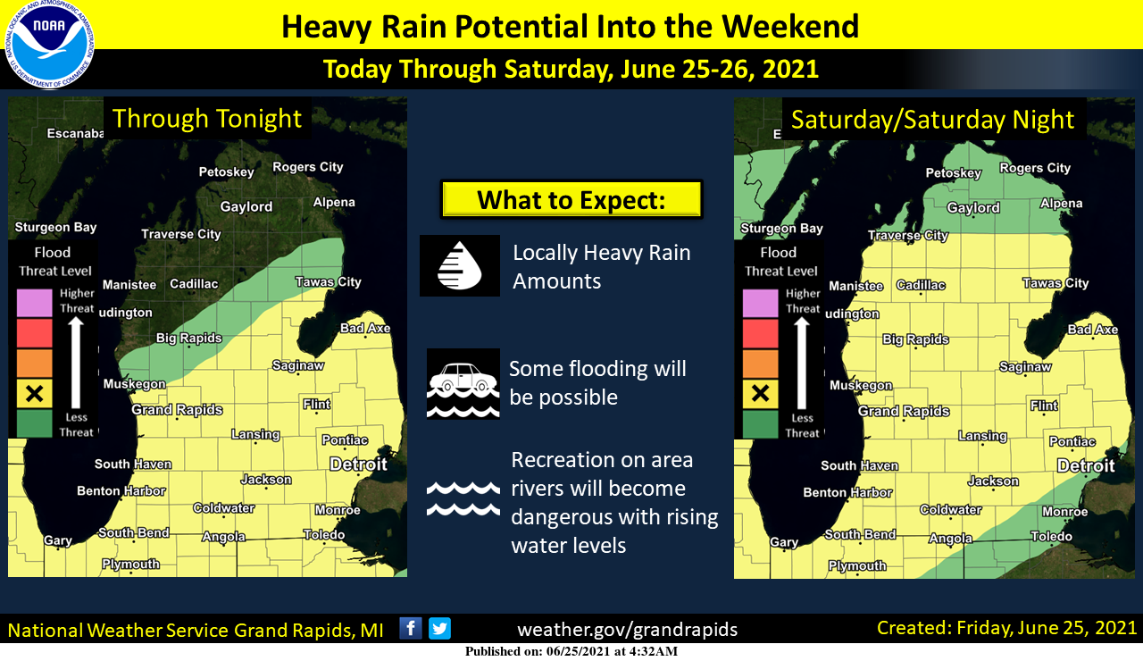
Heavy rain will be likely both today and tomorrow, with localized flooding possible. Urban and low lying areas will have the best chance of some flooding. Rivers and streams will become more dangerous for recreation as levels rise with all of the rainfall.
[/span6][/columns]
Forecast Discussion
- Flooding risk continues into next week

Very unsusual pattern evolving for the region and the concern for
impactful flooding is on the rise. Mid to upper level trough sets
up over the central to upper plains today and stays there into
next week. Off to the east a mid to upper level high sets up over
the mid atlantic and helps to funnel abundant moisture from the
Atlantic and Gulf through the Great Lakes Region through much of
the period. Multiple mid level waves are shown to form/get caught
up in this flow and will act to tap this moisture leading to
several periods of heavy rain. One mcv upstream crossing the MS
river in southeast IA at this time is shown to track through
southern Lower MI today. PWATs climb up to around 2 inches and
rain will be heavy at times. A high risk for 2 to 4 inches exists
just through tonight.

Several more waves are shown to push in Saturday into Sunday
morning...each of which could result in additional rounds of heavy
rain. How much of an impact this results in will likely be
determined by whether they repeat over the same area. Still...with
each of these waves capable of producing periods of heavy rain
with rain rates topping an inch per hour...urban and poor drainage
flooding could become an issue especially where any cells train
for a couple of hours.

Jumping ahead to the middle of next week and the trough is still
there off to our west based on most models. The duration of this
event is concerning.


- Potential for severe weather

Deep layer shear periodically ramps up as each mid level wave
goes by through the weekend. Daytime heating could lead to some
decent instability...especially Saturday. Low level helicity
values are certainly elevated as well...and all this rain is
leading to saturated soil conditions. This could act to lower the
lcl`s. Thus...an increased risk for a few tornadoes could
develop...in addition to a wind risk.

- Possible wake low this afternoon

Speaking of the wind...it is interesting to see most of the
models showing a strong signal for a wake low towards noon into
the afternoon. The area along and south of a Grand Rapids to
Lansing line looks to be at the highest risk for this to happen.
We will add this risk to the HWO...bump up winds in the grids and
mention the potential in social media posts. If this feature does
get going...we may need to consider a wind advisory for a few
hours..
Hydrologic Discussion

...Rounds of Heavy Rain Expected This Afternoon through the
Weekend...

Rounds of heavy rain have begun across Lower Michigan, and will
continue through early next week. All rivers will see significantly
rising water levels. Flooding on some of our rivers is possible as
early as this weekend. The best estimates are that 2-4 inches of
rain will fall across a wide area in Lower Michigan. Because these
rounds of rain will include thunderstorms, local rain totals of 5
inches or more are likely by the end of the weekend. This not only
will send plenty of water into the rivers, but also has the
potential to cause issues with ponded water at low spots, on roads,
and in other poor drainage areas.

Drivers need to exercise extra caution this weekend, especially at
night, as ponded water on roads is very difficult to see in the
dark. In addition, anyone living or recreating along any of the
rivers in Southwest Michigan should prepare now for rising water
levels. Secure outdoor furniture, small boats, and other items that
may have been left near the riverbanks so far this summer.
Batten down the hatches! Sirens going off. We’re at the local middle school for daughters recital. Fingers crossed for no tornado!
1.3″ April. .87″ May. I’ll take the rain.
More rain towards 1-3AM and after, and a chance of storms tomorrow 2PM-10PM. Definitely an exciting weather pattern… but I wouldn’t mind 80 and sun again 😀
It actually feels nice out.
THE SUN IS OUT!!!
2.97″ so far when it started yesterday.
That is some thick air today. Temps may be in the 70’s, but with the dew point at 73 it feels gross. Need the ac on just to dry out the air.
Feels tropical.
Currently 68* degrees and more rain in my rain in my area loving this weather …Great day to kick back with a cold Sprite…INDY
This is far too much rain…starting to be a drainage hassle
I have now gone over the 1 inch mark since 7AM and over 2.30″ for yesterday and today. At this time it is still raining here with a temperature of 71 and a DP of 70.
Slim
It sure is raining a lot! Definitely a crazy change from the weather pattern from the first 3 weeks of the month. Normally this time of year I imagine sun, humidity, and highs in the 80s. I am sure that weather pattern will return eventually, but until then, this rain is going to really end most of the drought.
Since 7 AM I have recorded an additional 0.63″ of rain fall for a total of 1.93 for yesterday and today so far. At the current time the temperature here and at the airport is 70 the DP here is 69 and the last reading at the airport was 70.
Slim
ADA – 1.10 inches for Thursday. On a side note, large, dead trees/branches tend to “absorb” rainfall, especially rainfall over a long period of time. Trees/branches become very heavy, and collapse without wind, or warning. I’ve had it happen several times, and am expecting more this week. Just a heads up 😉
1.08 in recorded this morning but within an hour of recording that I am up to 0.78 already for today. When it rains it pours!
MSU weather station in Grand Junction recorded 1.09 yesterday and .95 so far today. Raining now.
I just heard my sump pump kick on for the first time this year.
very heavy rain falling here now temperature is at 67.
Slim
What more rain and temps in the 60’s wait a minute where is all the heat that supposed to be here asking a friend?? Lol..Let’s be true here the drought is over for all of west Michigan build a boat your going to need one ….Have a nice Friday …INDY
This is horrendous weather! Give me a snowstorm over this absolute mess any Day!
Yeah I think I would agree. This is not going to be good.
“ The duration of this event is concerning.”
This statement stood out to me. You usually do not hear emotion in the forecast discussions.
My rain fall for yesterday and overnight is now at 1.30″ The total at the air port so far looks to be 1.19″ for yesterday and 0.03 overnight. The overnight low here was 64 and 66 at the airport. At this time it is 67 both here and at the airport. I have light rain falling and the report at the airport was heavy rain falling. Here is some thing that is very interesting even if it dose not happen. ” POSSIBLE WAKE LOW THIS AFTERNOON SPEAKING OF THE WIND…IT IS INTERESTING TO SEE MOST OF THE MODELS SHOWING A… Read more »
Slim, could you explain a wake low? Or anyone?
https://en.wikipedia.org/wiki/Wake_low
It’s a bit technical, but it may help.
Thanks Mark….
Thanks Mark!!!
I remember this event well from bills blog, it was the first time I heard the term. Surprised they have an entire page dedicated to this event:
https://www.weather.gov/lot/2011jun15_wakelow
Thanks Nathan… Great info with pix…