Yesterday we had .13 of an inch of rain which brings our June total to 4.12 inches for the month in Otsego most of it registered over the past seven days. This past week we have almost doubled the rainfall we had all of this past spring.
At 4:30 am we have partly cloudy skies and a temp of 61°.
We have an extended period of rain expected. This is the latest hydrologic outlook from the NWS:
Several days of heavy rainfall will move into Lower Michigan
beginning Thursday night and continue through early next week. All
rivers will see significantly rising water levels, and flooding on
some of our rivers is possible as early as this weekend. The good
news is that the Grand and Muskegon river basins are starting out at
extremely low levels due to the ongoing drought. The Kalamazoo River
basin has had more rain in the last week, and so is starting out at
a level closer to normal for this time of year. At this time the
best estimates suggest 2-4 inches or more of rain are possible
across most of Southwest and West-Central Michigan. Thankfully this
rain will come in multiple rounds spanning several days, rather than
all in one shot. This will help the rivers pass the water hopefully
without getting to the point of overflowing (flooding).

The second area of concern is for more of our typical ponding of
water on roads, low-spots, and poor drainage areas. There will be
several batches of thunderstorms moving through Michigan, and with
humidity levels surging back up to where they were last week, we are
expecting some places to see torrential downpours at times. As
usual, this will probably primarily affect drivers and road
conditions, so be alert for ponded water and possible flooded roads
after one of these heavy thunderstorms passes through.
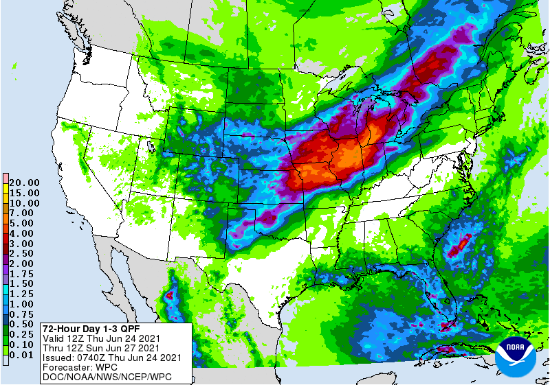
I would say this will be a drought buster as we go from one extreme to another. There are rain chances right on through the next seven days. Below is the QPF (Quantitative Precipitation Forecasts) over the next 72 hours suggesting three to five inches of rain.
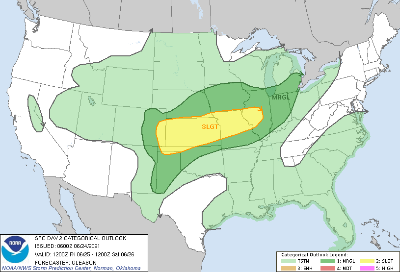
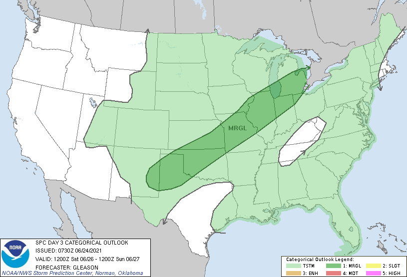
Below is the SPC outlook for Friday and Saturday which places southern Michigan in the marginal risk for severe weather:
[columns] [span6]
[/span6][span6]
[/span6][/columns]
Forecast Discussion
Moisture return continues today in southwest flow regime.
Shortwave trough across southern Canada is flattening as it moves
east and area of showers and thunderstorms currently across
northern Minnesota will move southeast and should reach western
Lower Michigan late this morning. Thunder/severe threat is
limited by shallow, elevated instability and less than 25 knots of
deep layer shear. Main threat will be isolated wind gusts.

Deep moisture continues to advect in ahead of the surface front
tonight as low level jet and convergence increases and
precipitable water values spike up to near 2 inches. Wave of low
pressure rides along the front across Lower Michigan on Friday
morning and area of heavy rain with embedded convection is
expected to attend the passage of this feature.

There could be a break in the heavy rain Friday evening, then
another perhaps stronger sfc low moves along the front late Friday
night into Saturday with another batch of heavy rain. The sfc
front is expected to move southeast of Lower Michigan on Sunday
in the wake of the low passage. There is uncertainty on how long
it takes to return north as a warm front, but eventually it does
and more heavy rain becomes possible later in the week.
Very interesting write up this morning:
https://forecast.weather.gov/product.php?site=GRR&issuedby=GRR&product=AFD&format=CI&version=1&glossary=1
I now have over 1.00″ of rain fall today.
Slim
Elem on wood tv 8 just said some models are showing 8+ inches of rain by next weekend that’s crazy the Grand river will be flooding if that happens yup the heat is gone and so is the drought …INDY
Don’t park in the Ionia fairgrounds.
Slim
Yes!! Slim could you imagine if this was all snow wow ….INDY
Holly cow 64* degrees and heavy rain fallen in my area nice Summer day hu mookiee??? INDY
Up to 1.01″ so far in the last couple hours and still coming down.
0.29″ of rain fall here so far. The high today looks to be just 74 so another day of below average temperatures. At this time it is cloudy with some light rain falling and 64 with a cool wind.
Slim
Could it be May and June below average wow …INDY
Well, getting close to an inch already here. 4 more to go??
It is raining pretty good here.
Whoa, bye bye drought: Hydrologic Outlook National Weather Service Grand Rapids MI 1252 PM EDT Thu Jun 24 2021 …Rounds of Heavy Rain Expected This Afternoon through the Weekend… Rounds of heavy rain have begun across Lower Michigan, and will continue through early next week. All rivers will see significantly rising water levels. Flooding on some of our rivers is possible as early as this weekend. The best estimates are that 2-4 inches of rain will fall across a wide area in Lower Michigan. Because these rounds of rain will include thunderstorms, local rain totals of 5 inches or more… Read more »
So….maybe we get wet…again
That is a crazy looking rain map. 5 inches? From one extreme to the other is right. We’ve rarely had 5 inches of snowfall at a time over the past several years let alone 5 inches of rain.
I agree, that rain map is crazy and I hope it does not happen! I would be happy with an inch of rain! Incredible!
I hope we get pummeled with tons of rain!! BRING IT!!
I hope we get absolutely hammered and pummeled and plastered with cold and snow this winter! That would be Awesome baby!
Wow several inches of rain coming temps in the mid 70’s so much for a hot start of Summer shuuuu everyday now days are getting shortter and we are one day closer to September does it get any better then this ??? Hail No …Enjoy the cool wet weather ..INDY
Here at my house I had 0.02″ of rain yesterday evening. Officially at GRR they reported 0.09″ of rain fall. The official overnight low at GRR looks to have been 61 the low here at my house was 62 The latest reading from GRR is 64 here at my house I have 63. Grand Rapids has now had 3 days in a row with mean departures of more than 10° below average. Less than a week ago Grand Rapids was on track for one of the warmest June’s on record now that is no longer the case and GRR is… Read more »
So basically June will go out below average now wow ….Let’s keep it going through July ..INDY
Yes just another of many below normal temp months! Incredible!