
The warm mid-fall continues today which has been a good thing for the drying of corn and soybeans out in the fields as harvest time comes closer. On the other side, the gardens are also winding down. I still have a bunch of tomatoes green peppers and onions I am picking daily, especially my cherry tomatoes which did very well this year. I will miss the fresh tomatoes when they run out, they are much tastier than store-bought hothouse tomatoes.
Enjoy the summer-like weather while it’s here. Expect mostly sunny skies today with highs in the upper 70s to mid 80s. Clouds increase tomorrow with an approaching cold front. Temperatures should still get into the upper 70s to 80s before rain moves in late Wednesday afternoon and continues overnight. Cooler temperatures and showers are then expected for the remainder of the week.
SW Michigan Forecast
U.S.A and Global Events for October 3rd:
1780: A hurricane, which formed on October 1st, destroyed the port city of Savanna-la-Mar on the island of Jamaica on this day. By some estimates, this storm caused 3,000 deaths. This storm is documented in the Jamaica Archives and Record Department. Click HERE for more information, including a Petition to the Governor requesting instant relief. For additional information on the deadly hurricane season of 1780, see this website from the History Channel.
1903: An unusual late-season tornado moved northeast from west of Chatfield, Minnesota, passing through and devastating St. Charles, Minnesota. Seven people were killed, and 30 injured as 50 homes and businesses were damaged or destroyed.


The images above are courtesy of GenDisasters.com.
1979: An F4 tornado struck the towns of Windsor, Windsor Locks, and Suffield in Connecticut, causing an estimated $400 million in property damage, on this day. The New England Air Museum, which housed more than 20 vintage aircraft, was destroyed. This tornado also caused a United Airlines flight to abort a landing at the Bradley International Airport because the pilot saw the tornado. Click HERE for pictures of the damage at the New England Air Museum courtesy from the Hartford Courant.
 The newspaper article was from the Spokane Daily Chronicle on October 5, 1979.
2002: Hurricane Lili made landfall between White Lake and Vermilion Bay, Louisiana as a Category 1 storm. Click HERE for more information from the Hurricane Research Division.
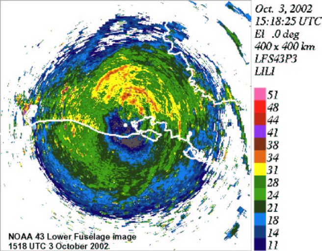
Lower Fuselage radar from NOAA43 of Hurricane Lili’s eye making landfall.
2015: Unprecedented rainfall fell throughout South Carolina from October 1st — 5th, 2015. Storm total amounts greater than 20″ were observed in Columbia and Sumter.
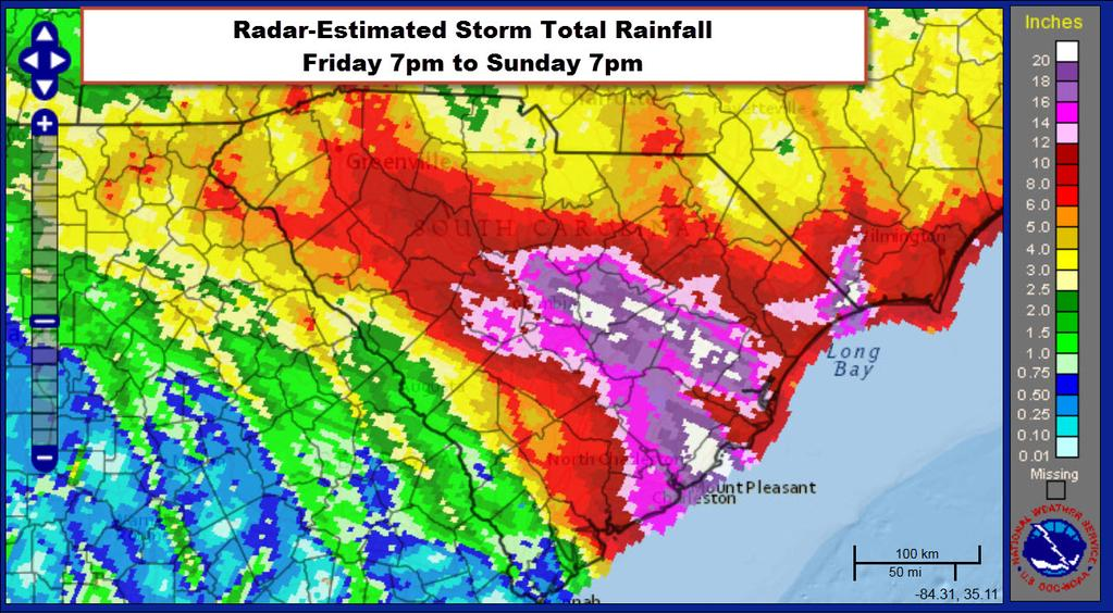
The image above is from an ArcGIS story map from the NWS Office in Columbia, South Carolina.
2017: The City of Houston had the wettest year on record with 73.51 inches. The previous wettest year was 1900 when 72.86 inches were measured.
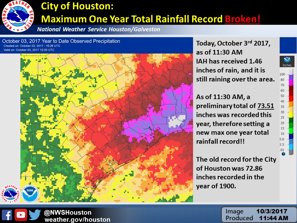
The image above is from a tweet by the NWS Office in Houston, Texas.
Forecast Discussion
Summer continues...at least for the next two days. Looking at the
latest IR loop you`d be hard pressed to find a cloud overhead, but
there are storms over the Plains and some of that cirrus is
beginning to move east.

Sunny skies are expected today thanks to the upper ridge. We`ll
get close to, if not exceed, a record or two again today; see the
Climate section below. Highs in the mid 80s with dewpoints in the
lower 60s will make for summer-like weather.

Mostly clear/partly cloudy skies are expected tonight. Overnight
lows in the lower 60s will only be a few degrees away from normal
highs in the mid 60s...so certainly mild for this time of year.

A strong cold front will begin to push across the lake Wednesday.
Instability is meager ahead of the front though, so just some
showers are expected over the northwest cwa Wednesday afternoon.
Elsewhere, we`ll see increasing cloudiness which should help to
temper the temperatures. The eastern cwa may the exception,
though, and highs there will reach the mid to perhaps upper 80s
which will be near records.

Chances for rain increase (70-80%) Wednesday night into Thursday
morning with the advancing upper level trough. Decent low level
frontogenesis, positive vorticity advection, and upper level
divergence will provide a supportive environment for precipitation.
Precipitable water values are expected to be around 1.5 inches which
is well above the sounding climatology as show on the SPC site for
Gaylord and Detroit. Moist soundings along with a couple hundred
J/kg of CAPE will result in the potential for heavy downpours along
with a few rumbles of thunder. Most are expected to see around a
half an inch to an inch of rain with isolated higher amounts
possible. The flooding threat is low at this time, but known trouble
spots could have some issues.

As the upper level low gradually works through the Great Lakes
Region, showers will remain possible off an on into the weekend.
Thursday and Friday afternoon diurnal showers seem more likely with
the low level lapse rates and colder air aloft. As we head into
Friday evening and through the weekend we run more into lake effect
rain showers. 850mb temperatures below 0C, lake surface
temperatures around 18-20C and northwesterly winds providing a
decent fetch off the lake will be a nice set up for continued
showers through the weekend.

Looking at temperatures, we cool down with all this rain. Thursday
will be the warmest with highs in the upper 60s, but after Thursday
highs will mainly be in the 50s with lows dropping into the mid 30s
to 40s. Fall is finally on the way.
I have used my AC less this summer than in the past 10:years! What a summer!
The NWS shows GR with lows in the 30’s for three straight nights starting this weekend! Who knew? Incredible!
WHAT?!?!?? A record high in GR today?!??! How’s that possible with all the cold weather hype on here! Keep the warmness Rocking!! I’ve had the AC running since April! WHEW!!!
For the second day in a row new record highs have been set at Houghton 86, Marquette 82,and Sault Ste Marie 82 in the UP Alpena 86 and today Grand Rapids 86. At this very warm start to October 2023 continues.
Slim
I love below normal temp summers just like the one this year! Wow!!!
I love long summers! Wow!
I suppose instead of sizzlin seashells we need to make a new one since we are now in fall
Sizzlin pumpkins! seems more appropriate. If it gets any hotter just carve your pumpkin open and enjoy roasted pumpkin seeds 😂 let the good times roll!
It’s now up to 87 degrees at my house. As bill would say…Sizzlin seashells!
86 here, and with the dew point in the 60’s you’re right, it feels like July out. Our AC was turned on back in mid April with the record breaking heat we had, and it’s still running now in October.
Wow! Yeah this is crazy heat for October!
I have 87 here in MBY. Th AC has not turned on yet. I open the windows late last night to let the house cool down and then close them at 7 AM that keeps the house cool for most if not all of the day. An old trick we used in Alpena from years ago.
Slim
Great sleeping weather. 🙂
84 degrees at my house currently. And it’s only a little after the noon hour…on October 3rd. Crazy! You would think it’s July 3!
Enjoy the brief cool down and rain this weekend and then get ready for a BIG change! Sun, pleasant temps and nice weather are coming as we revert right back to above normal temps next week! Highs in the upper 60’s and low 70’s!! Wow, just wow, WOW! Incredible!
If we avoid any lows in the 30s (especially southern 2/3 of the area) I’m thinking the leaf color might last well past October 20th this year
I agree!
What above normal temps again today?? INCREDIBLE!! Keep it ROLLIN!!
Overheard someone say we’re having an “Indian Summer”. We haven’t even had a frost yet so I would just call this an “extended Summer”.
Agreed.
Enjoy today and then get ready for a BIG change! Clouds, rain, wind and cold are coming as we revert right back to below normal temps! Lows in the 30’s! Wow, just wow, WOW! Incredible!
No 30s in the forecast as per WOOD or NWS GR. Soon, my friend. Soon.
There were several record highs set yesterday mostly in the UP and norther Lower Michigan. Records set were 83 at Muskegon, 85 at Alpena, 87 at Marquette and 83 at Sault Ste Marie. The 83 at the Sault is also a record high for the month of October and that 87 ties the record at Marquette.
Slim
Yesterday was indeed a very warm October day. The official H/L at Grand Rapids was 85/47 that 85 is the new 2nd warmest ever on any October 2nd There was no rain fall and 100% of possible sunshine. The overnight low here in MBY this morning is 55. For today the average H/L is 67/47 the record high of 85 was set in 1900,1919 and 1953 the record low of 23 was set in 1974 the most rain fall was 3.59” in 1954. Last year the H/L was 68/34.
Slim
I’m enjoying this uncharacteristically warm weather but c’mon, it’s October. I’m looking forward to the 50s this weekend. It’s hoodie time!
If I had my way it would be like this all year long. But then we would no longer be living in Michigan.
Slim
I have mixed feelings. I really enjoy the summer, but I also love fall/Halloween and the holidays. Once we get past New Years… then I’m usually ready for warmer weather again