Well, if April showers bring May flowers we are off to a good start. We had .24 of an inch of rain yesterday and .19 from April 1st. This time of year most are pining for warmer temps with seed catalogs in hand we scope out what we would like to plant this year. I already have my spring projects planned and am waiting impatiently for the weather to cooperate.
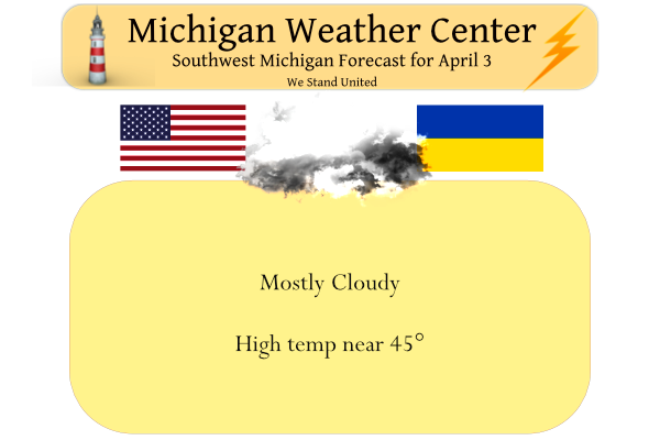
Yesterday we had a high of 44.5° and a low of 23° with a peek or two of the sun early. We will continue to see an active weather pattern through most of this week. It will be mostly cloudy today, then a storm system will track just south of Michigan Monday. That brings a mix of rain and snow in the morning, then just rain into the afternoon. Some snow accumulations are possible north of I-96 Monday morning. A system on Wednesday brings more rain and warmer temperatures.
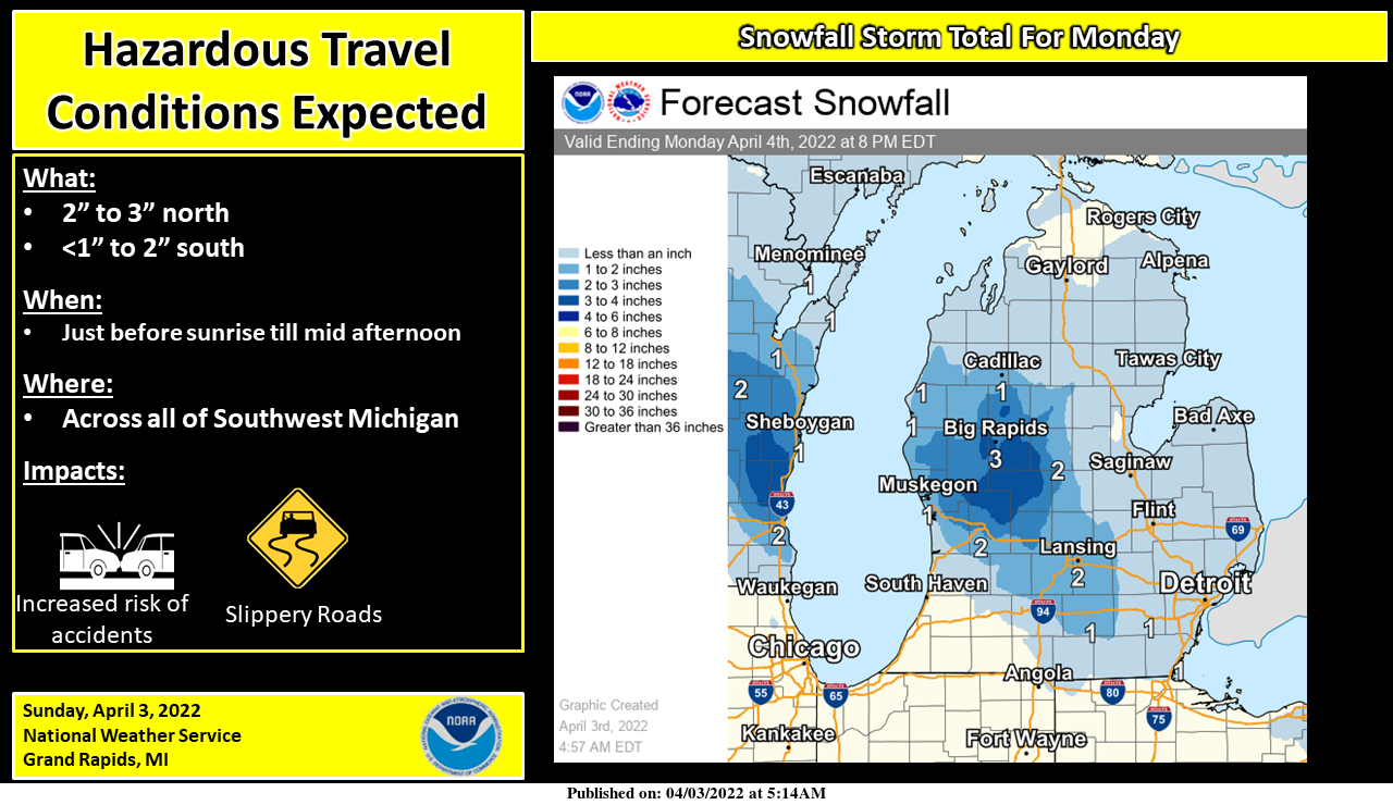
We are expecting yet another snow event for our area. The snow is expected to begin just before sunrise ( at 7:15 am) and end by early afternoon. The greatest snow accumulations are expected to be north of I-96.there will be reduced visibility in the snow, which may lead to accidents. Where the snowfall is heaviest, there may be some slush or icy on the less-traveled roads. Near and south of I-96 this event should be more rain than snow. Warmer weather returns by Tuesday, highs should reach into the 50s.
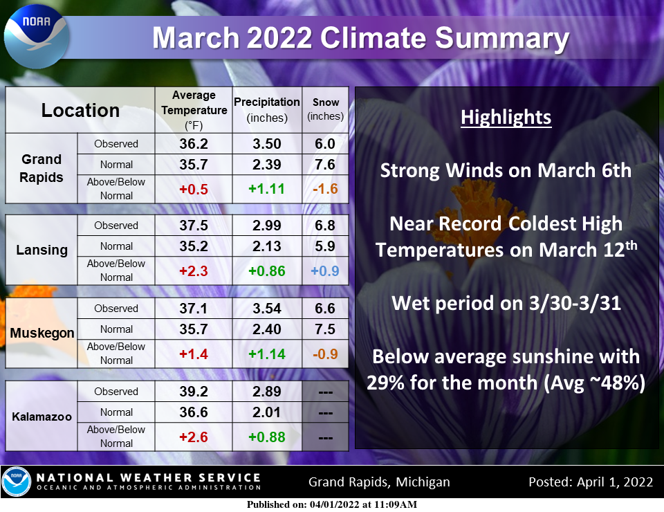
March 2022 was a typical spring month with up and down periods of temperatures throughout the month. Overall, temperatures averaged above normal for most areas. March 2022 ended up above average with regards to precipitation, but most of this fell over the last few days of the month with a wet system. Sunshine was below average with 29% of possible sunshine, compared to 48% being normal.
Forecast Discussion
...Chances for snow persist this week...

The parade of low pressure systems will keep moving across the Great
Lakes this week. Today will be dry across southwest Lower as a brief
period of ridging move overhead in advance of the next low. That low
will move through Monday. Strong isentropic lift ahead of it will
result in a quick saturation of the column after 06z tonight as
condensation pressure deficits fall to less than 5mb.
ECMWF/GFS/NamNest point toward light snow tonight and Monday
morning. Forecast soundings show almost all of the profile below
freezing. QPF amounts of a third to half inch corroborate model
projections of two to perhaps four inches of snow; higher amounts
north of I-96. Given surface temperatures around to slight above
freezing, travel issues should be kept to a minimum. It`s likely
that the precipitation will mix with and change to rain Monday as
the low moves through and warmer air becomes entrained into the
system.

After a dry Monday night and Tuesday morning, the next system in the
flow will arrive late Tuesday. This system is more dynamic and will
pull warmer air north and so the precipitation will be all rain.
Highs Tuesday and Wednesday will be in the mid 50s. Little in the
way of any CAPE points toward no thunder, so just rain. The low
occludes as it moves across Minnesota, so this will slow down the
eastward progress. We`re looking at around 18 hours of light rain
with this system. The occluded front will move through Wednesday
afternoon and bring in some drier air. However, we`ll still deal
with some wrap around moisture and scattered showers from the upper
low as it slowly moves across the state Thursday and Friday. Some
wet snow may mix in as well Thursday night and Friday.

A large upper ridge will settle over the region Saturday and Sunday
producing dry weather and seasonable high temperatures in the lower
Thank you for the birthday wishes! It was a great day with family. I see we are under a Winter Weather Advisory for tonight. Winter Weather Advisories have been issued a lot for the winter season this year.
Another WWA! I love it! The more mookie keeps taking about how warm temps are right around the corner the more more cold and SNOW we see! Bring it on! Rock n roll will never die! This is fantastic! Wow, just wow!
Bring it!
http://wxcaster.com/gis-gfs-snow-overlays.php?STATIONID=GRR
We have a WWA… although they are only forecasting up to 3 inches of snow with relatively warm surface temps, so I am a bit surprised one was issued
CPC just keeps getting redder and redder! Will April end up warmer than average like March?
I have a question for all the flower people. I know Daisies grow wild, but I would like to have some in a flower garden I started. It is nothing fancy I had a bunch of flowers that needed to be divided and put them in a spot. Any direction nas to what kind or where to get them. Would really mean a lot.
Anyone have suggestions on how to keep from sassafras shoots from grow back as well? We had a bunch of young twig looking shoots that we took down. This is where I planted flowers.
Thanks!!
Well another year older I go today! Looking foreword to spending some time with family today. Everyone have a wonderful Sunday!
Happy Birthday!!! Enjoy your time!!!
Happy Birthday, Kyle! 🎉🎂🥳🎊
Here in MBY I recorded 0.11″ of rain/melted snow yesterday and overnight. The overnight low both here and at GRR was 33. The official high at GRR yesterday was 41 At this time it is mostly cloudy and 35 here.
Slim
Good morning MV’s best we made it to Cape coral florida yesterday around 130pm the temperature was 91* degrees and muggy felt like Summer outside went from leaving with the heat on and snow showers to air conditioning and sunshine but there was a nice cool breeze off the Gulf of Mexico though check this out we dove 1,370 miles with about a 5 or 6 hour nap not bad drank lots of Gatorade and listened to music now its time to party and get a sun tan all week ….Enjoy the cold and snow in Michigan…lol….Indy
Have a good time down at the Cape. I have not been down there since my sister pasted away but before that we used to go down 2 or 3 times a year. Been down there in both the winter and summer. If you think it is hot there now go down in August. Anyway enjoy you summer weather there.
Slim
Thanks Slim heading to the beach today!! InDy
Enjoy your time! Florida has amazing beaches and I love visiting Everglades National Park and going on rides out there. Fun times.
Happy Birthday Kyle we enjoy having you on the Weather blog I will drink a sprite to you today!! Indy
Get ready for the next snowstorm! The winter that just keeps giving despite mookie constantly talking about how warm it is and how warm it will be! What a joke! Yesterday was yet again another double digit below normal temp day! We have had many of this lately! What a winter and now more snow is on the way! incredible!
http://wxcaster.com/gis-gfs-snow-overlays.php?STATIONID=GRR