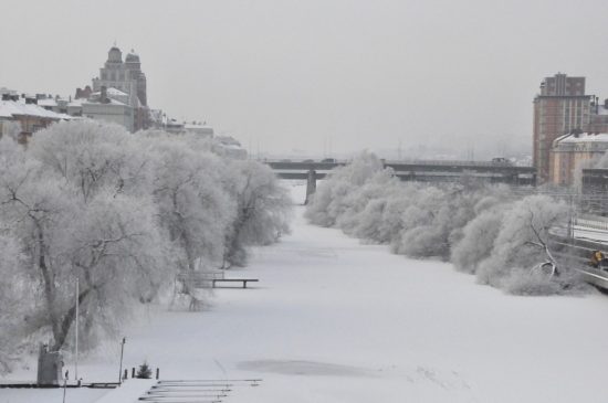
Seems I have been repetitious over the past few weeks with this blog – more cold, more snow seems to be the weather story once again. Luckily those of us who live inland of 131 are only getting an inch or three at a time. We have an engineer who recently moved to Holland and is rethinking her placement along the lakeshore and having to drive the M40 corridor to work everyday with the lake effect snows. It can be rough I know because I used to live in Hamilton and had to make that drive myself – 4x4s help but being able to see is another handy thing which can be hard with white out conditions.
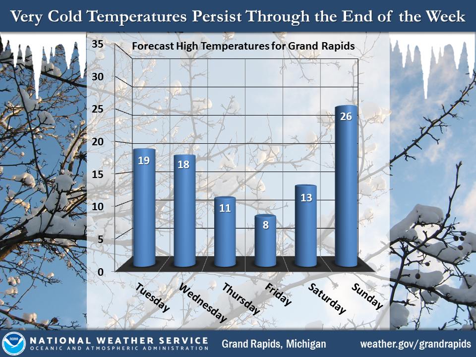
We have a lot of cats in the house some ours some belong to the neighborhood. They don’t want to be out in this cold weather and I don’t blame them we would rather give them a warm and happy home. The dogs don’t spend much time out there either, just long enough to do their thing then they rush back in. Below are the forecasted temperatures for the week and the records waiting to be broken.
[columns] [span6]
[/span6][span6]
[/span6][/columns]
Mason, Oceana, Muskegon, Ottawa and Allegan counties will be under a winter weather advisory from 1 AM Wednesday to 7 PM EST Thursday. Snow and blowing snow is expected to develop early Wednesday morning north of Muskegon then develop southward to Holland by sunrise. The snow is expected to be heavy at times from mid morning Wednesday through Thursday afternoon. Snowfall rates may exceed 2 inches and hour in some of the heavier snow bands. Total snow accumulations of 4 to 7 inches, with localized amounts up to 11 inches, are expected. Winds gusting as high as 30 mph will cause areas of blowing and drifting snow. Further inland along the 131 corridor will see only a couple inches.
The snow shower activity should come to an end by mid morning today as drier and slightly warmer air move into the area. There may even be a little sunshine this afternoon. Southwest winds bringing the below zero tempeatures from northern Indiana into extreme southern Michigan will keep wind chills there in the ten to twenty below range till late morning.
Tonight a clipper system heads southeast across Lake Superior then heads east and finally merges with a powerful nor-easter heading up the East Coast Thursday. This will bring a period of snow showers to the entire area Wednesday morning with the cold front.
Once the cold front has cleared the area north winds will set up persistent snow showers along the Lake Michigan shore area into Saturday morning. Those areas close to the Lake Shore could see well over a foot of snow between Wednesday morning and Saturday morning. Inland of that it will just be very cold Wednesday night into Saturday. There is the potential for a snow storm for the entire area Monday which will be followed by more lake effect snow after that.
So, our pattern of cold continues with more records to be broken…. we may see temperatures recovering next Sunday and Monday to around 30 or so which will feel like a heat wave.
Today: Mostly cloudy, with a high near 15. Wind chill values as low as -10. Southwest wind 10 to 16 mph, with gusts as high as 30 mph.
Tonight: A 30 percent chance of snow showers after 1am. Mostly cloudy, with a low around 6. Wind chill values as low as -12. South southwest wind 11 to 15 mph, with gusts as high as 28 mph.
Wednesday: Snow showers. High near 18. Wind chill values as low as -8. South southwest wind 9 to 13 mph becoming west northwest in the afternoon. Winds could gust as high as 22 mph. Chance of precipitation is 100%. New snow accumulation of around 2 inches.
Wednesday Night: A 40 percent chance of snow showers before 1am. Mostly cloudy, with a low around 4. Wind chill values as low as -7. North northwest wind 6 to 10 mph, with gusts as high as 20 mph.
Thursday: A 30 percent chance of snow showers after 1pm. Mostly cloudy, with a high near 12. North wind 6 to 8 mph.
Thursday Night: A 30 percent chance of snow showers. Mostly cloudy, with a low around -1.
Friday: A 20 percent chance of snow showers. Mostly cloudy and cold, with a high near 10.
Friday Night: A slight chance of snow showers. Mostly cloudy, with a low around -1.
Saturday: A slight chance of snow showers before 1pm. Mostly cloudy, with a high near 14.
Saturday Night: A chance of snow showers after 1am. Mostly cloudy, with a low around 6.
Sunday: Snow showers likely. Cloudy, with a high near 29.
Sunday Night: Snow showers. Cloudy, with a low around 23.
Monday: Snow showers likely. Cloudy, with a high near 31.
SNOW, SNOW and more SNOW! What a WINTER! Who would have thought?
http://wxcaster.com/gis-gfs-snow-overlays2.php?STATIONID=GRR
I just checked on Woodtv8 temp for Hudsonville is 3 degrees & windchill is -10. It is cold outside!!
More snow coming our way they say. The kids would be having snow days galore if it wasn’t Christmas break.
Hellooo WINTER!
http://wxcaster4.com/cfs/NORTH-AMERICA_CFS-NODE1_SFC_45DAY-ACCUM-PRECIP_180HR.gif
Nice color over us- happens to be one of my favorites. I need to take up cross country skiing.
I agree!
WOW! Hello SNOW country!
http://wxcaster.com/gis-gfs-snow-overlays2.php?STATIONID=GRR
WHOA!! i COULD GET A LOT OF SNOW!! 🙂
Keep the repetition going MV. COLD and SNOW rules!
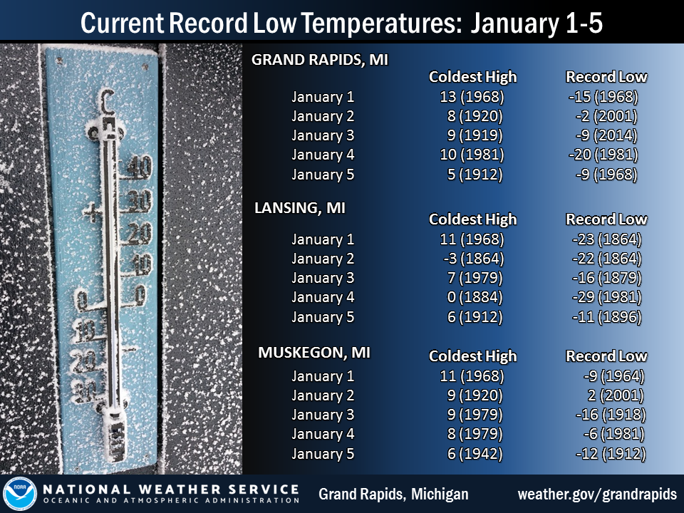
Climatology for today January 2nd At Grand Rapids, MI
The average h/l for today is 32/19
The record high is 59° set in 2004 the coldest maximum is +8 set in 1920
The record low is a mild -2° set in 2001 the warmest minimum is 52 set in 1897
The record snow fall is 6.4” in 1999
The most on the ground is 12” in 2001
Last year the High was 42° and the low was 24° there was 0.41” of rain fall and no snow on the ground.
slim
Thanks for the comparison to last year! I appreciate these facts that show this year is nothing like last winter! Our pattern has fully transitioned to colder than normal with multiple snow events on the horizon!
This morning there is a rather big temperature difference across the Grand Rapids metro area. At 9 AM the reading at the airport was +8° while here at my house it is +17° and to my NW at Muskegon it is +18° There is some blue sky to the NW so there is a chance that I will see some sun today. I had light snow overnight and the drive way has a new covering but not much and as GRR has been reporting light snow for the past several house that means Grand Rapids now has had snow fall… Read more »