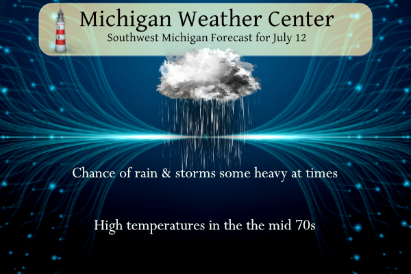
Our best chance of an inch or more of rain since April is coming today and tonight. We have had only 1.45 inches since June 1st and 2.60 since May 1st. Showers and thunderstorms will develop by this afternoon and continue tonight. Locally heavy rainfall is possible especially from Grand Rapids to the south. Highs will only reach the 70s.
Weather History for SW Michigan
July 9
1956: Cloudy and cool weather prevails with a record low maximum temperature of 64 degrees at Grand Rapids.
July 10
1895: Record cold temperatures occur on the second consecutive day at Lansing. The low of 39 degrees follows a low of 42 degrees on July 9th.
1897: A ten-day heat wave, one of the most intense on record, peaked with highs near 100 degrees across the region. At Lansing, it was the third straight day with highs of 100 degrees, unprecedented in the record books.
1996: Cool weather prevails with Muskegon setting a record low temperature of 44 degrees.
July 11
1945: Muskegon falls to 40 degrees, setting a record low for the date. This is also the second coldest temperature for the month of July at Muskegon, just a degree warmer than the 39 degrees on July 2, 2001.
1957: Thunderstorms struck West Michigan with heavy rain and high winds. There was widespread flooding of streets, with some road washouts. The 3.19 inches of rain at Lansing made this the wettest July day of the 20th century there. Many trees were blown over by thunderstorm winds and lightning struck a TV antenna in Grand Rapids, burning out the transmission line.
1967: A tornado damaged a trailer, garage, and silo about two miles west of Ferry in Oceana County.
July 12
1966: A tornado destroyed a barn at Coopersville in Ottawa County.
1978: Cool weather prevails with low temperatures in the 40s. Muskegon falls to 45 degrees, for a record low for the date.
July 13
1912: A tornado strikes downtown Grand Rapids at 4:10 AM. Several buildings are damaged and nine people are injured.
1936: The Dust Bowl summer of 1936 produces the hottest day on record across the state of Michigan. Grand Rapids hits 108 degrees, its highest temperature ever, with Mio, Michigan setting the state record of 112 degrees. At Grand Rapids, six out of the seven days from July 8th to July 14th were above 100 degrees.
1964: Clouds, rain, and a cool northeast wind hold the high temperatures in the upper 50s to mid-60s across West Michigan. The high of 59 degrees at Grand Rapids is only the second time in over a hundred years of record that the temperature did not reach 60 degrees on a July day.
July 14
1950: Cold air filters into Michigan, setting records lows of 45 degrees at Grand Rapids and 41 degrees at Muskegon.
1974: Several tornadoes struck Lower Michigan during the afternoon, causing some structural damage but no injuries. In Mecosta County, a house and some farm buildings were damaged about four miles east of Sylvester. Apartment buildings were damaged near Plymouth, in Wayne County. Seven houses were destroyed and 50 damaged near Davison in Genesee County.
1995: An intense three-day heat wave claims hundreds of lives across the Midwest, mostly elderly people in the greater Chicago area. The low temperature of 81 degrees at Grand Rapids on this day is the warmest low temperature ever recorded there. Temperatures in the upper 90s in the afternoon combined with high humidity to produce heat index readings near 120 degrees, some of the highest ever recorded.
July 15
1863: It was a frosty morning with temperatures falling to the 30s across much of Michigan. The low of 31 degrees is the coldest ever recorded in July at Lansing by a full five degrees.
1961: A heavy downpour hits Grand Rapids, with 0.41 inches of rain falling in 15 minutes.
1985: A tornado touched down in the northeast section of Lansing and damaged 18 buildings as it moved to three miles north of Webberville in Ingham County.
1987: It was the coolest July day on record at Grand Rapids, with a high of only 58 degrees. Clouds and rain kept temperatures in the upper 50s and lower 60s during the day after morning lows in the mid-40s.
Weather History for SE Michigan
July 9
On July 9, 1988, the temperature soared to 100 degrees in Flint, which is the record high for the day. This marked the fifth day in a row (July 5-9) that record daily high temperatures were recorded in Flint.
July 10
On July 10, 1898, the temperature dropped to 40 degrees in Saginaw. It was the second-coldest temperature on record for the month. The coldest is 39 degrees.
July 11
On July 11, 2022, a weak EF0 tornado formed near Lake Fenton and tracked east-southeast to Holly State Recreation Area from 11:33 pm to 11:42 pm.
On July 11, 1964, Genesee County experienced 1.75-inch hail and winds up to 58 mph around 5:50 pm.
July 12
On July 12, 1966, Detroit had a record amount of precipitation fall in 24 hours. They received 3.19 inches.
July 13
On July 13, 1936, the temperature soared to 111 degrees in Saginaw, which is all-time record high temperature ever recorded in either Saginaw, Detroit, or Flint! This day also marked the sixth day in a row (July 8-13) of daily record high temperatures in Saginaw.
On July 13, 1995, The “right turn derecho” plowed south-southeast down across East and Southeast Lower Michigan on its way toward Ohio.
July 14
On July 14, 2000, parts of the north and west suburbs of Detroit received golf to tennis ball size hail with a severe storm that pushed through.
Also on July 14, 1992, Detroit had a high temperature of 83 degrees. This is about the average high temperature for mid-July, but it was the warmest day in Detroit in July of 1992, the second coldest July on record and part of the “Cold Summer of 1992”.
July 15
On July 15, 2010, severe thunderstorms moved through most of Southeast Michigan. There were 32 severe weather reports including a measured 71 mph wind gust near Davison and wind damage consistent with winds up to 80 mph in Flushing. Most of the reports were wind gusts and associated wind damage, but there were a few isolated large hail reports.
Also, July 15, 1988, would mark the last day of a 23-day dry spell in Southeast Lower Michigan. There was a total of only 0.04 inches of rainfall during those 23 days.
Grand Rapids Forecast
7-Day Forecast 42.96°N 85.64°W (Text-Only)Update:
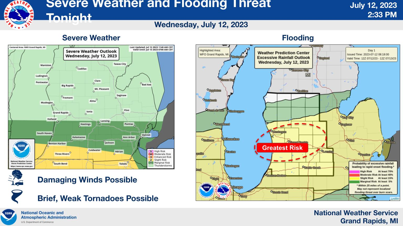
Thunderstorms move into the area after 4 PM. Some will have the potential to produce damaging winds and even brief weak tornadoes between 7 PM and Midnight along and south of a Holland to Lansing line. However, the threat area could shift slightly north to include the Grand Rapids area. There is a high likelihood of some flooding tonight, especially in urban areas and with small streams. Larger rivers should see little or no flooding. The heaviest rainfall will occur around I-96 and be a little less heavy farther south towards I-94. The greatest localized flooding risk will be between 8 PM and Midnight tonight.
Forecast Discussion
.SHORT TERM...(Today through Thursday)
Issued at 406 AM EDT Wed Jul 12 2023

Current radar shows an area of light to moderate rain showers
over Wisconsin moving east towards Lower Michigan. The heavier
rains are further south across Iowa into northern Illinois where
clusters of thunderstorms are moving east-southeast and should not
affect our area this morning.

Model consensus in the short range is that a cluster of storms
currently over eastern South Dakota will become an MCS and move
east along the stalled front/baroclinic zone, eventually arriving
in southwest Lower Michigan between 2 and 4 pm and laying down a
swath of inch plus rains across roughly the southern half of the
forecast area.

Severe weather threat appears limited to localized downburst
winds in bowing line segments with unidirectional shear profiles
and deep layer shear of about 25 to 30 knots. The heavier rains
move east this evening with mostly stratiform showers into
Thursday morning and then a few thunderstorms Thursday afternoon
as CAPE spikes up to over 1000 J/kg


.LONG TERM...(Thursday night through Tuesday)
Issued at 327 AM EDT Wed Jul 12 2023

The upper low over southern Hudson Bay will slowly sink south with
time across Ontario and eventually the U.P. by the middle of next
week. The parade of short waves rotating around the low will result
in enhanced chances for rain through the period.

The first such time frame is Friday afternoon through Saturday
afternoon. ECMWF and GFS show a wave moving across Lower MI Friday
afternoon. A nice influx of moisture ahead of the wave will enhance
precipitation chances; PWATs climb to around 1.5 inches Friday
afternoon. 30-40kts bulk shear may also result a few stronger
storms.

Monday may be another day we see higher chances of showers/storms.
This is when the core of the upper low dips south and pushes a vort
lobe across the Lower Peninsula. Once again, PWATs increase to
around 1.5 inches and locally heavy rainfall will be possible.

Highs will be mostly in the 80s, except Tuesday and Wednesday when
temperatures will be a bit cooler due to the upper low moving south
over the region.
Another 1.8 inches of rain here! Wow, just wow, Wow!
Noisy now, with the final storms sliding by to our South.
It would be helpful if you list your location, because your comments are not relevant concerning the the weather conditions, unless we know your location!
Reflectivity seems pretty high just west of Hastings, close to Irving, at the moment.
Currently getting heavy rain and thunder here. Heaviest of the night so far actually. It’s been raining since ~6:30 or earlier here
Rain picking up. Thunder and lightning here.
Same here. Pouring with lightning.
Debris ball on radar for the tornado warning west of Paw Paw
Updated Convective Outlook
https://www.spc.noaa.gov/products/outlook/day1otlk.html
Tornado watch for southern 3 rows of counties!
I’ve got clouds moving three different directions…over and under each other;)
Getting some lighting in that line of storms SW of Grand Rapids. It is getting very dark to the SW at this time.
Slim
Hearing some thunder…
* Severe Thunderstorm Warning for… Van Buren County in southwestern Michigan… Allegan County in southwestern Michigan… * Until 1015 PM EDT. * At 842 PM EDT, severe thunderstorms were located along a line extending from 5 miles southwest of Saugatuck to 14 miles northwest of Stevensville, moving east at 25 mph. HAZARD…60 mph wind gusts. SOURCE…Radar indicated. IMPACT…Expect damage to roofs, siding, and trees. * Locations impacted include… Allegan… South Haven… Paw Paw… Wayland… Otsego… Plainwell… Hartford… Mattawan… Lawton… Bangor… Decatur… Fennville… Saugatuck… Martin… Van Buren SP… Lake Michigan Beach… Pine Grove… Covert… Ganges… Keeler…
Quite the active evening! This is the most rain to move through the area (well, north of 1-94) got a while. And some tornadoes to our SW
My bro in law is in Elmhurst just SW of O’Hare. He just FaceTimed me after the storm went over his house. He went out front so we could see the backside of the storm. You could clearly see the rotation and a funnel trying to form. This was about ten minutes ago. So cool.
Crazy.
Tornado on the ground near Elgin Illinois
Confirmed large tornado down. PDS warning for downtown Chicago.
Large limbs broken & power poles down per mPING reports
Not a good situation.
Tornado down near Hodgkins IL (Cook County)
Four tornado warnings in NE Illinois
Wow that is some intense rain moving in… looks like near 1-96, give or take 30 miles, will be the heaviest swath
Had some moderate rain move thru. It is now just light rain falling at this time. There is more rain to the west at this time. Looking at the lightning map there is not much lightning any ware on the map. So do not expect much in the way of thunderstorms at this time.
https://www.lightningmaps.org/?lang=en#m=oss;t=3;s=0;o=0;b=;ts=0;y=40.0981;x=-82.9058;z=7;d=2;dl=2;dc=0;
Slim
Tornado watch upstream for the Chicagoland area.
Holland to St John’s and points south under Slight Risk now for Severe Weather. Tornado Probabilities of 5% expanded north from Holland to Lansing south. 2% tornado probabilities as far north as GR.
Interesting to note NE Illinois has an Enhanced Risk and even 10% hatched probabilities. We shall see how it plays out.
Tornadoes?…honestly. Let’s just start off with accomplishing something simple. How about an inch or more of rain?
Agreed!!
Overall today turned out to be a pretty decent day. Plus it got warmer than anticipated. I like it!
LATEST UPDATE… Short Term/Long Term/Marine .SHORT TERM…(This evening through Thursday night) Issued at 303 PM EDT Wed Jul 12 2023 …Impactful weather likely tonight… The threat for severe storms and heavy rainfall continues to be the primary focus tonight. Late this afternoon, a warm front extends from northern Illinois to southern Lake Michigan to far southeast Lower Michigan. This front will lift north across the I-94 corridor this evening /approaching GRR-LAN/ as convective complex over parts of WI/IL moves east into the region – along with an associated surface low. These features are forecast to be east of the area… Read more »
Thunderstorms move into the area after 4 PM. Some will have potential to produce damaging winds and even brief weak tornadoes between 7 PM and Midnight along and south of a Holland to Lansing line. However, the threat area could shift slightly north to include the Grand Rapids area. There is a high likelihood for some flooding tonight, especially in urban areas and with small streams. Larger rivers should see little or no flooding. Heaviest rainfall will occur around I-96 and be a little less heavy farther south towards I-94. The greatest localized flooding risk will be between 8 PM… Read more »
We have received over 7 inches of rain the last 2.5 weeks, so what is another inch or two? Wow!
That’s a lot of rain. I know that you’re not in GR, but it’s pretty amazing what a few miles will do. You received like five inches more than the Ford airport during that same time.
Yes incredible and to my North they even got more rain!
I got laid off from my job this morning, not the most enjoyable day for me!
I see we have a flood watch for tonight… 2-4 inches, locally 5. IF this is true and it is area-wide, that would surely put a dent in the drought
A job lay off = many different opportunities ahead! Good luck!
Bummer!!! Hope this opens other doors for you!
That stinks. Sorry Nathan. I try to be a glass half full kind of person. At least it happened now when the unemployment rate is at historic lows. Lots of jobs to choose from.
Sorry to hear that Nathan! I wish you the best with what comes next.
Thanks everyone! There are definitely lots of jobs to choose from, so it’s only a matter of time
Sorry to hear that Nathan. At least the job market is not bad at this time. Good luck in finding a new job.
Slim
Like other areas it is still incredibly dry here. Hope we get at least some rain, but a flood won’t help the drought conditions. Instead of saturating the ground it will all just run off into the lakes and rivers.
It is dry here as well. Yes..we need a nice soaking rain not a downpours to cause flooding.
The grass is crunchy here too.
Interesting to note SPC brings 5% tornado probabilities into Southern Michigan.
The Slight Risk for Severe Weather includes areas south of I-94. The Marginal Risk comes up to just south of GR.
Flood Watch for Allegan, Barry, Eaton, Ingham, Ottawa, Kent, Ionia, Clinton, Muskegon, Montcalm, Gratiot and Newaygo Counties.
“Thunderstorms with heavy rainfall will move into the region later this afternoon and into tonight. Repeated rounds of thunderstorms are possible over the same areas over the course of several hours. Storm total rainfall amounts of 2″-4″ are expected with some localized amounts to 5″ possible.”
Flood watch has just been posted….INDY
Drought, what drought?
We didn’t get a drop of rain overnight.
It’s been a great start to the day lots of sunshine at my house. I have a current reading of 74.
More rain and getting into cool and wetter pattern reminds me of Fall in mid July wow to the wow ….INDY
Yes and we are really locked into this cool pattern and no heat waves are in sight! Incredible!
GR is right on pace for another near to below normal temp month! Wow!
Took all my hanging plants down to get a good drink… Come on!! Maybe we need to wash a car or something?!? LOL!!
🙂 LOL!!
Currently +2.6 degrees above average for July. It’s been a warm start to the month.
C’mon rain! Mid Michigan is thirsty!
Over the past 2 weeks I have seen rain of more than 1 inch on four separate days! Incredible rain totals and the grass is green and growing very fast! I repeat no drought here and tons of rain lately!
Form above. 1912: A tornado strikes downtown Grand Rapids at 4:10 AM. Several buildings are damaged and nine people are injured. “I did not know that” That is something.
Slim
The official H/L yesterday at GR was 82/61 there was a trace of rain fall. There was 67% of possible sunshine the strongest wind gust was 27MPH out of the west. There were 7 CDD’s and the total for July so far is 86 that is a departure of -2. The overnight low this AM in MBY has been 58 at the current time it is 60 with cloudy skies. For today the average H/L is 83/63 the record high of 106 was set in 1936 and the record low of 42 was set in 1989. The record rain fall… Read more »
The coldest maximum for today is 71 set in 1917. With clouds and rain we will have to see how warm it gets today as there is a good chance it will be one of the cooler maximum temperatures for the date. There is a chance of some heavy rain today. And there are several chances of rain for the next week. We will be going on a short trip next week and will be in northern Ohio for a few days. We are going to Put in Bay and then to the Rock in Roll Hall of fame. My… Read more »
What? More below normal temps! Who would have thought!
Have fun, Slim. I have not been to the RnR HOF either. Someday, for sure.