
WOW! My how the days fly by. This is the last day of Meteorological summer which will be noted for long dry spells, an August with the most tornadoes in a single day (with record or near record dewpoints), and of course the smokey skies from Canadian wildfires. We finish August with 3.73 inches of rain, bringing our summer total to 9.73 inches (in Otsego). Our driest month was June with only .84 of an inch and our wettest was in July with 5.15 inches.
Today will feature sunny skies with temperatures in the mid-70s. The rest of the week into Labor Day we will see temperatures gradually rise into the 80s with 90° on Monday.
Grand Rapids Forecast
8 31 grrU.S.A and Global Events for August 31st:
1886: A magnitude 7.3 earthquake shook Charleston, South Carolina around 9:50 pm on this day. This earthquake was the most damaging quake to occur in the Southeast United States. This earthquake caused 60 deaths and between 5 to 6 million dollars in damage to over 2,000 buildings in the southeastern United States. Click HERE for more information, including pictures, from the USGS.
1922: An incredible hailstorm occurred near West Chester, PA dropped so much hail that fields were covered with up to two feet of drifted hail the next day.
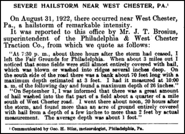
The article above is courtesy of the Monthly Weather Review published in 1922.
1935: The most intense hurricane to make landfall in Florida was a modest tropical depression on this day. Called the Labor Day Hurricane, this storm went through phenomenal intensification to become a Category 5 hurricane by September 2nd.
Forecast Discussion
.SHORT TERM...(Today through Friday)

Subsidence under high pressure directly over lower Michigan will
result in mostly clear skies today as also suggested by IR sat
trends which show mostly clear skies across our region.

We expect a rather large diurnal swing in temps today with clear
skies and a dry airmass in place. High temps will reach the low to
mid 70s this afternoon after a cool start to the day with temps
mainly in the 40s across our area early this morning.

High pressure will continue in control of our wx pattern through
Friday resulting in mostly clear skies. Temps will moderate Friday
as winds become southerly on the back side of the departing sfc
ridge. High temps Friday will reach the upper 70s to lower 80s.

.LONG TERM...(Friday night through Wednesday)

- Warm and Dry Weather Dominates Through Early Next Week

Little change in expectations for the holiday weekend, but some fine
tuning of the forecast is needed. Upper heights will still be
building across the Great Lakes with low level warm advection
helping boost our temperatures to 10 degrees or more above normal. A
branch of the upper jet is shown to arrive on Saturday, with some
upper lift and an enhancement to mid/upper level RH moving through
Lower Michigan at that time, especially from I-96 to the north. What
this will help produce is some mid and high level cloud cover. Some
deterministic guidance is trying to squeeze out some light showers
near and north of U.S. 10 on Saturday, though with LCLs at or above
700mb and a fairly dry subcloud layer, it`s hard to imagine anything
more than a few sprinkles or just some virga in the sky across
central Lower Michigan. Sunday into Monday looks sunnier with less
mid/high level RH.

High temperatures may be held down a bit on Saturday near/north of I-
96 due to some cloud cover, thus upper 70s may be more the rule as
opposed to 80s, which are more likely south of I-96. Steady warming
Sunday into Monday will boost temperatures into the upper 80s to low
90s away from Lake Michigan. Right along the lake will be several
degrees cooler but still rather warm. Ensemble guidance suggests
Tuesday will still be quite warm, or hot, given we`ll be on the
northwest portion of the upper ridge.

- Rain Possible By Wednesday

Ensemble guidance is in fairly good agreement at this long range
with regard to longwave troughing starting to dampen out the upper
ridge across the Great Lakes by midweek. An upper jet is shown to
push into our region at that time, with a cold front at the surface
poised to move through, but a modest drop in temperatures appears
most likely with near to slightly above normal temperatures behind
the front. If we can muster another warm or hot day on Wednesday
ahead of the front, that could make things interesting as dew points
are shown to rise to around 70 degrees. Thus, we`ll be monitoring
for thunderstorm potential for that midweek period.
Just another of many below normal temp days! Wow, what a stretch! Who wouldn’t love below normal temps in the summer?
I never heard of that S. Carolina earthquake. 7.3? WOW