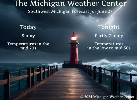
We will have a pleasant day in store with sunny skies and lower humidity. Temperatures will be in the 70s, a great day to be outdoors. Tomorrow we will see increasing cloud cover through the afternoon, with highs near 80 degrees. The chance for rain will increase towards and during the evening.
NWS Forecast
Weather History
1875: Tornadoes struck Detroit and Jackson during the late afternoon and early evening. The Detroit tornado killed two people and injured 25 others.
1914: A tornado struck Gratiot County, destroying several buildings as it moved from North Star to three miles north of Edgewood. A barn door was carried nearly a mile.
1944: A three-day heat wave peaked with high temperatures of 97 degrees in Grand Rapids and 93 degrees at Lansing.
1968: Cool and cloudy weather prevailed with high temperatures only in the upper 50s to lower 60s.
On June 27, 2010, a warm front lifting north through Southeast Michigan spawned three tornadoes. The community of Willow in southwest Wayne County was hit with and EF1 tornado. Later another EF1 tornado hit a campground outside of Wadhams in St. Clair County. Unfortunately, there was one death and four injuries as a result of that tornado. Finally a brief EF0 tornado touched down on the far southeast side of Marlette in Sanilac County.
Also on June 27, 2007, thunderstorms anchored themselves over northern Shiawassee County. Estimates of around 8 inches of rain fell near Henderson, washing out several gravel roads.
Forecast Discussion
- Quiet through Early Friday

Surface high pressure will hold over the region through early Friday
leading to quiet and dry weather. Comfortable temperatures in the
70s to low 80s are expected with dewpoints around 50 to 55. Wind
will stay primarily northerly today and will shift southerly
Friday morning ahead of an approaching system Friday night into
Saturday.

- Showers and storms Friday Night/Saturday

A belt of fast westerlies persists across the northern CONUS through
the late week and into next week. Shortwave troughs will bring a
chance of rain late Friday into Saturday and again Monday night into
Tuesday. In between there will be a Canadian surface high bringing
low humidity and cool temperatures.

Rain chances increasing Friday afternoon and evening as moisture
pools ahead of the advancing cold front. Model consensus still has
the greatest chance for showers and storms late Friday night.

A severe weather threat may be possible late Friday night into early
Saturday as Lower Michigan is in the warm sector and model soundings
show around 30 knots of shear ahead of the cold front. The limiting
factor is the diurnal minimum instability and the persistence of
convective inhibition during the expected late night timing of the
storms.

- Cool High Pressure for early Next Week

Surface high builds in behind the front with dry and cool weather
for Sunday into Monday, then another chance of showers as the next
shortwave trough approaches Monday night and Tuesday. Lows Sunday
night expected to dip down into the 40s in the rural areas.
69 degrees with a dew point of 47 feels so refreshing. Beautiful outside.
Nice to wake up to 60 instead of 70. Cool dry breeze. Windows are open!
Nice cool morning with more below normal temps on the way! Who would have thought?
The overnight low here in MBY was 55 there was no rainfall. The current temperature is 57 with a DP of just 50. With clear skies.
Slim
The official H/L yesterday at Grand Rapids was 83/62 that is just about a average summer day at GR. There was no rainfall the sun was out 39% of the time. The peak wind gust was 23MPH out of the N. For today the average H/L is 86/62 the record high of 97 was set in 1933,1947 and 1913. The coldest high of 60 was set in 1968. The record low of 45 was set in 1902 and 1905. The most rainfall of 1.30” was in 1921.
Slim