 I installed my new improved CoCoRaHS rain gauge yesterday. If you want one it can be purchased at Amazon, then you can join the CoCoRaHS community.
CoCoRaHS is an acronym for the Community Collaborative Rain, Hail and Snow Network. CoCoRaHS is a unique, non-profit, community-based network of volunteers of all ages and backgrounds working together to measure and map precipitation (rain, hail and snow). By using low-cost measurement tools, stressing training and education, and utilizing an interactive Web-site, our aim is to provide the highest quality data for natural resources, education and research applications. We are now in all fifty states.
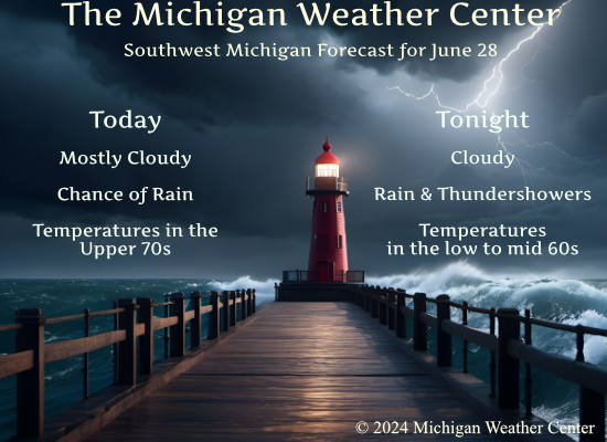
NWS Forecast
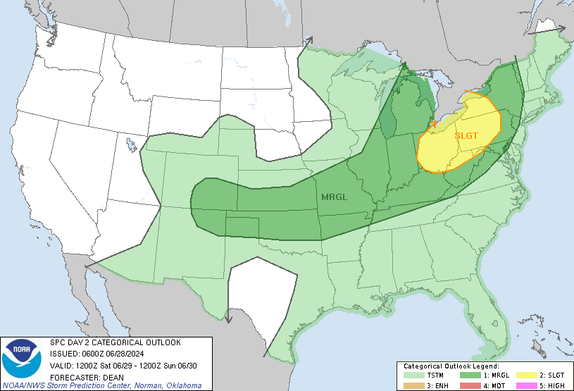
SPC Day Two Forecast
Weather History
1959: Hot weather prevailed with a high temperature of 92 degrees at Grand Rapids and Lansing. At Grand Rapids, the low temperature was 78 degrees, second only to the 79-degree low on June 20, 1953, for the warmest low temperature on record for the month of June.
On June 28, 1934, the temperature soared to a high of 104 degrees in Detroit! Many were treated for heat exhaustion and three people died from the hot temperatures.
Forecast Discussion
- Increasing Showers and Storms Tonight into Saturday

Lingering surface high pressure keeps conditons quiet this morning
while focus turns to this afternoon and into Saturday for showers
and storms.

Starting this afternoon, mid-level shortwave energy embedded in
ridging will trigger increasing shower activity. Low level profiles
look quite dry, so wouldn`t expect too much precipitation to reach
the surface and a few "virga showers" across the area. Profiles
moisten up into Saturday morning as the parent low moves across
southern Ontario and a trailing cold front approaches. As a
secondary low develops along the southern edge of the front south
of the state line, a warm front will lift north and trigger
elevated showers across southern Michigan early Saturday. Diurnal
instability will build into the early afternoon ahead of the
lagging cold front. Favorable deep-layer shear will support at
least an isolated severe thunderstorm threat Saturday afternoon
and evening as the cold front sweeps through. Damaging wind gusts
and hail will be the primary hazards to monitor for.

- Cool High Pressure for early Next Week

Upper troughing with Canadian surface high building overhead will
provide dry and cool weather for Sunday into Monday. Lows Sunday
night expected to dip down into the 40s in the rural areas and even
some upper 30s in the cold hollows. The surface high moves east on
Tuesday with warm advection and moisture return ahead of the next
shortwave trough.

- Rain chances mid/late week

Shortwave ridging late Monday into Tuesday is flattened and replaced
by low amplitude troughing on Wednesday, which persists the rest of
the week. Low confidence in the timing/details of rain given
individual model and ensemble spread but the general consensus is
that a cold front will bring showers and thunderstorms late Tuesday
night into Wednesday with the front hanging up just south of Lower
Michigan and another surface low forming along this baroclinic zone
by the Fourth of July.

At this point it looks like bulk of showers and storms may remain
just to the south of Lower Michigan after Wednesday but chance POPs
in the forecast will cover the potential for the front/sfc low to
move further north.
It sure has been a cool end of the week! WOW!
It sure has been a warm start to 2024 and to summer! I love it!
Clouds need to move read there’s a G4 storm…
Where is all the heat that’s. Suppose to be here ??lol….looking like rain clouds and a cooler July with peaks of sun as far as the eye eyee can see but who is complaining not INDY … I’m heading north for the weekend and have my hoodies packed such a bonus for July stander yeahhhh …let’s Goooo INDY
Nice comfortable temps. Yesterday was great, today looks great as well. Overall the forecast at this point looks nice.
The overnight low here in MBY was 61 at the current time it is 63 and cloudy.
Slim
The official H/L yesterday at Grand Rapids was 73/54 there was no rainfall the sun was out 78% of the time. The highest wind gust was 22 MPH out of the N. For today the average H/L is 82/61 the record high of 97 was set in 1931 and 2012 the coldest high of 65 was set in 1923 the record low of 43 was set in1992 the warmest low of 78 was set in 1959. The most rainfall of 2.33” fell in 1957.
Slim