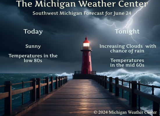
Yesterday was a nice break from the heat and humidity. We had a high of 82 and a morning low of 62°. Dewpoints were back to a more pleasant 50s. After a sunny and pleasant day today, our next chance of showers and storms returns for late tonight and Tuesday.
There are still no mosquitoes in our area but I have a sneaking suspicion they will come if we keep getting consistent rain. We do live in the woods near the Kalamazoo River so it is only a matter of time. I have noticed a lot more flies and a few deerflies which are not a usual pest in our area.
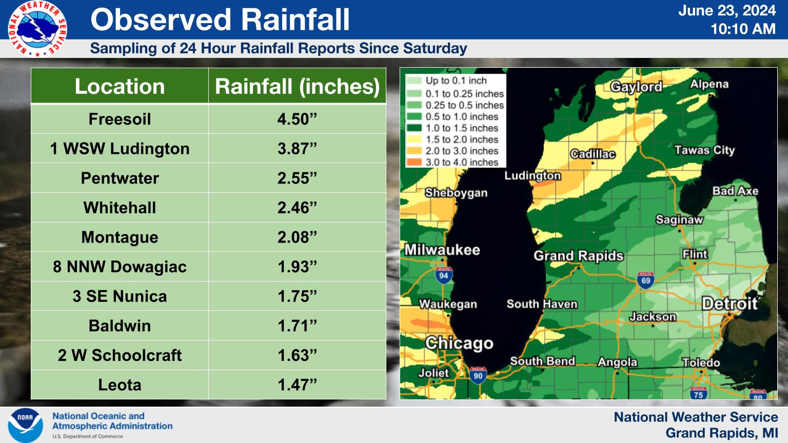
Rainfall totals since Saturday morning reached 1″-4″ across portions of western and central Lower Michigan. Here is a sampling of reports and a map of estimated rainfall. Mason County received the most, with some locations there picking up around 4″ or even slightly more than that. The least amount of rain fell near and east of I-69 and toward US 127, where generally 0.25″-0.50″ was received.
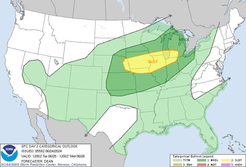
SPC Forecast Day Two
NWS Forecast
Weather History
1998: A severe thunderstorm produced hail up to 3 inches in diameter and two tornadoes as it tracked across Eaton and Jackson Counties. The first tornado touched down just east of Eaton Rapids and downed trees and power lines. The second tornado hit Layton Corners in north-central Jackson County. This tornado did about half a million dollars in damage as it did minor damage to about a dozen homes.
On June 24, 1998, a series of supercell thunderstorms swept through southeastern Michigan, producing hail up to 1.75 inches in diameter and substantial wind gusts. A spotter in Ypsilanti estimated wind gusts of 75mph! One injury was sustained this afternoon due to a fallen tree limb. Damage across southeastern Michigan totaled $82,000.
1944: The deadliest and strongest tornado in the state of West Virginia occurred on this day. The Shinnston Tornado that ravaged a path of destruction from Shinnston to Cheat Mountain, then on to Maryland and ending in Pennsylvania in the Allegheny Mountains, is the only twister to produce F4 damage in West Virginia. This tornado killed 103 people. Click HERE for more information from the History Channel.
2010: An F2 tornado destroyed approximately 50 homes and caused damages estimated to be $15 million in Midland, Ontario. 12 people were reported to be injured. Ontario provided immediate provincial assistance of up to $1 million to aid in cleanup and repairs.
Forecast Discussion
- Mostly sunny today, stormy late tonight/Tuesday morning

Every model run of the GFS since last Wednesday has had some
flavor of an MCS developing over MN/northwest WI tonight and
moving southeast across WI and then over Lower MI. The CAMs caught
on to that scenario too over the weekend with some taking the MCS
south across WI and into northern IL. However, a few others
continue to take the MCS across MI...either northern Lower or
across the GRR cwa. The model consistency alone gives some
confidence that storms are going to form tonight to our northwest.
The question is where are they going to go.

Model thermodynamics/kinematics point toward a classic MCS
scenario in which an upper short wave induces low pressure over
the northern Plains in concert with a northward moving warm front.
A strong nocturnal LLJ then pushes moisture toward the front like
a fire hose with storms developing near the triple point of the
warm front/cold front. Models tonight show a 55 kt LLJ pointed at
the warm frontal boundary and moving east with time so that the
LLJ is over the cwa by 12z. Meanwhile, a 60-70 kt mid level jet
pushes the storms east along the warm front following mid level
thickness contours to the ESE. The key to whether we see storms
over the cwa tonight will be how far north they develop. If they
develop over southern MN, then they should be more inclined to
take a southeast turn across southern WI/northern IL. However, if
they develop farther north, chances are greater that they will
move across northern WI and cross the lake and move southeast
across the cwa after 08z.

There`s also some uncertainty surrounding how strong the storms
will be. Shear values are aoa 40 kts which suggests organization
is possible. Given the strong mid level winds, damaging wind is
the main threat. There is some mid level capping that would likely
be overcome by a mature MCS.

The entire CWA is in a marginal risk for severe storms tonight
and Tuesday. The southwest cwa is in a slight risk for severe
storms Tuesday due to the potential for storms to fire on the
trailing cold front that models suggest will be in the vicinity of
the WI/IL border east toward the I-94 corridor. There`s a lot of
uncertainty around whether storms will develop over the southern
cwa Tuesday afternoon, because it depends on what happens with the
Tuesday morning convection. It`s possible that storms Tuesday
morning essentially push the cold front south of the cwa and we
don`t get any redevelopment Tuesday afternoon. Less convective
activity late tonight would likely result in higher chances for
storms Tuesday afternoon.

Storms that develop over the southern cwa Tuesday afternoon will
have the potential to train as they move east which would result
in a heavy rain threat.

- Medium/High confidence in fair weather Wednesday and Thursday

The flow regime across the Great Lakes this week is dominated by two
shortwave troughs in quasi-zonal flow between subtropical ridging
across the southern CONUS and an upper low across central Canada.
THe first trough is moving through by Wednesday with showers ending
early and sfc high pressure building in with fine summer weather for
Thursday into early Friday.

- Medium confidence in showers and storms late this week

The surface high moves east with warm advection pattern developing
which could bring showers by Friday morning and more likely Friday
night and Saturday as the next trough moves through. The usual
ensemble spread at that time range makes the timing of the showers
and storms hard to pin down, but the highest chances appear to be on
Friday night. A severe weather threat is possible at that time as
Lower Michigan is briefly in the warm sector and model soundings
show 30 to 35 knots of shear ahead of the cold front.
IMO, today is a picture perfect summer day. Very warm, but not too warm. Nice breeze. Lots of sunshine.
Looks like there’s a decent chance of storms overnight and possibly tomorrow. Everything is very green here. I drove by Reese’s Farms (the best sweet corn) and their corn is shoulder high, if not higher. It looks to be a bumper crop this year.
I was across the lake this weekend so not sure exactly how much rain fell in our area. I can say though we were staying at a hotel near Waukegan, Illinois north of Chicago and we got a severe thunderstorm warning and lots of heavy rain. It rained hard for quite a while. Think the local met said 4-5” of rain fell. We had a flash flood warning as well when there.
We received some rain overnight. Not long last, but pretty heavy for a few mins.
.02 fell in Otsego
Seemed like more… I will take what we can get… LOL!!!
June is currently +3.1 degrees above average. The warmth just won’t stop!
There was 0.55” of rainfall here in MBY overnight I was surprised to have that much. The overnight low was 58 and the current temperature is 61 with clear skies.
Slim
Thunder, lighting and moderate to heavy rain! Who would have thought! I have picked up 4+ inches of rain in the last week! Incredible!
I think I’m at about 2.5 inches over here in Northern Kent! I did see that Rockford got blasted the other day with Storms, we just missed out on that.
It had some incredible rainfall rates!
The official H/L yesterday at Grand Rapids was 77/64 there was 0.34” of rainfall. The highest wind gust was 34 mph the sun was out 38% of the possible time. For today the average H/L is 82/61 the record high of 96 was set in 1901 and 2009. The coldest high was 62 in 1994 the record low of 41 was set in 1961 the warmest low of 73 was set in 2005 and 1997. The most rainfall of 2.88” fell in 1994 that year was a cold and wet June 24th
Slim