
When I stepped outside at 5 am this morning the temp was a summer-like 68° which is above the normal high temp for a mid-October day. We didn’t make 80° yesterday but we did rise to a pleasant 78° with an overnight low of 62°. After a few early morning light showers, we saw some clearing late in the day. Our rainfall was .06 of an inch which brings us to 1.68 inches for the month.
I suspect today may be our last run at 80° for the year though with the CPC guessing above-normal temps for the rest of the month upper 60s and low 70s is not out of the equation.
The SPC has moved the slight risk area for storms further west again:
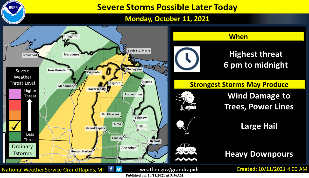
Severe storms will be possible today, with the highest threat from 6 pm to midnight. A few storms will be possible this afternoon toward Ludington. The main line will come in this evening. The main threats will be damaging winds, large hail, and heavy downpours.
Forecast Discussion
- Warmest day the rest of this week is TODAY

With the strong fall storm cominig through the area today, we
will have deep mixing. That will cause it to be breezy and allow
our afternoon temperatures to reach near 80 degrees over most of
our CWA. Temperatures this warm will likely not occur again the
rest of the month.

It seems to this forecaster we are now seeing some significant
changes to the longwave pattern over North America. That will
result in cooler temperatures next week.  I am still not thinking
anything really cold, just a return to near normal.

We currently have a deep western trough and eastern upper ridge
over the CONUS. Currently there is a strong zonal jet crossing
the north Pacific above 50N. This continues to load the western
trough over the past week with shortwaves through this week. That
upper air pattern has given us a series of storms, the one today
is just one of these systems. We have one more to go, late in the
week. By the end of this week, a system coming off eastern Asia
(China and Russia) is strong enough to buckle the flow so it will
no longer be zonal over the north Pacific. That causes the Western
trough to retrograde off shore into the eastern Pacific. That in
turn retrogrades the eastern upper ridge which will be replaced by
a developing eastern trough. This retrogression of the upper wave
pattern over the northern hemisphere will start bringing colder
air south into this area with a series of cold fronts next week.
So, if you have been enjoying this unusually warm weather for mid
October, you have the rest of this week, then what would be more
typical finally for mid to late October will come into Southwest
Michigan. That would be highs in the 50s and 60s and lows in the
30s into the 40s.

- Stormy evening / mostly west of US-131

We are still expecting strong to severe thunderstorms this evening
as previous recent discussions have suggested. However, as we get
closer to the event more details become clear. In this case it now
seems the severe threat is mostly near and west of US-131 late
this afternoon into early this evening (see SPC Day 1 disccusion).

We will get two lines of storms coming through this area, this
evening. It is the first line, late this afternoon into early this
evening that will have the strong storm. The second line early
tonight will likely be mostly just rain showers.

The first line of storms is associated with the upper level jet
core, crossing this area. That line will have decent instability
(1500 to 2000 j/kg of MU cape) to work with and there is a 30 to
35 knot low level jet (near I-75 actually) and 35 to 40 knots of
effective deep layer shear helping the cause. This is the line
that will have strong to severe storms with it. As was pointed out
in prevoius discussions, it will have unidirectional speed shear
with it. We expect linear storms to be the primary storm mode.
However we do have a problem with this event. The system at mid
and high levels will be weakening as it moves into the area toward
evening. The jet core from 500 to 300 mb loses around 20 knots of
wind between 8 pm and 11 pm. Also the MU/ML/Surface based capes
all plummets as this is happening. Also the jet`s left exit
region lift area is over our CWA at sunset but it is over
Northwest Lower Michigan by 11 pm this evening. That will cause
mid and high level subsidence behind it . That would mean mid
level sinking air late this evening over our CWA. All of this
leads me to believe, and this is shown by all of the high
resolution models, that the strongest storms will be early this
evening over the western CWA. Those storms will struggle to get
east of US-131 before 10 pm. Mostly because they will be tracking
north northeastward. By the time they would get east of US-131 the
instablitiy will largely be gone. Hence the real severe storm
threat is near the lake shore late this afternoon into early this
evening.

Expect individual storms to be racing to the north northeast
around 40 to 50 knots this evening. Some large hail is possible
under the stronger updrafts as there is 400 to 600 j/kg of hail
cape and mid level lapse rates are near 7c/km. Damaging winds are
possible from those stronger storms too. An isolated QLCS tornado
is not out of the question. The storms will be moving fast but
rainfall may still locally be has high as a 0.75". The highest
amounts are expected to be near US-31 north of Holland.  It would
seem the flooding threat is fairly low since the storms will be
moving so fast.

The second line of storms is caused by upper trough coming
through. That has the best low level jet support (40 to 50 knots)
but there is very little cape left for that line to work with.
Also we have the issue of upper convergence (above 700 mb) which
will not be overly storm friendly. So that second line will happen
but it will be much weaker since it will lack strong cape to help
it`s cause.

This system is a decent upper level closed low that is being
kicked northeast by a much stronger upper wave downstream of it.
It will remain a cutoff low through Tuesday. That means we will be
in the cyclonic wrap-around flow of it into mid afternoon on
Tuesday. That will mean showers (mostly rather light) during the
day time on Tuesday.

- Brief break in stormy weather Wednesday

We get a brief break in the stormy weather Tuesday night into
Wednesday morning. That is thanks to a shortwave ridge between the
departing system and the incoming much larger system. This next
system is a little more complex then that previous three system we
have seen since early last week.

This will mean some clearing Tuesday night but once again, there
is not a lot of cold air behind this system so lows will only be
in the 50s, which is around 10 degrees warmer than normal.
Wednesday will start off sunny but clouds will move in by
afternoon. Highs should get into the lower 70s even so.

- Showers Thursday into Sunday and turning cooler

That 140 to 150 knot jet core crossing the Bering sea will be the
will force the western trough east and bring us a prolonged rain
event. As that jet digs into the western trough it forces another
strong fall storm to deepen and race north toward the Canadian
border over eastern North Dakota late Wednesday. That pushes
another warm front/cold front event at us. We will get showers
from the warm front and the cold front. However, that 150 knot jet
creates another system. That causes a wave on the cold front even
as is coming through the area just south of us by Friday. That
surface low heads toward Michigan bringing rain for Saturday.
This time through there is COLD AIR! So we then get lake effect
rain showers and it turns colder (really near normal) by Sunday
into Monday.

I do believe we will see SOME rain every day (midnight to
midnight) this week in our CWA. Tonight, western sections will
have the heaviest rainfall of the week. It could be really wet here
through Thursday/Friday/Saturday depending on the track of the
surface low and how the warm front passage plays out.
Had wind, rain and a good amount of lightning and some thunder here about earlier not really severe but it was one of the better storms of this year. It dropped just 0.24″ of rain. At this time it is cloudy here and now it is down to 64. At the airport it is down to 63 and wind gust of 47 MPH was reported there.
Slim
Our wet Fall keeps rocking!
Yep…if you’re West of Ada…enjoy.
One quick gust, followed by light rain. A few flashes and quiet thunder. “Ya take what cha can get around here”.
I’ve got news for you, Ada will be picking up some substantial rain! Get prepared!
Non stop thunder and lightning and rain here.
* Severe Thunderstorm Warning for…
Van Buren County in southwestern Michigan…
* Until 815 PM EDT.
* At 725 PM EDT, severe thunderstorms were located along a line
extending from Benton Harbor to Cassopolis, moving north at 50 mph.
With temperatures up near 80 and dew points in the upper 60’s it is indeed a warm and somewhat humid day for October. The current temperature here at my house is 80 and I have a dew point of 70. The official high for Grand Rapids looks to be 79 so that will be a tie for the 4 warmest reading for the date. The record is 85 in 1928 and in 2nd place is 82 in 1938 a high of 80 happened in 2011 and 2010, 1973 and 1893 a high of 79 was reported in 1962 and 1943.… Read more »
Storms?…fading, fading, fading…nope, not our weather, as usual.
5 months summer, 4+ months of transition weather, 2-3 months of true winter. That’s how things have been playing out lately, and that works just fine for me.
New records for the warmest minimums were set at Grand Rapids and Muskegon for yesterday October 10th the low at Grand Rapids of 64 yesterday set a new record for the warmest minimum for the date at Muskegon their low of 65 also set a new record. At Holland their low of 67 is the new 2nd warmest minimum for the date 70 in 1949 is the record. At Lansing their low of 64 is the new 3rd place warmest minimum their record is 67 in 1879 and in 2nd place is 65 in 2018.
Slim
After new record warmest minimums were set for October 10 the over night lows for today have been even warmer. At Muskegon the overnight low was just 72 If it stays above 63 until midnight today would set a new record. At Holland the overnight low has been 69 (it was in the low 70’s most of the night) it would have to stay above 67 until midnight for a new record there for today. Here at my house and at GRR the overnight low has been 67 It would have to stay above 65 until midnight for a new… Read more »
We have basically had 5 straight months of summer-like weather. Around the middle of May up until the middle of October. And no signs of any cold air the rest of this month.
I believe Bill mentioned he thinks December will be the coldest in at least 4 years (not his official forecast, just a comment he made). He made that comment when talking about the high Siberian snow cover. So things could change eventually… but for now we are still stuck in this warm pattern.
Through the first 10 days of October, GR is +10.6 degrees above average. I love long summers!
Geomagnetic storm warning for today. They’re pretty confident this CME will be a direct hit on earth.
70 degrees at 4:30 this morning, 26 degrees above the average low. That is an incredible departure from average!
While no new record highs have been set there now have been several record and near record warmest minimums set in this month.
Slim