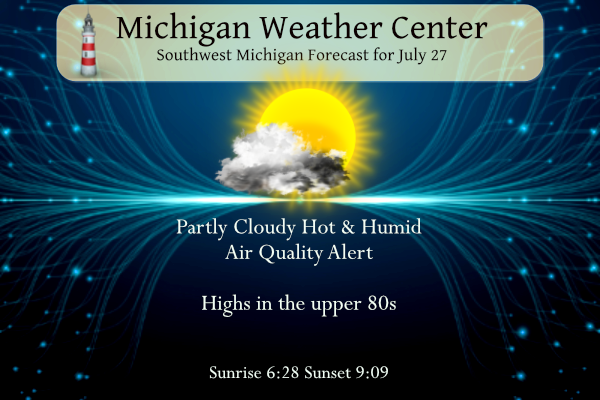
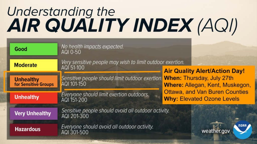
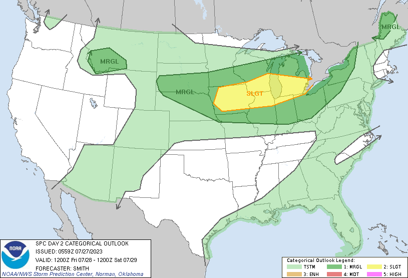
Yesterday was warm and wet, we managed another .63 inches of rain in Otsego which brings us to 2.29 inches for the month and 3.13 inches for the summer (since June 1st). Today will be hot and humid with temperatures near 90°. There is an air quality alert for the lakeshore counties and Kent County in place for today. Tomorrow will bring another chance of severe storms.
Grand Rapids Forecast
7 27 grrSW Michigan Weather History
July 23
1883: A half-mile-wide violent tornado killed three people as it moved southeast from near Eaton Rapids to south of Leslie.
1999: Severe weather struck central Lower Michigan, with two weak tornadoes touching down in rural areas. One struck near Mount Pleasant, but only lasted a few seconds and produced no damage. Another brief touchdown was reported during the early evening hours in Tustin, in Osceola County, where it produced minor damage to one home.
July 24
1934: Extreme heat continues for the fifth consecutive day with Lansing equaling their all-time high temperature of 102 degrees. Grand Rapids hits 103 degrees, part of a string of five out of six days at or above 100 degrees there.
July 25
1943: The USS Muskegon, named after the Michigan city, is launched from Superior, Wisconsin on a day with scattered showers and a high temperature of 86 degrees at Muskegon, Michigan. The ship saw duty in World War Two, escorting convoys across the Atlantic. The ship also took weather observations and served as a radio and light ship for trans-Atlantic flights until after the end of the war.
2005: An extended round of severe weather from the evening of July 25th into the morning of the 26th produced widespread wind damage across Lower Michigan. A tornado struck three miles west of Baldwin and downed hundreds of trees at a campground. Fortunately, most of the campers had left just hours earlier, and there were no injuries.
July 26
1896: A tornado struck a few miles northeast of Battle Creek, seriously injuring one person as it destroyed a farm home and barns in Pennfield Township, Calhoun County.
1973: A tornado damaged a mobile home and some farm wagons two miles southeast of Clare, Michigan.
1977: Canadian high pressure brings record cold temperatures of 46 degrees at Muskegon and 47 degrees at Grand Rapids.
July 27
1894: The temperature hit 100 degrees at Lansing during the second record heat wave of the month, the first of which occurred a week earlier, when Lansing set its all-time record of 102 degrees
1955: Temperatures reached the upper 90s for the second day in a row across West Michigan in one of the hottest months on record. At Grand Rapids, 15 days had high temperatures above 90 degrees during July 1955.
2002: A severe weather outbreak produces tornado and downburst wind damage. A tornado with top winds around 80 mph touched down about one mile east of Augusta in Kalamazoo County. The tornado passed through Fort Custer in western Calhoun County, about one-mile northwest of the Battle Creek airport. The damage path was approximately 800 yards wide and the path length was 3 miles long. Extensive tree damage occurred in the Fort Custer area and the roof was blown off a firing range shelter. After the tornado ended, downburst damage continued for several more miles in Calhoun County. A severe thunderstorm struck a campground and mobile home park along Swan Lake in southern Allegan County. Trees were blown down onto mobile homes and small boats were blown out of the lake. Two minor injuries occurred. Top winds with the downburst were estimated at 70 mph.
July 28
1959: A steady rain brought relief from drought conditions across West Michigan. Dry weather began in April, resulting in water rationing in Grand Rapids by the middle of July.
1976: A tornado injures five people northwest of Grand Rapids as it damages a warehouse.
1996: A weak, short-lived tornado damaged a pole barn near Evart in Osceola County.
July 29
1916: Temperatures soared to record highs as a ten-day heat wave reached its peak. The 102 degrees at Lansing would tie the record for the hottest day ever there. Grand Rapids hit 103 degrees as part of a record string of four consecutive days of 100 degrees or higher. Even the Lake Michigan shore was baking, with Muskegon hitting 95 degrees.
South East Michigan Weather History
July 23
On July 23, 2010, severe thunderstorms moved through areas along and south of I-94. The strongest storm produced a measured 82 mph wind gust near Whitaker. That storm also produced an EF0 tornado along Judd Road between Hitchingham and Whitaker Roads. Maximum estimated winds with the tornado were around 80 mph, with a path length of 0.6 miles and a width of 100 yards.
Also on July 23, 1999, Detroit experienced up to 70mph wind gusts with a strong storm that moved on through.
July 24
On July 24, 2021, a line of strong to severe storms moved across all of Southeast Michigan, producing widespread damaging wind gusts and four tornadoes: 1 EF0 in Port Austin and 3 EF1s in Clayton Township, White Lake Township, and Armada. The White Lake tornado occurred just 2 miles south of the NWS Weather Forecast Office and one person was injured in this storm when multiple pine trees fell onto a home. The White Lake and Armada tornadoes formed at the same time, at 7:54 pm. The last time four tornadoes struck Southeast Michigan in one day was March 14, 2019.
On July 24, 1934, the temperature soared to 105 degrees in Detroit. This is the highest all-time temperature recorded in Detroit.
July 25
On July 25, 2017, the low temperature fell to 47 degrees, tying the record low temperature for the date originally set in 2013.
On July 25, 1986, Genesee County reported an F1 tornado at 5:05 p.m. that caused 1 injury and 25 thousand dollars in damages.
July 26
On July 26, 2012, training thunderstorms produced a band of torrential rainfall and some severe weather mainly north of the I-96 corridor. Despite strong winds downing some trees and power lines north of I-69, the main impact was heavy rainfall, including a 2-day (July 25-26) total swath of 1″ to 2″ across the Saginaw Valley
On July 26, 2007, numerous reports of large hail occurred with storms that blew up in the very unstable air mass over Southeast Lower Michigan. The worst of these storms hit eastern Shiawassee County (around Durand) and further south in Lenawee and Monroe counties (in and around Adrian, Petersburg, and Samaria). Hail up to the size of golf and ping-pong balls were seen in a few of the worst storms.
July 27
On July 27, 2014, an atmosphere ripe for the generation of large hail erupted over Southeast Michigan resulting in widespread severe weather. Numerous reports of wind damage and heavy rainfall were received. However, it was the significant hail that made this event unique. Hail reached 2.5 inches in diameter just north of Milford in Oakland County and 3 inches (larger than a baseball) in Bay County.
Also on July 27, 1928, 3.07 inches of rainfall fell in Saginaw. This is the precipitation record for the month of July in Saginaw and is also greater than the average amount of precipitation Saginaw receives for the entire month of July (2.50 inches)! Also in 2004, temperatures hovered in the mid-50s to 60s as a steady rain fell. The record low maximum of 64 (which occurred just after midnight) broke the old record of 70 degrees set back in 1874.
July 28
On July 28, 2011, intense thunderstorm rain from about 2 a.m. to noon, led to rainfall totals of 3 to 7 inches which led to flash flooding across Shiawassee, Genesee, Livingston, Oakland, Washtenaw, and Wayne Counties. Some of the heavier rainfall totals included 5.5 inches in Goodrich, 6.26 inches in Ypsilanti, and 6.5 inches in Chelsea.
On July 28, 2010, severe thunderstorms developed over Metro Detroit. Among the 15 wind and wind damage reports was a measured wind gust of 73 mph at Selfridge ANGB.
Also on July 28, 2000, thunderstorms brought 3/4-inch hail to Livonia and flash flooding to Detroit.
July 29
On July 29, 2000, thunderstorms brought flash flooding to Detroit. Rain amounts were 2.92 inches of rain.
Forecast Discussion
.SHORT TERM...(Today through Friday)
Issued at 352 AM EDT Thu Jul 27 2023

Quiet weather is expected today compared to yesterday`s storms and
storms that may develop on Friday. The day will start out of
stratus and fog. As expected, stratus has been expanding, but
visibilities have not gone completely in the tank. That is likely
due to 15-25 knot winds off the deck in the BUFKIT profiles. Winds
aloft of that magnitude in the 1000-2000ft layer promotes more
stratus and does not allow radiational cooling to be maximized.
So, for now based on observations and the wind aloft will not be
issuing dense fog headlines this morning. We will be monitoring
closely and if enough 1/4SM fog shows up we can issue as its
developing. The remainder of the day, once the stratus burns off
by mid to late morning will feature plenty of sunshine and high
temperatures in the mid 80s to around 90.

Tonight the focus will begin to shift to thunderstorms. The upper
pattern is very much dominated by an expansive ridge over central
and southern portions of the lower 48. Across the northern tier a
zonal flow is in place. Two shortwaves are to be watched in the
short term, the first is in Wyoming tonight and slides into our
area late tonight, the second is moving from California into
Nevada which affects our area on Friday. Both shortwaves are
expected to touch off showers and thunderstorms.

The first wave for tonight brings showers and storms into area
northern and western CWA late tonight and into Friday morning.
Given the time of day (late at night) and a weaker somewhat
disjointed low level jet we are not expecting severe weather
through 12Z on Friday. The 4 hour max reflectivity off of the HREF
shows much of the convective activity will remain over the lake
tonight. A couple MCS`s will be working our direction in a
decaying mode. So, we can see possibly having to monitor some
residual outflows working our direction after 08Z tonight.

On Friday the second shortwave moves our direction and will have a
boundary likely set up across the area to work with. Not the
greatest setup during the day on Friday for severe weather with
what could be clouds and showers around in at least the morning.
The better threat will likely hold off until the Friday
evening/night period which is addressed below in the long term.

As for now we are holding off on any heat headlines for Friday in
our forecast area given the threat of clouds and precipitation
affecting heating on Friday. This could change going forward if
Friday looks to be more clear with better heating taking place. As
for now we have heat index values in the 90s, with is below the
100 threshold for a heat advisory.

.LONG TERM...(Friday night through Wednesday)
Issued at 326 AM EDT Thu Jul 27 2023

Friday night will likely be another active period as a quasi-
stationary front is progd to be draped east-west just north of I-94.
Generally westerly flow aloft will see a minor short wave move east
from the Plains toward the Great Lakes with corresponding
thunderstorm development beginning Friday. Storms will likely be
ongoing by 00z Saturday as strong instability and plenty of moisture
will be in place. In fact, precipitable water values are progd to be
near 2.25 inches Friday evening, suggesting a heavy rain threat.
MUCAPE near 1k j/kg, bulk shear in the 35-45kt range and a
strengthening LLJ point toward convective organization and a
potential severe threat. SPC has placed most of the cwa in a slight
risk for severe storms. DCAPE values are not quite as high Friday
evening across the cwa as they were yesterday due to less dry air
available below 700 mb. However the thought is that a cold pool
driven MCS along the frontal boundary may be enough to produce
strong wind gusts. Once the frontal boundary moves south Friday
evening, the precipitation will go with it.

A large area of high pressure over the northern Plains will build
southeast toward the Great Lakes over the weekend and into next week
producing dry weather for much of the period. Highs Sunday and
Monday will be mostly in the 70s with lows in the 50s.

Another cold front moving south Wednesday night/Thursday may produce
more showers/storms.


Feels like the hottest day of the Summer sofar outside open my truck wanted to puke lol.. lets get back to the uper 70’s and lower 80’s thank you!! severe weather tomorrow is forecast could get interesting around here again but the timming is a little off but we will haft to moderate it for sure all ready Enhanced area for Minnesota…Stay tuned….INDY
I went down this late morning to the area where that tornadic video was filmed a sure enough there is damage down in that area primarily in the form of trees although I did see a damaged barn. The trees are sheered off clean in one area. No doubt I think it was a weak tornado maybe high end EF0 or low end EF1. This area of damage is in extreme northern Jackson County about a mile or so north of the community of Munith. I have sent the pictures to NWS GR. Those that have me on FB you… Read more »
Thanks for passing to tornadic video along Mark I sent it to the NWS in Grand Rapids and they sound as if they didn’t know this video existed and were unaware so they now have been notified about it.
Sometimes I wonder how many tornadoes go unnoticed (especially any quick spin-ups yesterday). Good thing we have the internet to pass this information along
Agreed. Back in the day I’m sure many many tornadoes went unreported.
Drought update this week shows no change from last week. Again, this excludes the rain from yesterday.
https://droughtmonitor.unl.edu/CurrentMap/StateDroughtMonitor.aspx?MI
I am surprised they didn’t downgrade some abnormally dry areas to normal. But it is hard to get out of a drought, especially since we were so dry for so long. The spotty nature of the rain doesn’t help either. For example, my house got >0.2” and 15 minutes north got <1.5”.
GR is above normal for seasonal rainfall this year ! Incredible!
Sure looks like a tornado to me
https://www.wilx.com/2023/07/27/watch-possible-tornado-spotted-near-stockbridge-wednesdays-severe-storms/
That sure looks like one to me as well.
Slim
There is no doubt that is a tornado. Great to see someone captured something. The rotation on radar was very tight near Stockbridge.
The official H/L at Grand Rapids yesterday was 80/66. Officially there was a reported 1.15” of rain fall. Here in MBY there was much less rain fall with just 0.14” falling. There was a reported 32% of possible sunshine yesterday (I think it was much cloudier here in MBY) The highest wind gust was 26MPH. Most of the severe weather reports from yesterday were in the SE area of the state and here in west Michigan it was mostly rain that fell yesterday. For today the average H/L is 83/62 the record high of 101 was set in 1916 and… Read more »
Today and Friday look to be a warm days with highs in the upper 80’s and lows in the upper 60’s There is a chance of more rain with maybe some thunderstorms on Friday. Then cooling down for a several day string of pleasant days with highs in the upper 70’s to low 80’s. At the current time it is 69 here in MBY with a dew point of 67 here with cloudy skies.
Slim
Still no heat waves are in sight and the pattern keeps rocking!
As you said not “heat waves” at this time. But rather typical summer weather.
Slim