Pretty much the whole state of Maine has snow warnings in place for up to two feet of snow and winds up to 35mph. When I lived out there in the 1970s nor’easters didn’t seem to be a big deal with the exception of having to dig out driveways and plank over the snow the roads were always plowed – never had snow days for the schools. Of course the plows were bigger and the towns and cities had blowers mounted on their trucks. Keep in mind that Maine is mostly wilderness so the road system isn’t even close to what we have here in Michigan. When I lived out there our winter snowfall was generally over 240 inches in the highlands – when I moved back to Michigan winters here were no big deal with our 60 to 90 inch winter totals.
 I drove down to Center Avenue in Kalamazoo yesterday afternoon – the heaviest snow had set up near I94 and visibility was about a quarter mile, other than that we had light snow and sun most of the way there and back.
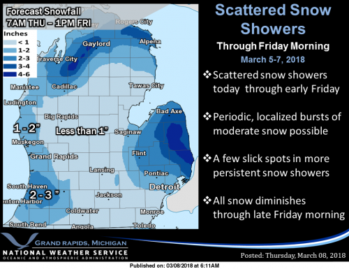
Low pressure will continue to spin across eastern Lower Michigan today bringing some light snow along with scattered lake effect snow showers which will linger into Friday. High pressure will build in for the weekend but another clipper will arrive early next week with a chance for light snow.
Bittersweet is making snow this morning (image above) – their site says they will be open today…..
I am not seeing any real big warmups until mid-month and that may be brief. Both the GFS and CFS continue to show cooler air in place most of the month and maybe into April. Of course these are only guesses so we will have to wait and see.
Don’t forget the Spotter Training on Saturday in Shelbyville – I will have the maps and info here tomorrow…
Winter is far from over and we will see SNOW near the end of March and the beginning of April, but the warm weather fanatics want to wish winter away! Meanwhile I get out and enjoy the COLD and SNOW! What a concept! INCREDIBLE!
So good, near average thru the weekend only 2 days of really below average next week and then upper 40s to around 50 by next weekend! I can live with a few days of Winter Misery for that, no biggie!! Might be fun to throw a death of winter party next weekend, to celebrate the departure of it’s horribleness!!
http://wx.woodtv.com/weather/8forecast_640x480.jpg
GR is up to 71 inches of SNOW the year already with TONS more yet to come! FANTASTIC!!!!!!
Skiing here I come! Winter Wonderland baby! ROCK n ROLL will never die!
You gotta love this from the GR NWS! Bring it on!
The air I expect we will see is significantly colder than
the air we are currently forecasting. Highs are more likely to be in
line with the ECMWF model (28 on Tue and 28 on Wed.) Lows will
likely be much colder too (18 Tue. and 4 Wed.).
Another aspect to this is that the polar jet will be south of us
during this time so lake effect snow is likely and I would expect
some accumulation.
Next week we see highs in 20’s! INCREDIBLE March cold!
Cold for the next 10 days .. bring on the 50’s and 60’s yeaaaa! INDYDOG14!
Well, cold for next 5 days or so….
https://weather.com/weather/tenday/l/USMI0344:1:US
Oh wait…
http://www.cpc.noaa.gov/products/predictions/610day/610temp.new.gif
Yep…lousy, cold March, April, and most of May. Forecast in 2017…”Winter long, Spring none”.
Today’s CFSv2 is hinting colder and dryer for the rest of March
week 1/2 temperatures
http://www.cpc.ncep.noaa.gov/products/people/mchen/CFSv2FCST/weekly/images/wk1.wk2_latest.NAsfcT.gif
week 1/2 pricp
http://www.cpc.ncep.noaa.gov/products/people/mchen/CFSv2FCST/weekly/images/wk1.wk2_latest.NAprec.gif
week 3/4
http://www.cpc.ncep.noaa.gov/products/people/mchen/CFSv2FCST/weekly/images/wk3.wk4_latest.NAsfcT.gif
week 3/4
http://www.cpc.ncep.noaa.gov/products/people/mchen/CFSv2FCST/weekly/images/wk3.wk4_latest.NAprec.gif
Yesterday was (barely) GR’s first below average day in over 3 weeks! It was a tremendous mild run. It looks like the brief minor cool down continues for a few days before it’s back into the 40’s.