
Christians celebrate Easter as the day Christ rose from the grave. Looking at history I found the celebration of Easter predates the Christian area as a festival celebrating spring. We can celebrate both today as we will see sunny skies and warm temperatures in the 60s. Temperatures will rise into the 70s by midweek and it appears spring is here to stay around. We have already cut some daffodils last week to bring a taste of spring inside.
Today is the 60th anniversary of the first documented case of a tornado detected by radar. Water Survey staff, at Willard Airport in Champaign, IL, captured the historic event on film on April 9, 1953. This discovery helped lead to the first national weather radar network in the United States.
The radar was located at Willard Airport, south of Champaign IL, and was being used along with a rain gauge network to relate radar signals with rain rates. Don Staggs, the radar technician, had stayed late to complete repairs on the radar. While testing the repairs, he noticed an interesting radar return and began recording the radar scope using the mounted 35 mm camera. As a result, he captured a well-defined hook echo on film. See the photo below. The hook echo is best described by the National Severe Storm Laboratory:
A “hook echo” describes a pattern in radar reflectivity images that looks like a hook extending from the radar echo, usually in the right-rear part of the storm (relative to the motion of the storm). A hook is often associated with a mesocyclone and indicates favorable conditions for tornado formation. The hook is caused by the rear flank downdraft and is the result of precipitation wrapping around the back side of the updraft.
Afterward, researchers related the radar data that Don recorded to detailed damage reports along the tornado’s path (see map and photos below).
The 1954 Water Survey report on the tornado stated, “It may be possible to establish radar storm warning systems in tornado areas to reduce loss of lives.” The April 9, 1953, event, along with subsequent events, helped provide the push in the US for developing a nationwide network of weather radars.

First recorded radar hook echo that was later associated with a tornado, April 9, 1953, near Champaign, IL. Photo by Illinois State Water, Prairie Research Institute, University of Illinois.
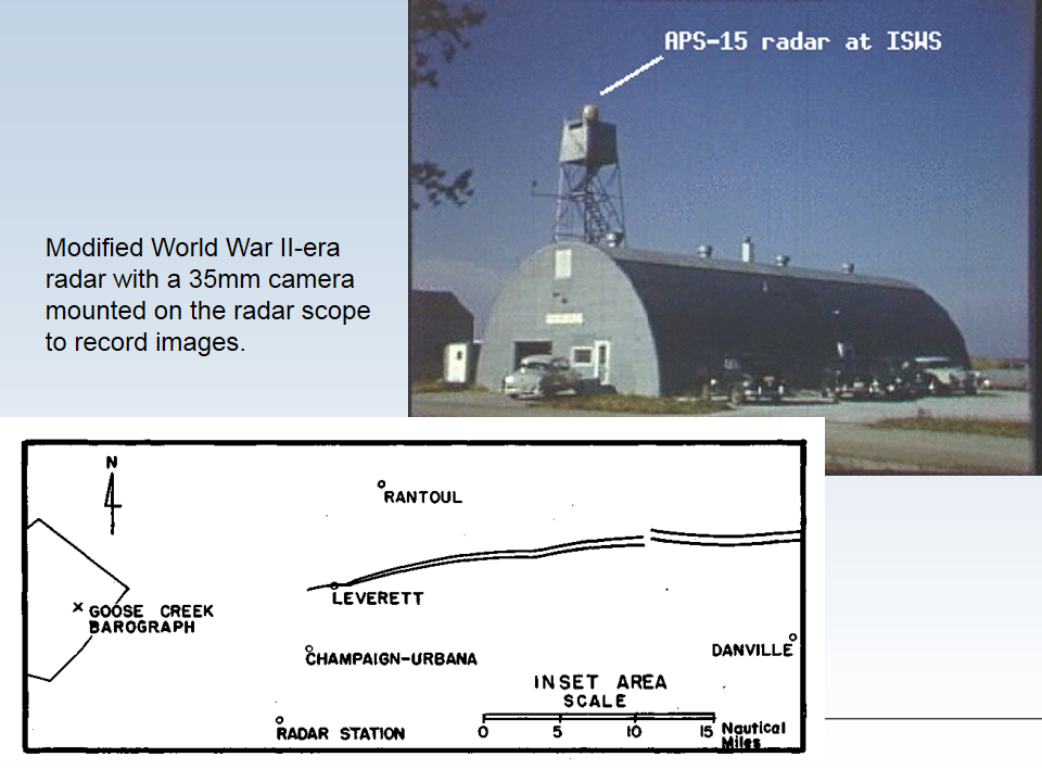
The radar site and track of the tornado on April 9, 1953. The radar station is at the bottom of the map while the tornado passed north of Champaign-Urbana, Illinois. The radar was a highly-modified version of an airborne radar set from World War II.

Damage caused by the April 9, 1953, tornado.
Grand Rapids Forecast
4 9 grrLansing Forecast
4 9 lanKalamazoo Forecast
4 9 kzoForecast Discussion
- Dry and Warm Period

Building upper heights, increasing warmth, and a lack of
precipitation will be featured for the majority of this coming
week. A surface high will establish itself across the SE U.S.
early this week and that will continue into at least mid if not
late week. Surface pressure gradient force through the Midwest
and Great Lakes will be greatest Tuesday into Wednesday. Expect
breezy conditions for both days, with the highest gusts on
Wednesday when over 30 mph will be possible.

Temperatures will steadily warm through the period, with 60s today
into early this week then 70s for mid to late week. Some fire
weather concerns do exist given drying fuels mid to late week
combined with warming temperatures and gusty winds. Min RH values
may drop below 30% across central Lower Michigan especially
Thursday into Friday, when fire weather conditions may be
elevated.

- Next Chance for Rain Holds Off Until the Weekend

Upper troughing will work its way from west to east across the
CONUS this week and should arrive in the Great Lakes by the
weekend. On the leading edge of this trough, low level moisture
advection off the Gulf is noted in the medium range guidance.
Showers and perhaps some thunderstorms could traverse through the
region Saturday into Sunday as a cold front approaches. Expect a
cooling trend to begin late in the weekend and into early the
following week.
HAPPY EASTER EVERYBODY!!! It was a beautiful day!!
Sunny and 66. Wow!
Our warm streak just won’t stop. Here comes the blowtorch!
Happy Easter!
Happy Easter!! Looks like it will be a beautiful day. Enjoys!!!
Nice information on first radar detected tornado.
Slim
Happy Easter! Yesterday was a nice early spring day. With 62% of possible sunshine the official H/L at Grand Rapids was 59/32 there was no rain or snow fall. The overnight low here in MBY so far this morning is 32 and that is the current temperature. For today the average H/L is 55/35 the record high of 79 was set in 1931 and the record low of 18 was set in 1997. The record snow fall of 4.4” fell in 1973. Last year it was s cold 40/30 and there was a trace of snow fall.
Slim