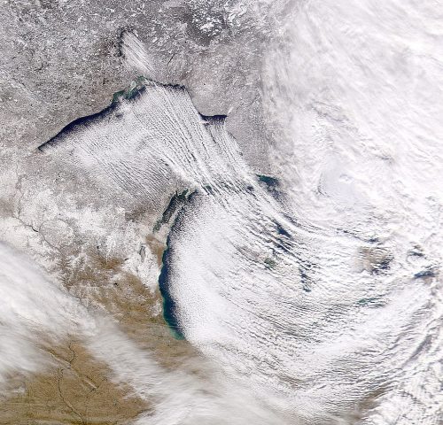
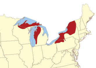
 One thing that is well known especially along the Lake Michigan coastal counties is lake effect snow. When trying to put together a winter forecast for Michigan figuring in lake effect snow amounts is almost impossible for the season. Wind direction and wind speed can create a lot of variability when cold air moves across the lake. There are several other key elements that are required to form lake-effect precipitation and which determine its characteristics: instability, fetch, wind shear, upstream moisture, upwind lakes, synoptic (large)-scale forcing, orography/topography (terrain), and snow or ice cover.
A temperature difference of 13 °C (23 °F) (or as past researchers have estimated: between 15 °C and 25 °C) between the lake temperature and the height in the atmosphere (~1,500 meters or 4,921 feet at which barometric pressure measures 850 millibars (85 kilopascals)) provides for absolute instability and allows vigorous heat and moisture transportation vertically. Atmospheric lapse rate and convective depth are directly affected by both the mesoscale lake environment and the synoptic environment; a deeper convective depth with increasingly steep lapse rates and a suitable moisture level will allow for thicker, taller lake effect precipitation clouds and naturally a much greater precipitation rate.
The distance that an air mass travels over a body of water is called fetch. Because most lakes are irregular in shape, different angular degrees of travel will yield different distances; typically a fetch of at least 100 km (62 mi) is required to produce lake effect precipitation. Generally, the larger the fetch the more precipitation that will be produced. Larger fetches provide the boundary layer with more time to become saturated with water vapor and for heat energy to move from the water to the air. As the air mass reaches the other side of the lake, the engine of rising and cooling water vapor pans itself out in the form of condensation and falls as snow, usually within 40 kilometers (25 miles) of the lake but sometimes up to about 100 miles.
Directional shear is one of the most important factors governing the development of squalls; environments with weak directional shear typically produce more intense squalls than those with higher shear levels. If directional shear between the surface and the height in the atmosphere at which the barometric pressure measures 700 mb (70 kPa) is greater than 60 degrees, nothing more than flurries can be expected. If the directional shear between the body of water and the vertical height at which the pressure measures 700 mb (70 kPa) is between 30 and 60 degrees, weak lake-effect bands are possible. In environments where the shear is less than 30 degrees, strong, well organized bands can be expected.
Speed shear is less critical, but should be relatively uniform. The wind speed difference between the surface and vertical height at which the pressure reads 700 mb (70 kPa) should be no greater than 40 knots (74 km/h) so as to prevent the upper portions of the band from shearing off. However, assuming the surface to 700 mb (70 kPa) winds are uniform, a faster overall velocity will work to transport moisture quicker from the water, and the band will travel much farther inland.
A lower upstream relative humidity will make it more difficult and time consuming for lake effect condensation, clouds and precipitation to form. The opposite is true if the upstream moisture has a high relative humidity, allowing lake effect condensation, cloud and precipitation to form more readily and in a greater quantity.
Any large body of water upwind will impact lake-effect precipitation to the lee of a downwind lake by adding moisture or pre-existing lake-effect bands, which can re-intensify over the downwind lake. Upwind lakes do not always lead to an increase of precipitation downwind.
Vorticity advection aloft and large upscale ascent help increase mixing and the convective depth, while cold air advection lowers the temperature and increases instability.
Typically lake-effect precipitation will increase with elevation to the lee of the lake as topographic forcing squeezes out precipitation and dries out the squall much faster.
As a lake gradually freezes over, its ability to produce lake-effect precipitation decreases for two reasons. Firstly, the open ice-free liquid surface area of the lake shrinks. This reduces fetch distances. Secondly, the water temperature nears freezing, reducing overall latent heat energy available to produce squalls. To end the production of lake-effect precipitation, a complete freeze is often not necessary
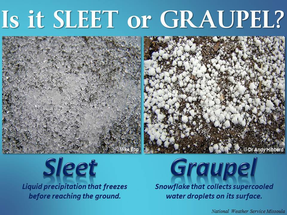 May see a bit of snow today mixed with rain and graupel. Had a period in Allegan yesterday when the graupel was falling during the late afternoon fast and furious. Graupel is soft hail or snow pellets, precipitation that forms when super-cooled water droplets are collected and freeze on falling snowflakes, forming 2–5 mm (0.08–0.20 in) balls of rime. The term graupel comes from the German language.
We will struggle to get to 40° today with precipitation chances around 60%.
Tomorrow and Friday we should see some sun again but this time of year we generally see more clouds than sun especially along the lakeshore counties. We have a chance of reaching 60° Thursday and Sunday. The GFS is showing mid-sixties for November 6th followed by a good shot of cold air with temperatures back in the 30s and 40s.
Tomorrow I will have my preliminary winter forecast for what it is worth. The weather currents are always changing so you will have to take it with a grain of salt and perhaps a shot of Cognac….
Here is the updated CPC’s guess for November 2017
http://www.cpc.noaa.gov/products/predictions/30day/
Slim
This will be the snowiest October 31st in Grand Rapids since 1932 when .03″ was reported. The most snow fall on the 31st is 1.5″ and that was in 1917. Hum does that make this a hundred year event? BTY as for hints for snow on Halloween and the upcoming winter well that is a mixed bag. In 1917/18 Grand Rapids recorded 75.9″ and in 1932/33 that winter GR only recorded 43.6″
Slim
I have been getting a heavy snow shower for the last half hour or so with big flakes and enough snow to cover the ground roofs and tops of the cars. Welcome to the 2017/18 snow fall season.
Slim
The kids were giddy when we saw snow falling outside this morning. Me? Not so much…