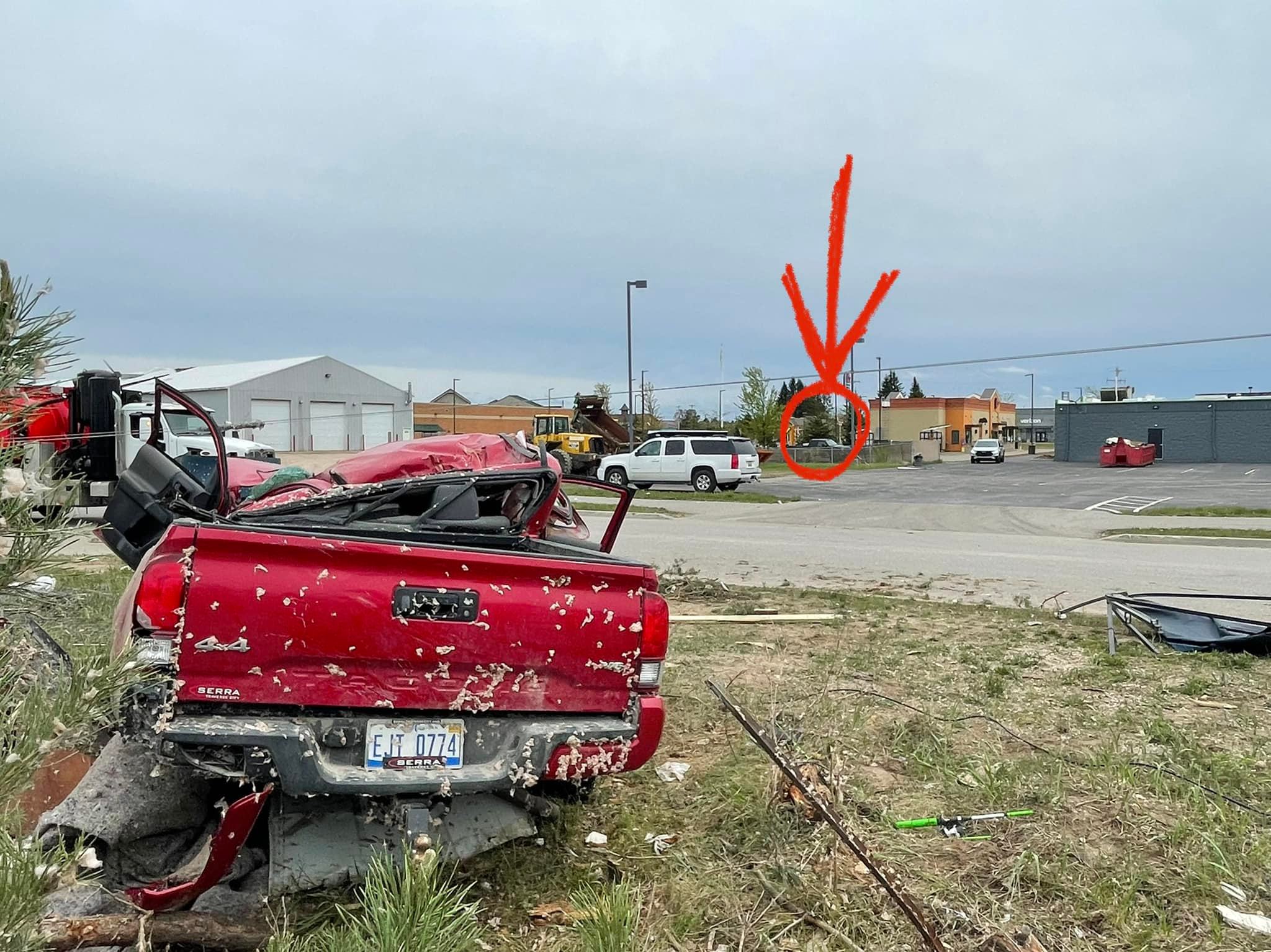
Thanks to Kyle (Portland. Ionia County) for sending me the photos of the Gaylord tornado which he experienced first hand being caught literally in the middle of it. First, this is the Youtube video:
and here are the photos he sent:
[columns] [span6]

[/span6][span6]

[/span6][/columns]
[columns] [span6]

[/span6][span6]

[/span6][/columns]
[columns] [span6]

[/span6][span6]
[/span6][/columns]
The Gaylord Tornado has been rated EF3 – with peak winds of 150 mph. It resulted in two fatalities and 44 injuries (not counting those with minor injuries that were self-treated or were treated by a doctor or nurse at the scene).
I have been through several intense storms but no tornado thankfully. Kyle: “I was inside the tornado in Gaylord. I went storm chasing and was off the main exit just off I-75. I’m thankful to god to be alive. My car was hit with debris and came close to totally flipping the car. I got insane video. It touched down very rapidly and intensified coming into town. I was ducked down in my vehicle and thankfully not a scratch on me. The damage is horrible. The last photo shows how close I was to the most intense part of the tornado. This truck appears to have been thrown and landed right here. the circle and the arrow in the back is where I was in my vehicle. ”
Sometimes tornadoes can form and touch down quickly which can be a very dangerous situation, Kyle was lucky and I am sure was thanking God after the storm departed. Thanks, Kyle for sharing the photos and experience. Stay safe…
We received .03 of an inch of rain overnight. Yesterday’s high/low was 67/55. Our total rainfall for the month is 3.46 inches and the springtime total is 11.65 inches.
Temps will struggle towards 60° today with overnight lows near 40° in SW Michigan. We have freeze and frost advisories for the northern lower peninsula tonight.
Forecast Discussion
...Clearing today, frost possible north tonight...

Latest radar shows scattered showers moving northeast across the
cwa. This precipitation is in advance of the upper trough axis and
once that moves through later this morning, the showers will end. A
large dome of high pressure will then settle over the Great Lakes
and we`ll see the clouds scatter out during the late morning and
afternoon. Today will be chilly. Cold advection will push h8 temps
down to around 0c over the CWA which will result in surface
temperatures a couple of degrees either side of 60 today. Skies will
clear tonight and when coupled with the light winds underneath the
high, temperatures will fall into the mid 30s over the northern cwa.
As such, we have issued a frost advisory for northern portions of
the cwa tonight.

...Mid week storm system...

After a sunny Monday, clouds will increase Tuesday ahead of the next
system. The ECMWF and GFS have been in lockstep for the past few
days with the track and intensity of this low that moves north from
Texas. There will be a strong feed of Gulf moisture with this system
and we could be looking at a widespread decent rain Wednesday into
Thursday; precipitable water values increase to around 1.6 inches
Wednesday thanks to a 45 kt LLJ advecting moisture northward. The
upper low won`t clear the area until next Friday, so showers will
linger in the forecast until then.

A warm front is then progd to lift north Saturday, so we`ll likely
have a mention of precipitation for that.
Went to John Ball today. My wife lost an earring at the treehouse 2 weeks ago at the wedding reception we attended. They found it, fortunately. We really like that zoo. Lots of people today. My face is pink from the sun. The downside is that all the birds are put away due to the bird flu. Fun day, regardless.
Furnace kicked on this morning crazy…InDY
And you will really need it tomorrow! Get ready!
Possible low temps tonight in the 30’s! Wow just wow! Incredible!
With all these below normal temps coming up, I wonder if May will also end up with below normal temps, just like most months this year! Very cold year so far! Incredible cool pattern we are entrenched in!
I just knew we were going into a terrible day with violent storms F3 Tornadoes the set up was heavy Friday lots of damage… This is just the start of a very violent Summer ahead storm track is right over the state of Michigan I saw this coming back in March.. stay tuned everyone and stay safe 🙏 INDY
Yesterdays official H/L at Grand Rapids was 65/54 being further west the cold front came thru GR before Lansing. The high at Lansing was 74 just after midnight. It was yet another example as to why Lansing has seemed to be warmer than GR many times this year. As there have been many times when the cold front came thru just before and just after midnight. The official total rain fall at GR for yesterday was 0.86. The overnight low at both my house and officially at GR was 52 and that is the current temperature. We are taking a… Read more »
Thanks for video and pictures. That was quite the storm thoughts and prayers out for all in Gaylord. While I have not spent as much time there as Kyle has I have been there many times on my way to and from Alpena.
Slim
Thanks for sharing Michael. My thoughts and prayers continue with those impacted up there. Gaylord is a special place for me and hits closer to me because I’ve spent lots of time there.
I’m still shocked that you not only intercepted a tornado, but an EF-3 tornado. And the fact that it was in northern Lower Michigan. You would think Alabama or the plains… not Gaylord Michigan.
And yes, prayers for the people in Gaylord. I pass through every summer when heading up north.
Thanks for sharing your video and photos. They were interesting to see. The people there have alot of rebuilding to do. Keeping them in my prayers. You be safe in your chases.
Thanks for sharing, Kyle and thanks for posting, Michael. Sad situation up there. Lives have been changed forever.
Well, I don’t see any 30s in the forecast this week, so it looks to be not a horrible forecast. I’m playing in a golf outing Wednesday. Usually it’s hot and humid for this event, so this will be a nice change.