
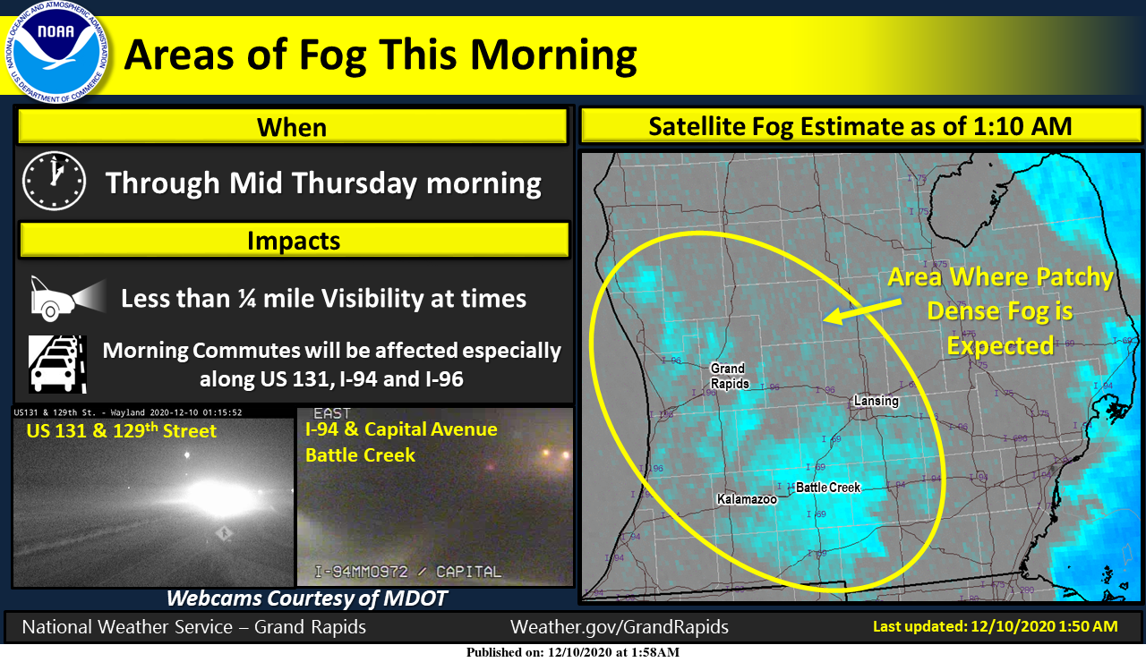
We have a freezing fog advisory for most of lower Michigan until 9 am this morning. This will cause low visibilities and possible slippery areas on the roads especially bridges and overpasses. For those of you who stayed up late last night you should have caught a good light show from the northern lights.
Enjoy the sun today as forecast trends are showing mostly cloudy conditions for the next several days as clouds increase tonight in advance of our next storm system. The track of the storm is still uncertain however we should have a better idea of the track by tomorrow. This mornings models are trending northward.
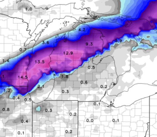
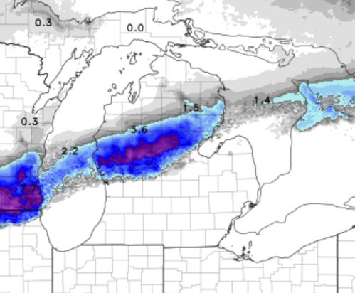
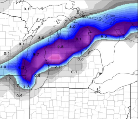
Below is the NWS guess:
Model trends have shown a slightly sooner arrival of the storm
system for the beginning of the weekend. Precipitation should
start falling Friday afternoon and then increase in intensity
through the night. Thermal trends support a slightly northward
trend to the area of impactful snow. The precipitation could be
moderate for a period as the system continues to show a coupled
upper jet...favorable Gulf moisture tap...weakness in the
stability and mid level FGEN.  At this time it appears the
northern 2 to 3 rows of our CWA may see a headline snow event.
This area is generally north of a Whitehall to Alma line. Close
monitoring of the storms development will be needed going forward.
[columns] [span6]
[/span6][span6]

[/span6][/columns]
Snowfall guesses:
[columns] [span4]
NAM
[/span4][span4]
NAMnest
[/span4][span4]
GFS
[/span4][/columns]
As a side note the GFS and GEFS models are showing very little snow through the end of the month, but these are only guesses so we will see.
Hi all. Thought I’d take a minute to check in. My wife has pneumonia. My temp is 102-103 every day. Had a virtual visit with the doc this morning. Going to start a heavy duty regimen of steroids and will reevaluate after ten days. Still feel miserable. Thank God, the kids have been spared the brunt of the virus. I’ve lost nearly 20 lbs. Going back to sleep now. Stay well.
Best wishes for a speedy recovery to you and your family Mark.
And just think Mark, there are still some ignorant people out there that don’t believe it is real and will not wear masks! Unbelievable!
I know, but let’s not go there, okay? We are all Americans at the end of the day.
Agreed!
Take car Mark.
Slim
Thanks for the update Mark! Man, that sounds rough. Feel bad for you guys and hoping it clears up soon!
I hope you and your family feel better soon!! It is a nasty virus!! Take care of each other. Stay safe. Keeping you in my prayers.
53 degrees today after a low of 23
It was a very nice day! I enjoyed seeing the sun today and it didn’t feel cold outside.
Currently 51 degrees! 14 degrees above average.
No big snow and lots more warmth in sight!
Keep the good news coming !
It seems like low pressure storms tend to meander further SE in the models about 1-2 days out, so a SE shift is still possible (I am assuming this is a pressure system, haven’t looked yet).
For the past 2 years the models have trended to the North with snow storms not to the South and with this one we do not have enough cold air in place. Unfortunately it looks like a cold rain.
True, I was referring to the past few systems which were supposed to hit GR and points north, but then moved SE to Detroit, Ohio, and New England.
Good point and the November snowstorm sure did track a little to the SE!
Let it snow let it snow let it snow let it snow let it snow let it snow let it snow let it snow let it snow let it snow let it snow let it snow let it snow let snow let it snow let it snow..INDY
I’m going with the old fashion GFS Rocky bullseye over my area heavy wet snow with wind 4-8 inches possibility of 10 inches get ready now Winter storm watch coming …INDY
Acculess weather gives GR 4 to 8 inches of snow from this system and the GR national weather service gives GR a trace! I have seen Acculess weather do this time and time again, so my money is on the local NWS!
The overnight low both were at my house and at GRR last night was 24. And there was a lot of frost this AM. At this time it is clear and 30 here at my house. The trend at this time is for any snow to be north of the GR metro area this weekend. So while there could be snow to the north do not expect much in our area at this time. This could always change. I stepped out side at just past midnight last nigh and yes there was a good display of the norther lights to… Read more »
The NAM shows a total miss also! Hello SNOW country! Up North here I go! Incredible!
http://wxcaster.com/gis-gfs-snow-overlays2.php?STATIONID=GRR
Here is the latest NAM.
http://wxcaster.com/gis-snow-overlays.php?STATIONID=GRR
FYI – the mid range EURO model has been horrible this year and last winter! One miss after another. I would not trust this model until about 24 to 36 hours before the storm hits! Their storm tracks have been way off and should not be trusted!
Here is the snow map that INDY is referring to. It shows the heavy snow just to the North of GR and unfortunately the Northward trend will continue. GR may not even see and inch of snow from this storm. Another miss.
http://wxcaster.com/gis-gfs-snow-overlays2.php?STATIONID=GRR
Slim, what time did you see the Northern Lights last night? I checked several times but did not see anything. Also, anyone see any updates from Mark and his family?
Northern Lights weren’t very good last night in the US. Very few reports. Tonight could be better.
It was just after midnight. In the far NW sky.
Slim
We kept looking here. The fog rolled in and couldn’t barely see across our street. Any chance of it tonight?
Barry, I was wondering the same about Mark & his family as well!!!
Holly cow the lastest GFS gives my area 4-8 maybe 10.inches of snow Winter storm watches coming get to the storm now and grab more Holly cow we have a winter storm coming ….let it snow let it snow let it snow let it snow let it snow let it snow let it snow let it snow let it snow let it snow let it snow! Lol..INDY
Storm track moving north – surprise! WOOD says no big storms for at least a week after this weekend. The big snow drought continues!
>>>>>Breaking Weather News>>>>>The latest RDB model data shows GGR will miss another snowstorm! Once the pattern officially switches over to cold and snow watch out!
Grrr!
Check out the GFS baby ….INDY