
We are not expecting lake effect snow in the near term, however this feature will explain how the NWS issues watches and warnings when the cold air comes across the great lakes.
Forecasting lake effect snow is a significant forecasting challenge in the Great Lakes during the winter months. There are numerous factors that determine the intensity and location of lake effect snow bands including the available moisture, instability (propensity for the air to rise if forced upwards), wind speed, and wind direction to name a few. One factor that is important with respect to the intensity of lake effect snow is the “fetch”. Fetch is essentially the distance that air must travel from the upwind side of the lake (Wisconsin) to the downwind side of the lake (Michigan). A longer “fetch” enables more warmth and moisture to be added to the air as it crosses the lake and this typically results in stronger lake effect snow bands As for the location of where the heaviest snow will fall over land, wind direction is probably the most important factor.
Wind direction is measured in degrees, as on a compass where 360 degrees is north, 90 degrees is east, 180 degrees is south, and 270 degrees is west. Since Lake Michigan is elongated north-south, and since southwest lower Michigan is on the eastern edge of it, lake effect snow from Lake Michigan will generally occur when the wind has a westerly component to it. Wind with an easterly component will result in lake effect snow remaining offshore of southwest lower Michigan.
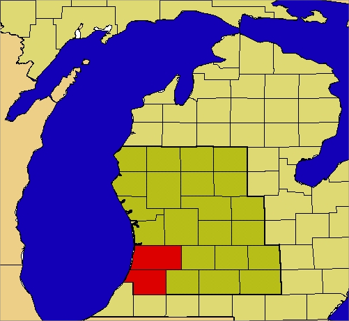
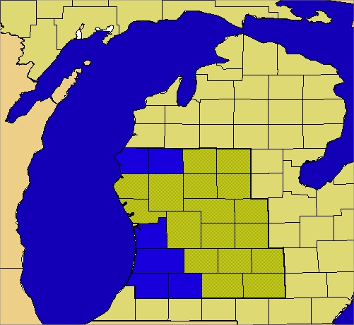
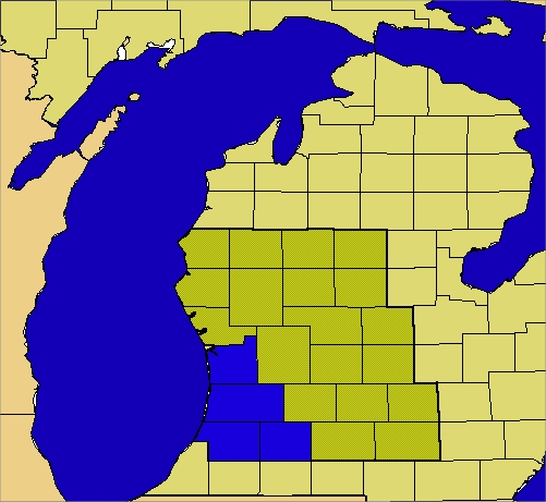
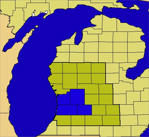
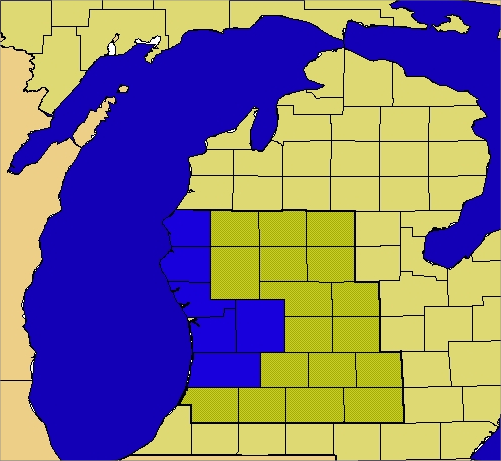
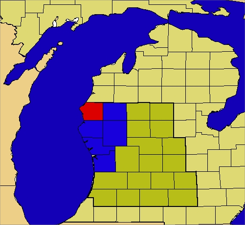
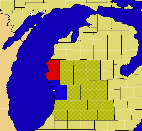
The forecast area of the Grand Rapids National Weather Service office includes the stretch of Lake Michigan shore from near Ludington to South Haven. This discussion will focus on the impact of wind direction on the location of lake effect snow bands between these two locations. Research has shown that the prevailing wind direction will affect the location of the heaviest lake effect snow that occurs along specific areas of the coast and the adjacent inland areas. To examine where the heaviest snow will fall under different prevailing wind directions, we will begin from near northerly flow or 360 degrees, and then transition to near southerly flow or 180 degrees. The maps below are color coded to indicate the threat that a particular county would have for heavy snow for a given range in wind direction (with the assumption that other indicators are favorable for the development of significant lake effect snow). Counties highlighted in red would have a significant threat for receiving heavy snow for the given wind direction while counties colored in blue would have a moderate threat.
At near northerly flow, where the wind direction is from 325 to 350 degrees, the heaviest lake effect snow will occur across Allegan and Van Buren Counties. The lake effect snow bands will originate across northern Lake Michigan and may clip Big and Little Sable points in extreme western Mason and Oceana Counties, respectively.The snow bands then come ashore in the area from Saugatuck to South Haven and may affect areas as far inland as Kalamazoo.
When the flow is more northwest, from 305 to 325 degrees, the heaviest snow area is more expansive and includes Ottawa and Kalamazoo Counties in addition to Allegan and Van Buren Counties. This includes Kalamazoo and Holland as well as Saugatuck and South Haven. A separate area further north consisting of Mason and Lake Counties also sees heavy snow, including Ludington and Baldwin. This may be a result of a favorable trajectory for lake effect snow bands that form over Lake Superior to pass over northern Lake Michigan before coming ashore in the area from Manistee to Ludington. This “Lake Superior Connection” can occur in the northerly flow regime as well, but the bands remain offshore of Mason County, or only clip Big Sable Point, as discussed above.
West-northwest flow, from 280 to 305 degrees, typically produces heavy lake effect snow across the same region as northwest flow, except for Lake and Mason Counties, as the “Lake Superior Connection” snow bands will tend to come inland much further north than Ludington. Ottawa, Allegan, Van Buren and Kalamazoo Counties are still affected from the bands that originate across northern or central Lake Michigan.
Westerly flow, from 280 to 260 degrees, typically brings the heaviest lake effect snow to areas from Grand Haven to South Haven and inland to Grand Rapids and Hastings. This is a function of fetch, as well as wind direction. Although most, if not all of the coast from Ludington to South Haven will see lake effect snow with westerly flow, the heaviest snow can be expected to occur where the fetch is greatest. Indeed, a look at the map shows that Lake Michigan is widest adjacent to the areas where the heaviest snow tends to occur.
West-Southwest flow, from 235 to 260 degrees, results in heavier snow falling from Allegan, Ottawa, Muskegon, Kent, Oceana and Mason Counties. The relatively short fetch across Lake Michigan results in the heaviest snow being concentrated nearest to the shore. Among the inland locations, only Kent County manages to see some heavier snow as the snow bands that reach here have a longer fetch across central Lake Michigan.
For southwest flow, from 215 to 235 degrees, Mason County is most favored for heavy snow, with Lake, Oceana, Newago, Muskegon and Ottawa Counties also seeing some heavier lake effect snow. Again the longer fetch plays a role, as the snow bands with the longest time over water will be coming ashore in Mason County.
For southerly flow, from 190 to 215 degrees, Mason and Oceana Counties are most favored, with Ottawa and Muskegon Counties also picking up some heavier snow. Once again, the snow bands with the longest fetch will be providing the heaviest snow. The southerly flow will mean that the snow will be occurring relatively close to the coast. It should be pointed out that the cases with southerly or southwesterly flow are much less common than the northerly or northwest flow cases, as southerly flow will usually occur when warmer air is moving across the lakes, resulting in less favorable conditions for lake effect snow bands to form.
Me on IPad
Slim
43* degrees out at thee YARDofBRICKS NE of GR I’m thinking most people have the furnace running tonight most lol….whoe’s not loving this below normal weather cold yes!!!!….INDY
Rocky and Indy I am sorry to say this but I ordered 4 new tires today at Belle Tire so with that in mind there should not be as much snow fall this winter. Sorry about that for any one who loves a lot of snow.
Slim
I’m about to purchase a new set as well, and the last 2 times I’ve bought new tires the Winter following was well below normal with snow. Makes it feel like a waste of new and good treads.
You will be very happy that you have some new snow tires this winter, because we will be getting plastered with heavy snow!
Lol… it never snows in zeland ….INDY
Still waiting for that frost you’ve been calling for the past 2 weekends. Better luck next month.
Too funny! Many of the warm weather fanatics keep saying we had an easy winter last year? Facts – GR ended up with above normal snowfall last year just like you and I predicted! Incredible!
And you always forget the fact December through late January had virtually no snow which is the prime time for lake effect snow. The result was below normal snowfall for the lakeshore areas.
Just talked with my sis. She’s up in Petoskey and said the color is beautiful right now.
Very breezy today. The rocking chairs on the porch keep setting off our Ring doorbell.
Yesterday it was mentioned that if the skies cleared overnight we would be getting frost. Well the skies were clear from midnight till about 5a.m. yet the temps stayed the same, just under 50. With the outlooks all trending warmer for the rest of the month, we may go through all of October without a frost.
Most locations in Michigan stayed in the 40 last night. There were some 30’s but very few below 32. There looks to be a major warm up around the 20th of this month so yes we very well make it into November with out get below 32.
Slim
Having lived my whole life on the border of where the lake effect usually ends, the one constant most of the time over the years would be difference between the lake effect forecast and what actually happens. Forecasters guess one thing, but what happens and where is quite often totally different. Just a degree or two difference in wind direction can leave one spot with nothing and a half mile away with over a foot. Since I live between Zeeland and Hudsonville but work in Zeeland, there are many times where there will be next to nothing by our house… Read more »
I will agree that the heaviest of the lake effect ends about 5 miles inland or so. (It would be different if there were higher hills in our area) but that said the true end of the lake effect is about 20 to 30 miles inland. East of say M 66 there is a very sharp cut off and east of there there is very little if any lake effect snow fall. Here at my house a west or west southwest wind is the best. Note that while GR has a average of around 75″ of snow a winter season… Read more »
Good info MV. One more factor to think about with lake effect snow is elevation. While more so in northern Michigan and the west UP elevation also plays a part in lake effect snow fall amounts. That is why even locations well away from the lakes can get a lot of snow fall such as Gaylord. And with the wind in the right direction even as far a way as part of West Virginia.
Slim
Any post about snow deserves a thumbs up …Thanks MV…We be getting a lot it soon! Have a good Sunday INDY
Sadly there is a 63% chance of above normal temps beginning this weekend… normal highs are in the upper 50s.
I added a new feature – the snow and ice archives since 1997 for the northern hemisphere – enjoy
https://michigan-weather-center.org/snow-ice-archives
Holy smokes, there’s a lot in there!
I agree a lot of maps to look at.
Slim