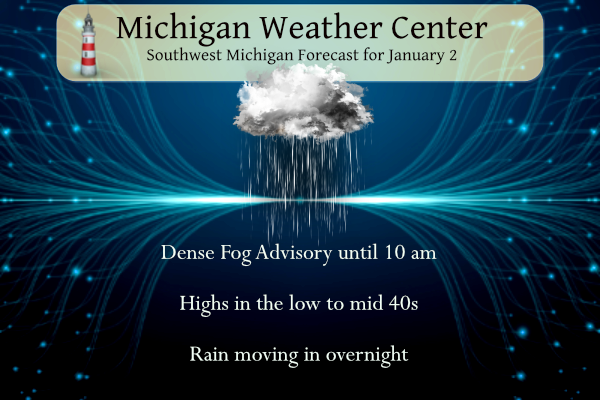
 Yesterday’s low temp was 33° and the high was 43.5°.
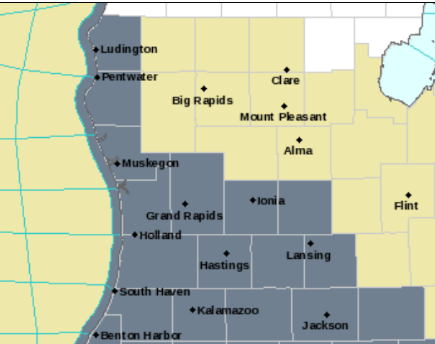
We can expect another mostly cloudy day with a fog Advisory in place until 10 am in the dark-shaded counties. We will move into an unsettled weather pattern tonight through the week with rain chances and perhaps a thundershower tomorrow as temps rise into the 50s to near 60°. Snow showers may return Wednesday night into Thursday as a cold front moves through.
The CPC indicates warmer than normal temps for the rest of January – keep in mind this doesn’t mean we won’t have any snow, we could have some of the wetter denser variety and perhaps freezing rain (heaven forbid).
December Summary
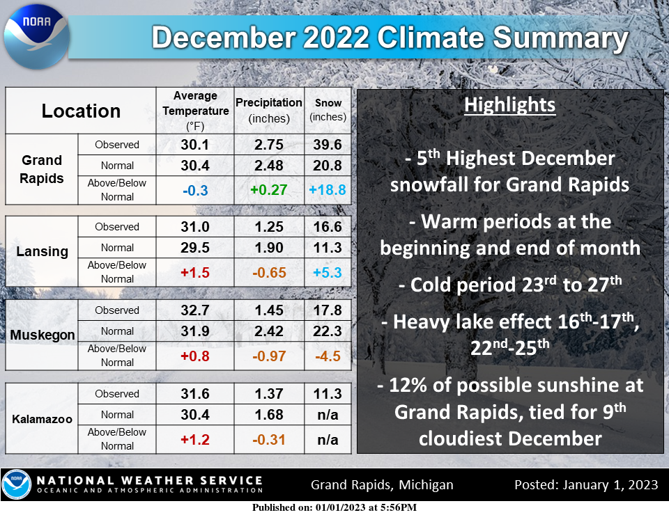
Here is how climate stats ended up for Dec. Temps ended up near-slightly above normal after warm periods at the beginning and end of the month, and a cold period around Christmas. Grand Rapids saw much above avg snowfall with two big lake effect events.
2022 Temperature Departures
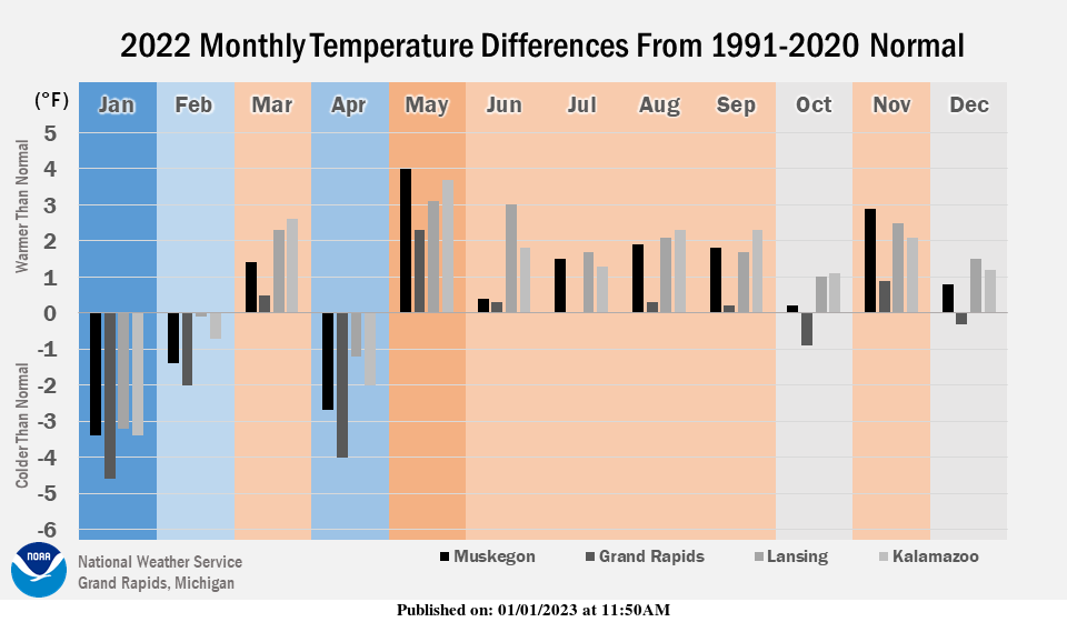
Each month in 2022 has its own story to tell in mid and west Michigan. Of course, there can be big temperature swings within each month that may or may not cancel out. But looking at each month averaged out, January through May had larger departures from the middle, either toward colder or warmer than usual. January was the coldest month relative to normal, and May was the warmest month relative to normal. June through September weren’t overwhelmingly hot but remarkably had “sneaky” persistent warmth compared to other years. October through December had their ups and downs a week or two at a time but worked out to be in the middle to slightly on the warmer side.
2022 Sun Summary
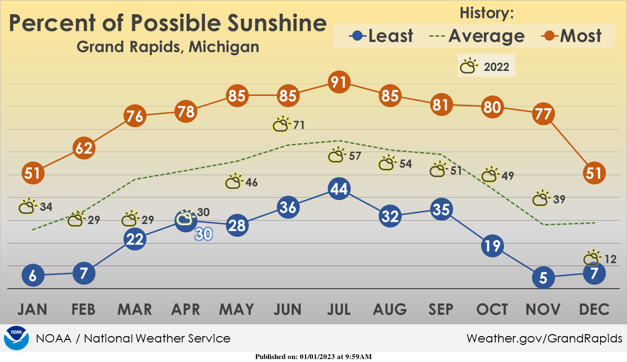
Our relationship with sunshine in Michigan is… complicated. 2022 had its hits and misses. A cloudy spring (tied for the cloudiest April), a spectacular June, a fair July to November, and a very cloudy (but not the cloudiest) December. In December, there were 12 days in a row at Grand Rapids with daily sunshine ranging between 0 and 13 minutes. There were 15 days with no sunshine. Only one day had more than 60 percent of possible sunshine. Other Grand Rapids statistics: The average amount each month ranges between 25 and 30 percent from November to January and increases to 60 to 65 percent during the summer months. During the cloudiest months on record, only 5 to 7 percent of possible sunshine was recorded, and each month between November and February can claim numbers that low during some years. The sunniest months on record have had between 85 and 91 percent of possible sunshine, with May through August being the time of year when that has happened.
Grand Rapids Forecast
7-Day Forecast 42.98°N 85.64°W 1 2 grrKalamazoo Forecast
7-Day Forecast 42.24°N 85.65°W 1 2 kzoLansing Forecast
7-Day Forecast 42.73°N 84.51°W 1 2 lanForecast Discussion
-- Dense fog for the morning commute --

A persistent stream of moisture through the mid and low levels
will continue today and tonight. This has allowed dense fog to
form at the surface. This fog will persist through mid morning and
will at time reduce visibilities to less than a 1/4 mile.

  Looking at the soundings through the region, including models,
There is a deep inversion at the surface, with dry air from 5 to
10Kft and moist air aloft. What this indicates that while there
were break in the clouds earlier Sunday evening, the clearing only
allowed for a cooling and condensing from the moisture at the
surface to couple with the already moist atmosphere to drop
temperatures to the dew point depression. If you couple that
trapped moist air, along with calm winds, then it is a recipe for
fog formation. Along with this there are strong winds
aloft that coupled with the dry 5Kft from around 5kft to 10kft to
create a barrier for the inversion and moisture at the surface.
 For the fog to be able to lift and dissipate the temperatures
will need to warm up to break the inversion so the drier air aloft
can mix down and the air at the cooler denser air at the surface
to lift and then dissipate.

 Temperatures will warm, the question is if it will be able to do
so enough to break the inversion. Some models continue to hang
onto moisture through the morning and into the afternoon. Given
the thickness of the clouds there is this potential, but looking
at the SREF and that the temperatures are already warmer then
models that around 15Z the dense fog should lift enough for
visibilities to increase above a mile. Patchy fog and reduced
visibilities could linger through the day.

--Showers and warmth ahead with storms possible --

The warm frontal boundary ahead of an approaching low pressure
system will move through the Great Plains and begin its trek to
the northeast as forecasted tonight through tomorrow.
 The stream of moisture along this boundary will continue so
expect cloudy skies to continue. Showers will increase again
Monday night into Tuesday. The nose of the jet stream is expect to
move into the area early Tuesday morning. This will couple with
increased CAPES and LI`s which, along with the warmer temperatures
will create an environment suitable for thunderstorms. So there
will be a chance for thunderstorms along and south of the I 94
corridor Tuesday. The warm air moving into the region is highly
anomalous and if you are interested how this could allow us to
reach records please look to the climate section below.

 The highly barotropic system will be fairly efficient in bring
rain showers through the region. As stated in previous
discussions, the 50-60 kt LLJ will intersect the system`s warm
front over southern Lower Michigan. Model QPF`s remain solidly in
the 0.50"-1.00" range for southern Lower MI, highest along I-94.
Amounts less than 0.50" are looking more likely north of I-96 and
especially near U.S. 10. Given the convective nature of this
system, any thunderstorms could produce locally heavier amounts.
 While flooding is not a concern, some overachieving
thunderstorms could cause brief ponding on roadways. See the
Hydrology section for expected impacts with this rainfall.

--Transition back to winter Wednesday into Thursday--

The large, upper level low will slowly spin as it moves eastward.
Temperatures will drop Wednesday into Thursday. the 850mb
temperatures start dropping below 0C Wednesday afternoon and
colder, northeasterly low level flow will begin to overspread the
region. We should see temperatures drop below 32F everywhere
between 7pm-10pm Wednesday night. Temperatures will continue
declining into the teens and low 20s by Thursday morning.
Wraparound moisture on the north side of the occluding low will
move in from north to south. Model QPF is indicating 0.10"-0.30"
of liquid equivalent falling as pure snow. That occurs as an area
of 850mb-500mb deformation swings through, particularly as shown
by the ECWMF and GEM. Even with the GFS, there is shown to be a
deep layer of 925mb-700mb Fn vector convergence setting up
especially near and north of I-96 around 00z Thursday, indicating
there will be an area where the layer`s thermal gradient is
potentially stronger and in general, banded snow is a possibility
while this moves through because of frontogenetical forcing. We
could easily pick up 1"-3" of snow as this system departs, most of
that falling late Wednesday into early Thursday. As a result, the
Thursday morning commute could prove to be rather slippery
depending on how this takes shape. The 12z ECE ensemble mean
snowfall (10:1) shows 1"-3" area wide, with a 30% probability for
over 3" north of I-96 and a 10% probability for over 6". So,
something to keep in mind for the Thursday morning commute.

--Snow or a mix possible next weekend--

Another potent West Coast atmospheric river event will occur mid to
late week. Some mid level vorticity with the 500 mb wave
approaching the West Coast mid week is shown to break off and head
on an eastward trajectory. Models are showing a modest shortwave
moving toward the Midwest by the weekend. There are timing and
location differences with this feature, not surprising this far
out. A weak surface low could form. This may give us a chance for
some light snow accumulations or a mix of rain and snow.
The NWS seems to think the 60 degree temps will have a hard time making it past the state line tomorrow. Looks like Indiana may be keeping the much warmer air with a bigger drop off in temps the farther north you go. My phone shows 43 tomorrow for my area. In fact areas towards US 10 may not get out of the 30s tomorrow. Better luck next time on the warmer air I guess!
Great job NWS! fantastic!
Thank you GR NWS for the super accurate temp reporting this past year! Keep up the great work!
The odds of GR reporting the coolest than average month for 12 straight months is .000006%. Please tell me how this is possible.
Grand Rapids seems to consistently be cloudier than Lansing. No shocker there! Moving from Marne in Ottawa County to here in Portland I notice much more sunshine here than I got there.
Of course GR is cloudier but that generally means 5 or 10 cloudier days. We are talking 81 less clear days! That is huge and not really explainable.
Yes Kyle the cloudier days in GR is totally expected and accurate! Who knew?
I am not a huge fan of the current weather pattern (gloomy with the dormant plants exposed). Although not having to deal with walking and driving on the ice/snow is REALLY welcoming for sure
I don’t know if and when I will get a response but I have written my contact person at The Grand Rapids NWS office on if we can get any insight as to why since the new 30 year averages have came out as to why GR has been cooler compared to average then most of the other locations in Michigan. I will let you know if I get a response and I will post that response. I will point out that what the NWS puts out is the official reading for Grand Rapids and that will not change.
Slim
12 out of 12 months GR was notably cooler relative to average compared to Lansing, Muskegon, and Kalamazoo. That’s basically scientifically impossible. Obviously, something is off and that’s why I no longer rely on that station.
Ridiculous comment!
I remember a while back Flint was reporting much warmer (or cooler, can’t remember) than normal readings and Bill S reached out. They fixed the equipment and their readings returned to normal. Maybe that’s the issue… I have no idea for sure though
It is quite striking looking at the above graphic how far off GR is from the other reporting stations. I’d like to see that graph with even more nearby stations added to it just to see if it stays consistent. Like maybe Chicago, Detroit, Gaylord. If all the other places are lining up similar with GR being the outlier, something must be up. I will note that in my time outside this past Summer, there were a lot of days where there were no clouds anywhere in sight, yet I’d check the hourly report from GR and they would be… Read more »
It does really make you scratch your head, Barry. 81 less clear days than Lansing? That’s a huge difference. Maybe GR’s thermometer isn’t the only thing that’s inaccurate.
This long stretch of mild winter weather feels like March. I don’t think people will be doing much ice fishing anytime soon.
Wow, GR reporting is awful. Their graphic comparing GR temps to Lansing, Muskegon, and Kalamazoo is downright laughable from a scientific perspective. According to their data, GR was measurably cooler (compared to avg) than all 3 locations every single month in 2022 LOL
They also are trying to tell us that May to October was actually less sunny than average? That’s a joke as well as most posters on here have attested to how sunny and dry it was.
Here is some more information on 2022. Last year there were 7 days with highs of 90 or better. There were 56 days when the high was 32 or less. A total of 141 days when the low was 32 or less and 2 days with the low of 0 or less. There was 42% of possible sunshine for the year. With 60 days of clear skies and a total of 150 cloudy days and 154 days of partly cloudy skies. There were a total of 32 days with a least one lightning or thunder reported (note a thunderstorm report… Read more »
Only 60 clear days for GR vs 141 clear days for Lansing. That’s remarkable.
Pretty impossible if you ask me…
Yes Mark GR is a lot cloudier than Lansing due to lake effect, so that data looks spot on accurate!
Good Morning! The official H/L at Grand Rapids yesterday was 42/32 there was 0.15” of rain fall, no snow fall, no sunshine and there is no reported snow on the ground. The overnight low was a mild 36 and at the current time there is fog and a temperature of 38. For today the average H/L is 32/21 the record high of 59 was set in 2004 and the record low of -2 was set in 2001 the most snow fall of 6.4” fell in 1999.
Slim
It is very foggy here this am.
Interesting graphics. I thought of Nathan while I reviewed the sunshine graphic. Only four months (June was fantastic) were above average for sunshine.
For Lansing there is no report of the percent of sunshine but for last year the report shows 141 clear, 107 partly cloudy and 116 cloudy days. There were 28 days of thunder and 33 days of heavy rain and 8 days with reports of heavy snow.
Slim
Thanks Slim.
Yes I figured it was a cloudy year (for Grand Rapids at least). I really enjoy the sunshine so hopefully this year is sunnier