Yesterday’s low was 35° and the high was 40° with morning fog giving way to cloudy skies. Last year at this time we were preparing for multiple snow warnings and advisories for southern Michigan.
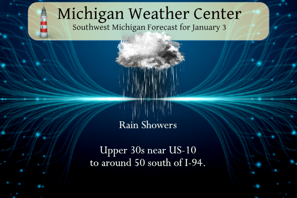
Rain showers will continue to move across southwest Lower Michigan today. Temperatures will range from the upper 30s near US-10 to around 50 south of I-94. Rain will persist into Wednesday, then by late Wednesday into Thursday temperatures will drop back below freezing and precipitation will transition back towards snow to end the week. The CPC outlook is now calling for a continuation of above-normal temperatures and drier-than-normal precipitation in the 6 to 10 day.
Grand Rapids Forecast
7-Day Forecast 42.96°N 85.67°W 1 3 grrLansing Forecast
7-Day Forecast 42.73°N 84.51°W 1 3 lanKalamazoo Forecast
7-Day Forecast 42.31°N 85.67°W 1 3 kzoForecast Discussion
- Rain showers and patchy fog through tonight -

Low pressure over northern Missouri with a warm front extending
east across northern IL/IN/OH will bring rain showers and patchy
fog today. With the front now expected to stay south of our area
we expect high temps to only reach the 40s due to extensive low
cloud cover and ene winds. High temps across our far northern fcst
area will only reach the upper 30s.

This system will weaken with time and 1000-850 mb moisture
transport vectors favor IN/OH for heavier rainfall today. We
now only expect a quarter to half an inch of rainfall through
tonight across most of our area and perhaps isolated higher
amounts along the I-94 corridor in closer proximity to the front.

There is just the slightest chance of an isolated storm over our
extreme southern fcst area from early to mid morning as a result
of weak elevated instability north of the warm front. However the
00Z HREF and HREF trends the past 24-36 hrs suggest that most and
probably all convection will stay south of our area in closer
proximity to the boundary.

There are signals in some of our latest higher res short term
guidance including latest runs of the HRRR that fog could become
fairly widespread and dense tonight. This notion seems reasonable
given abundant lingering low level moisture and weak boundary
layer mixing. Will need to monitor this as it could potentially
end up being a dense fog adv event for at least a portion of our
area tonight into Wednesday morning.

- Still some lingering light precipitation midweek -

The weakening low pressure system will still bring a few light
rain showers and sprinkles Wednesday. Then as thermal profiles
gradually cool a bit Wednesday night we expect light rain showers
to become mixed with/change over to light snow showers. Light snow
showers and flurries will linger Thursday. Any snow accumulations
Wednesday night through Thursday would be very light at less than
an inch.

- Chance of light snow south Saturday -

Tranquil wx with seasonably cool temps is forecast Friday. A weak
low pressure system moving ene across the Ohio Valley region will
bring a chance of light snow to our southern fcst area Saturday.
I just woke up to a clash of thunder on January 3rd. And we literally had 24 inches of snow last weekend… (wow to the wow, as Rocky would say 😂)
It’s January, right?? Special Weather Statement National Weather Service Grand Rapids MI 813 PM EST Tue Jan 3 2023 MIZ046-040200- Isabella MI- 813 PM EST Tue Jan 3 2023 …A strong thunderstorm will impact portions of eastern Isabella County through 900 PM EST… At 813 PM EST, Doppler radar was tracking a strong thunderstorm near Mount Pleasant, moving northeast at 35 mph. HAZARD…Winds in excess of 40 mph and penny size hail. SOURCE…Radar indicated. IMPACT…Gusty winds could knock down tree limbs and blow around unsecured objects. Minor damage to outdoor objects is possible. Locations impacted include… Mount Pleasant… Shepherd… Rosebush…… Read more »
Thank God, there is not an ounce of snow on the ground right now and no change in sight!! Keep it ROCKIN!
Thank God, GR has seen record breaking snowfall so far and still 3 more months of snow coming! Wow, just wow!
Tornado warning extended again in Illinois for Ford and Iroquois County. All just south of Kankakee. I’ve storm chased more than once down in that area and seen some incredible stuff. I was actually in Pontiac, Illinois for the tornado in 2016. My photo actually ended up on the weather channel the next morning which was really cool.
Winter is just flying by and with all the outlooks and teleconnectors, it’s looking warm and dry for the rest of January. Then we get the short month of February and BOOM spring in March! Heck ground hasn’t even frozen and we’re around halfway through winter!
Thank God we at the beginning of winter and plenty of cold and snow will be forthcoming! I love it!
Thank GOD, this is rain and not snow!!
WHAT A STORM!!! Getting pounded with rain and lightning right now!!
Forget the snowblower, might have to get the Lawnmower back out by the end of the week! Wow to the WOW, Just WOW!!!
Wow this is some really odd weather for early January. Currently getting some heavy rain… tornado warnings over in Illinois.
Yes there is a tornado warning and strong rotation only 100 miles south of Chicago.
Looks like a trained spotter reported 40mph winds with the storm in Kent. Also up to .75 inch hail. It’s been a pretty eventful winter so far!
Thunderstorms rolling through in the middle of winter!!! Love it!!!
Days are getting longer and we’re only around 2 months away from Spring!!
Awesome when temps are well above normal during what’s supposed to the coldest time of the year! WHO KNEW AND BRING IT!!!! Winter thunderstorms ROCK!!
Not sure if that’s rain or Kirkwood’s tears falling on my roof right now??
Some interesting lightning stats from Storm Team 8 tonight
Michigan saw more lightning than average in 2022. (Average from 2016-2021)
Michigan ranked 29th in total lightning count in 2022
Michigan ranked 34th by total lightning density in 2022
I may be the only one, but I kinda like days when it’s low clouds, drizzly and foggy. Not all the time of course.
Pretty sure I saw Kirkwood cry at lunch today when discussing the nonexistent snowpack and the lack of any upcoming snow and cold for weeks.
What would be wrong with Kirkwood being a little bummed and liking cold and snow so he any many other Michiganders can enjoy the winter sports they love?
You know it Kyle! Keep up the good work!
Thunderstorms with lightning heading this way out of Chicago. In January. Wow!
I have gotten a response as to the mid 60’s that were reported at Holland on December 29th and 30th I will post this today and tomorrow. I am still waiting to see if I get a response on the departures for Grand Rapids and Lansing. I have done some research on the departures for Grand Rapids, Lansing and Muskegon and will report on that on Saturday. So here is the response for the reading at Holland. Hi James. There was an error with Holland’s temperature sensor which was rectified by one of our technicians via corrective maintenance on December… Read more »
Faulty equipment makes more sense than almost 70 degrees. Maybe GR needs “corrective maintenance” as well? Thanks Slim!
A dreary, damp day. Fog has began to emerge in the past 45 or so minutes.
Well we’re not the only ones looking at green grass this Winter. Even the Alps are devoid of snow!
https://www.usnews.com/news/world/articles/2023-01-02/alpine-slopes-face-snow-shortage-in-unseasonably-warm-winter
Big time warmth across the pond.
https://www.cnn.com/2023/01/03/europe/europe-heat-records-climate-intl/index.html
Wow, that’s incredible. Couldn’t have happened at a better time though with what’s going on over there with Russia.
January is a big month for cold and snow, so when the pattern changes get ready for a wild ride! Winter rocks!
Has there been any hint of a pattern change? Every long range forecast I have seen keeps suggesting above normal temps. In fact, the last one I have seen for my area suggests we won’t see highs below freezing for at least 2 weeks. Very disappointing, I hate muddy, sloppy winters.
The pattern should to switch back on or around 1/18/23! Mark it down and get ready to rock!
At least 15 more days of mild weather? I love it!
NWS has downgraded the 1-3″ snow for Thursday and upped their temps the rest of the week. I love it! Yet another quiet and mild week.
The sunset is 5:20 today. I can finally go for a walk/run at 5 and make it home before dark
I love how we are gaining sunlight into summer now. January is a big month of daylight gains.
Rain in January = horrendous!
What a horrible winter so far for winter activities! We’ve really only had three windy and bitterly cold days to enjoy big snow.
Good Morning. We continue to see mild start to January. The official H/L at Grand Rapids yesterday was 38/35. There was a trace of rain yesterday. No snow, and no sunshine. And there is no official snow on the ground. (there are still snow piles) The overnight temperature has held steady at 37 and at the current time there is light rain falling and it is now 38 here at my house. For today the average H/L is 32/21 the record high of 59 was reported in 2004 and the record low of -9 was in 2014. Todays record snow… Read more »